സാൻ ഫ്രാൻസിസ്കോ ബേ ഏരിയ
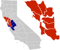
അമേരിക്കൻ ഐക്യനാടുകളിലെ കാലിഫോർണിയ സംസ്ഥാനത്തിന്റെ വടക്കൻ ദിശയിൽ സാൻ ഫ്രാൻസിസ്കോ, സാൻ പബ്ലോ, സൂയിസൺ ഉൾക്കടലിലെ അഴിമുഖങ്ങൾ എന്നിവയെ ചുറ്റി സ്ഥിതിചെയ്യുന്ന ഒരു ജനസാന്ദ്രതയുള്ള പ്രദേശമാണ് സാൻ ഫ്രാൻസിസ്കോ ബേ ഏരിയ (ബേ ഏരിയ എന്നു പൊതുവായി അറിയപ്പെടുന്നു). ഈ പ്രദേശത്തിന്റെ കൃത്യമായ അതിർത്തികൾ സ്രോതസനുസരിച്ച് വ്യത്യാസപ്പെട്ടിരിക്കാമെങ്കിലും മേല്പറഞ്ഞ അഴിമുഖങ്ങളുമായി അതിരുകളുള്ള അലമേഡ, കോൺട്രാ കോസ്റ്റ, മരിൻ, നാപ്പ, സാൻ ഫ്രാൻസിസ്കോ, സാൻ മറ്റേയോ, സാന്താ ക്ലാര, സൊലാനോ, സൊനോമ എന്നിങ്ങനെ ഒൻപത് കൌണ്ടികൾ ഉൾക്കൊള്ളുന്ന മേഖലയെ ഉൾക്കടൽ പ്രദേശമായി പൊതുവേ അംഗീകരിക്കപ്പെട്ടിരിക്കുന്നു. മറ്റ് സ്രോതസ്സുകൾ കൌണ്ടികളുടെ ഭാഗങ്ങൾ അല്ലെങ്കിൽ കൌണ്ടികൾ പൂർണ്ണമായിത്തന്നെ ഒഴിവാക്കുകയോ അതുമല്ലെങ്കിൽ ഉൾക്കടലുമായി അതിർത്തികളില്ലാത്ത സാൻ ബെനിറ്റോ, സാൻ ജൊവാക്വിൻ, സാന്താ ക്രൂസ് പോലെയുള്ള അയൽ കൌണ്ടികളേയും കൂട്ടിച്ചേർത്ത് ഈ വ്യാഖ്യാനത്തെ വിപുലീകരിക്കുകയോ ചെയ്യുന്നു.
San Francisco Bay Area | |
|---|---|
 Clockwise from top: The Stanford University Oval, San Francisco Chinatown with the Bay Bridge in the background, Napa Valley vineyards, the Circle of Palms Plaza in San Jose, the Golden Gate Bridge, the Palo Alto Baylands Nature Preserve, Oakland's downtown skyline, and redwood trees in Muir Woods | |
 Location of the Bay Area within California. The nine-county Bay Area. Additional counties in the larger twelve-county CSA. | |
| Country | |
| State | |
| Subregions | |
| Principal cities | |
| • Nine-county | 6,966 ച മൈ (18,040 ച.കി.മീ.) |
| • CSA | 10,191 ച മൈ (26,390 ച.കി.മീ.) |
| ഉയരത്തിലുള്ള സ്ഥലം | 4,360 അടി (1,330 മീ) |
| താഴ്ന്ന സ്ഥലം | −13 അടി (−4 മീ) |
(2017) | |
| • Nine-county | 7.76 million[4] |
| • Nine-county density | 1,102.5/ച മൈ (425.7/ച.കി.മീ.) |
| • CSA | 8.84 million[5] |
| • CSA density | 859/ച മൈ (332/ച.കി.മീ.) |
| സമയമേഖല | UTC−08:00 (Pacific) |
| • Summer (DST) | UTC−07:00 (PDT) |
| Area codes | 408/669, 415/628, 510/341, 650, 707, 925[6] |
ഏകദേശം 7.68 ദശലക്ഷം ജനങ്ങൾക്ക് സ്വദേശമായ മേൽപ്പറഞ്ഞ ഒമ്പത് കൗണ്ടികൾ ഉൾപ്പെട്ട ഉൾക്കടൽ പ്രദേശം നിരവധി വൻ നഗരങ്ങൾ, പട്ടണങ്ങൾ, വിമാനത്താവളങ്ങൾ കൂടാതെ ബന്ധപ്പെട്ട പ്രാദേശിക, സംസ്ഥാന, ദേശീയോദ്യാനങ്ങൾ എന്നിവയും ഉൾപ്പെടുന്നു. ഈ പ്രദേശം അതിസങ്കീർണമായ മൾട്ടിമോഡൽ ഗതാഗത ശൃംഖലകളുമായി ബന്ധിക്കപ്പെട്ടിരിക്കുന്നു.
ഇതും കാണുക
തിരുത്തുകഅവലംബം
തിരുത്തുക- ↑ "Square Mileage by County". California States Association of Counties. Archived from the original on 2019-02-27. Retrieved September 21, 2017.
- ↑ Hinrichs, Scott (September 28, 2006). "Mt. Hamilton Lick Observatory". Retrieved September 21, 2017.
- ↑ Kurhi, Eric (December 11, 2014). "San Jose: Overwhelmed pumps led to Alviso flooding; residents say it's a 'wake-up call'". San Jose Mercury News. Retrieved September 21, 2017.
- ↑ "Counties Population Totals Tables: 2010–2017". United States Census Bureau, Population Division. March 2018. Archived from the original on 2018-07-14. Retrieved March 22, 2017.
- ↑ "Metropolitan and Micropolitan Statistical Area Population Totals Tables: 2010–2017". United States Census Bureau, Population Division. March 2018. Archived from the original on 2018-07-14. Retrieved March 22, 2018.
- ↑ "Area Code Map for Northern California/Bay Area". White Pages. Retrieved September 21, 2017.
ബാഹ്യ ലിങ്കുകൾ
തിരുത്തുക- Discover the Bay Area website Archived 2018-12-22 at the Wayback Machine. run by Discover California
- Bay Area Tourism Guide[പ്രവർത്തിക്കാത്ത കണ്ണി] by the San Francisco Chamber of Commerce