സാൻ റഫായെൽ
സാൻ റഫായെൽ അമേരിക്കൻ ഐക്യനാടുകളിൽ കാലിഫോർണിയ സംസ്ഥാനത്ത് മാരിൻ കൌണ്ടിയിൽ സ്ഥിതിചെയ്യുന്ന ഒരു നഗരവും കൌണ്ടി ആസ്ഥാനവുമാണ്. ഈ സമ്പന്ന നഗരം സാൻ ഫ്രാൻസിസ്കോ ബേ മേഖലയിലെ വടക്കൻ ഉൾക്കടൽ പ്രദേശത്താണു സ്ഥിതിചെയ്യുന്നത്. 2010 ലെ അമേരിക്കൻ സെൻസസ് രേഖകൾ പ്രകാരം ഈ നഗരത്തിലെ ആകെ ജനസംഖ്യ 57,713 ആയിരുന്നു.
San Rafael | |
|---|---|
| City of San Rafael | |
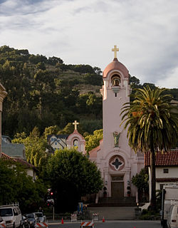
 St. Raphael Church, one of the city's most recognizable landmarks | |
 Location of San Rafael, California | |
| Coordinates: 37°58′25″N 122°31′52″W / 37.97361°N 122.53111°W | |
| Country | |
| State | |
| County | Marin |
| Incorporated | February 18, 1874[1] |
| നാമഹേതു | Archangel Raphael |
| • Mayor | Gary O. Phillips[2] |
| • City Manager | Jim Schutz[3] |
| • Supervisor | District 1: Damon Connolly |
| • State Legislators[5] | Sen. Mike McGuire (D) Asm. Marc Levine (D) |
| • U. S. Rep. | Jared Huffman (D)[4] |
| • ആകെ | 22.52 ച മൈ (58.32 ച.കി.മീ.) |
| • ഭൂമി | 16.57 ച മൈ (42.91 ച.കി.മീ.) |
| • ജലം | 5.95 ച മൈ (15.41 ച.കി.മീ.) 26.55% |
| ഉയരം | 43 അടി (13 മീ) |
| • ആകെ | 57,713 |
| • കണക്ക് (2016)[9] | 58,954 |
| • ജനസാന്ദ്രത | 3,558.52/ച മൈ (1,373.95/ച.കി.മീ.) |
| സമയമേഖല | UTC-8 (PST) |
| • Summer (DST) | UTC-7 (PDT) |
| ZIP code | 94901 |
| Area codes | 415/628 |
| FIPS code | 06-68364 |
| GNIS feature IDs | 1659589, 2411804 |
| വെബ്സൈറ്റ് | www |
ചരിത്രം
തിരുത്തുകഇന്നത്തെ സാൻ റഫായേല് എന്നറിയപ്പെടുന്ന നഗരം ഒരിക്കൽ സാൻ റഫായേൽ നഗരകേന്ദ്രത്തിനു സമീപത്തുണ്ടായിരുന്ന അവാനി-വി, ടെറ ലിണ്ടയ്ക്കു സമീപത്തെ എവു, മാരിൻവുഡിലെ ഷോട്ടോംകോ-ച എന്നിങ്ങനെയുള്ള നിരവധി കോസ്റ്റ് മിവോക്ക് വില്ലേജുകൾ നിലനിന്നിരുന്ന പ്രദേശമായിരുന്നു.
1817 ഡിസംബർ 14 ന് മെക്സിക്കോ സ്പെയിനിൽനിന്നു സ്വാതന്ത്ര്യം നേടുന്നതിന് 4 വർഷങ്ങൾക്കു മുമ്പായി മിഷൻ സാൻ ജോസിലെ ഫാദർ നർസിസോ ഡുറാൻ, മിഷൻ സാൻ ഫ്രാൻസിസ്കോ ഡി അസിസിലെ ഫാദർ ആബെല്ലാ, ലാ ഇഗ്ലേഷ്യ ഡി ന്യൂയെസ്ട്രാ സെനോറ റെയ്ന ഡി ലോസ് ഏഞ്ചലസിലെ ഫാദർ ലൂയിസ് ജിൽ വൈ ടബോഡ തുടങ്ങിയ 3 പാതിരിമാർ ചേർന്ന് 20 ആം സ്പാനിഷ് മിഷന്റെ ഭാഗമായി കൊളോണിയൽ മെക്സിക്കൻ പ്രവിശ്യയായിരുന്ന അൾട്ടാ കാലിഫോർണിയയിൽ ഇന്നത്തെ സാൻ റഫായേൽ നഗരകേന്ദ്രം നിലനിൽക്കുന്നടത്ത് ‘മിഷൻ സാൻ റഫായേല് ആർക്കാഞ്ചൽ’ സ്ഥാപിച്ചിരുന്നു. രോഗശാന്തിയുടെ പ്രധാന ദൈവദൂതനായ റഫായേലിന്റെ നാമമാണ് നഗരത്തിനും മിഷനും നൽകിയിരിക്കുന്നത്.
അവലംബം
തിരുത്തുക- ↑ "California Cities by Incorporation Date". California Association of Local Agency Formation Commissions. Archived from the original (Word) on November 3, 2014. Retrieved August 25, 2014.
- ↑ "Mayor & City Council". City of San Rafael. Retrieved January 18, 2015.
- ↑ "City Manager's Office". City of San Rafael. Archived from the original on 2018-12-25. Retrieved October 22, 2014.
- ↑ "California's 2-ആം Congressional District - Representatives & District Map". Civic Impulse, LLC.
- ↑ "Statewide Database". UC Regents. Retrieved January 18, 2015.
- ↑ "2016 U.S. Gazetteer Files". United States Census Bureau. Retrieved Jun 28, 2017.
- ↑ "San Rafael". Geographic Names Information System. United States Geological Survey.
- ↑ "San Rafael (city) QuickFacts". United States Census Bureau. Archived from the original on 2016-02-22. Retrieved January 28, 2015.
- ↑ ഉദ്ധരിച്ചതിൽ പിഴവ്: അസാധുവായ
<ref>ടാഗ്;USCensusEst2016എന്ന പേരിലെ അവലംബങ്ങൾക്ക് എഴുത്തൊന്നും നൽകിയിട്ടില്ല.


