ലിവർമോർ
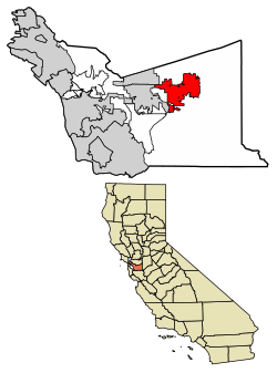
അമേരിക്കൻ ഐക്യനാടുകളിലെ കാലിഫോർണിയ സംസ്ഥാനത്ത് അലമേഡ കൌണ്ടിയിലുൾപ്പെടുന്ന ഒരു നഗരമാണ് ലിവർമോർ (മുൻകാലത്ത്, ലിവർമോർസ്, ലിവർമോർ റാഞ്ച്, നോട്ടിംഗ്ഹാം)[10]. 2017 ലെ ഒരു കണക്കുകൂട്ടൽ പ്രകാരം 89,648, ജനസംഖ്യയുള്ള ഈ നഗരം ട്രൈ-വാലിയിലെ ഏറ്റവും ജനസാന്ദ്രതയുള്ള നഗരമാണ്. കാലിഫോർണിയയുടെ സാൻ ഫ്രാൻസിസ്കോ ബേ മേഖലയുടെ കിഴക്കേ അറ്റത്താണ് ലിവർമോർ സ്ഥിതിചെയ്യുന്നത്. ഭരണത്തിലുള്ള മേയർ ജോൺ മാർച്ചൻറ് ആണ്.
ലിവർമോർ നഗരം | ||
|---|---|---|
 Downtown Livermore | ||
 Location of Livermore in Alameda County, California | ||
| Coordinates: 37°40′55″N 121°46′05″W / 37.68194°N 121.76806°W | ||
| Country | United States | |
| State | California | |
| County | Alameda | |
| Established | 1869 | |
| Incorporated | April 1, 1876[1] | |
| • Mayor | John Marchand [2] | |
| • Vice mayor | Bob Woerner[2] | |
| • City manager | Marc Roberts[3] | |
| • U. S. rep. | Eric Swalwell (D)[4] | |
| • State senator | Steve Glazer (D)[5] | |
| • നഗരം | 26.93 ച മൈ (69.74 ച.കി.മീ.) | |
| • ഭൂമി | 26.92 ച മൈ (69.73 ച.കി.മീ.) | |
| • ജലം | 0.00 ച മൈ (0.01 ച.കി.മീ.) 0.010% | |
| • മെട്രോ | 2,474 ച മൈ (6,410 ച.കി.മീ.) | |
| ഉയരം | 495 അടി (151 മീ) | |
| • നഗരം | 80,968 | |
| • കണക്ക് (2016)[9] | 89,115 | |
| • ജനസാന്ദ്രത | 3,310.24/ച മൈ (1,278.09/ച.കി.മീ.) | |
| • മെട്രോപ്രദേശം | 45,16,276 | |
| • മെട്രോ സാന്ദ്രത | 1,800/ച മൈ (700/ച.കി.മീ.) | |
| സമയമേഖല | UTC−8 (Pacific) | |
| • Summer (DST) | UTC−7 (PDT) | |
| ZIP codes | 94550, 94551 | |
| Area code | 925 | |
| FIPS code | 06-41992 | |
| GNIS feature IDs | 277542, 2410848 | |
| വെബ്സൈറ്റ് | www | |
വില്യം മെൻഡൻഹാൾ സ്ഥാപിച്ച ലിവർമോർ നഗരം, 1840 കളിൽ ഇവിടെ വാസമുറപ്പിച്ച അദ്ദേഹത്തിൻറെ സുഹൃത്തും തദ്ദേശ മേച്ചിൽപ്പുറ ഉടമയുമായിരുന്ന റോബർട്ട് ലിവർമോറിന്റെ പേരിലാണ് അറിയപ്പെടുന്നത്. ലിവർമോറിയം എന്ന രാസ മൂലകത്തിൻറെ നാമകരണത്തിനു നിദാനമായത് ഈ നഗരമാണ്.[11]
ന്യൂ മെക്സിക്കോയിലെ ആൽബുക്കർക്ക് മുഖ്യആസ്ഥാനമായ സാൻഡിയ നാഷണൽ ലബോറട്ടറീസിൻറെ കാലിഫോർണിയ ആസ്ഥാനം ലിവർമോറാണ്. നഗരത്തിൻറെ തെക്ക് ഭാഗത്ത് പ്രാദേശിക മുന്തിരിത്തോട്ടങ്ങൾ സ്ഥിതി ചെയ്യുന്നു. നഗരം അതിന്റെ കേന്ദ്രജില്ല പുനർനിർമ്മിക്കുകയും അമോഡോർ, ലിവർമോർ, സാൻ റമോൺ താഴ്വരകൾ ഉൾപ്പെടുന്ന ട്രൈ-വാലി പ്രദേശത്തിന്റെ ഭാഗമായി കണക്കാക്കുകയും ചെയ്യുന്നു.
അവലംബം
തിരുത്തുക- ↑ "California Cities by Incorporation Date". California Association of Local Agency Formation Commissions. Archived from the original (Word) on November 3, 2014. Retrieved March 27, 2013.
- ↑ 2.0 2.1 "City Council". City of Livermore. Archived from the original on 2018-01-22. Retrieved 2018-01-22.
- ↑ 3.0 3.1 "City Manager's Office". City of Livermore. Archived from the original on 2021-05-11. Retrieved 2018-01-22.
- ↑ "California's 15-ആം Congressional District - Representatives & District Map". Civic Impulse, LLC. Retrieved March 14, 2013.
- ↑ "Senators". State of California. Retrieved March 18, 2013.
- ↑ "2016 U.S. Gazetteer Files". United States Census Bureau. Retrieved Jul 19, 2017.
- ↑ "City of Livermore". Geographic Names Information System. United States Geological Survey.
- ↑ "E-1 Population Estimates". California Department of Finance. Archived from the original on 2020-06-10. Retrieved December 22, 2017.
- ↑ ഉദ്ധരിച്ചതിൽ പിഴവ്: അസാധുവായ
<ref>ടാഗ്;USCensusEst2016എന്ന പേരിലെ അവലംബങ്ങൾക്ക് എഴുത്തൊന്നും നൽകിയിട്ടില്ല. - ↑ Durham, David L. (1998). California's Geographic Names: A Gazetteer of Historic and Modern Names of the State. Clovis, Calif.: Word Dancer Press. p. 655. ISBN 1-884995-14-4.
- ↑ [1]
പുറം കണ്ണികൾ
തിരുത്തുകവിക്കിവൊയേജിൽ നിന്നുള്ള ലിവർമോർ യാത്രാ സഹായി
- ഔദ്യോഗിക വെബ്സൈറ്റ്
- Livermore Community Guide
- Livermore Area Recreation and Park District Archived 2018-08-23 at the Wayback Machine.
- Livermore Shakespeare Festival
- Livermore Valley Performing Arts Center
- Livermore Independent, Weekly Newspaper
- Livermore Links Archived 2018-08-19 at the Wayback Machine.
- Livermore Police Department Archived 2018-01-18 at the Wayback Machine.
- i-GATE business hub website
