ദക്ഷിണാഫ്രിക്കയിലെ പ്രവിശ്യകൾ
ഭരണസൗകര്യാർത്ഥം ദക്ഷിണാഫ്രിക്കയെ 9 പ്രവിശ്യകളായി വിഭജിച്ചിരിക്കുന്നു. (diporofense; diprovense; diprofense; provinsies; izifundazwe; iimfunda; amaphondo; tifundza; mavunḓu; swifundzankulu). 1994ലെ പൊതു തിരഞ്ഞെടുപ്പ് ദിനത്തിലെ സായാഹ്നത്തിൽ, ബന്ദുസ്റ്റാൻ എന്നറിയപ്പെട്ടിരുന്ന ഭരണപ്രദേശങ്ങൾ, പുനഃക്രമീകരിക്കുകയും, നിലവിലുള്ള നാല് പ്രവിശ്യകൾ വിഭജിച്ച് 9 പ്രവിശ്യകളായി പുനഃസംഘടിപ്പിക്കുകയും ചെയ്തു. പിന്നീടുവന്ന ഭരണഘടനാ ഭേദഗതികൾ പ്രകാരം ഈ പ്രവിശ്യകളുടെ അതിർത്തികളിൽ ചില പുനഃക്രമീകരണങ്ങൾ വന്നിട്ടുണ്ട്.
-
1910-ൽ യൂണിയൻ രൂപികരണസമയത്ത് ദക്ഷിണാഫ്രിക്കയിൽ നിലനിന്നിരുന്ന പ്രവിശ്യകൾ
-
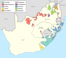
വർണവിവേചനത്തിന്റെ അവസാനത്തോടടുത്തപ്പോൾ ആഫ്രിക്കയിൽ നിലവിലുണ്ടായിരുന്ന പ്രവിശ്യകളും, ബന്ദുസ്റ്റാനുകളും
-
ഇന്ന് ദക്ഷിണാഫ്രിക്കയിലുള്ള 9 പ്രവിശ്യകൾ
| സൗത്ത് ആഫ്രിക്കയിലെ പ്രവിശ്യകൾ | |
|---|---|
| Category | യൂണിറ്ററി സ്റ്റേറ്റ് |
| Location | ദക്ഷിണാഫ്രിക്ക ഗണരാജ്യം |
| എണ്ണം | 9 പ്രവിശ്യകൾ |
| ജനസംഖ്യ | 1,145,861 (Northern Cape) – 12,272,263 (Gauteng) |
| വിസ്തീർണ്ണം | 47,080 കി.m2 (18,178 ച മൈ) (Gauteng) – 372,890 കി.m2 (143,973 ച മൈ) (Northern Cape) |
| സർക്കാർ | Provincial government, National government |
| സബ്ഡിവിഷനുകൾ | ജില്ലകൾ |
പ്രവിശ്യകൾ
തിരുത്തുക| പ്രവിശ്യ | തലസ്ഥാനം | ഏറ്റവും
വലിയ നഗരം |
വിസ്തീർണം[1] | ജനസംഖ്യ
(2011)[2] |
ജന സാന്ദ്രത (2011) | മാനവ വികസന സൂചിക (2003) [3] |
|---|---|---|---|---|---|---|
| ഈസ്റ്റേൺ കേപ് | ഭിഷൊ (Bisho) | പോർട്ട് എലിസബത്ത് | 168,966 കി.m2 (65,238 ച മൈ) | 6,562,053 | 38.8/കിമീ2 (100/ച മൈ) | 0.62 |
| ഫ്രീ സ്റ്റേറ്റ് | ബ്ലൂംഫൗണ്ടെയിൻ | ബ്ലൂംഫൗണ്ടെയിൻ | 129,825 കി.m2 (50,126 ച മൈ) | 2,745,590 | 21.1/കിമീ2 (55/ച മൈ) | 0.67 |
| ഗൗറ്റെങ് | ജൊഹാനസ്ബർഗ് | ജൊഹാനസ്ബർഗ് | 18,178 കി.m2 (7,019 ച മൈ) | 12,272,263 | 675.1/കിമീ2 (1,749/ച മൈ) | 0.74 |
| ക്വാസുളു-നറ്റാൽ | Pietermaritzburg ‡ | Durban | 94,361 കി.m2 (36,433 ച മൈ) | 10,267,300 | 108.8/കിമീ2 (282/ച മൈ) | 0.63 |
| ലിമ്പോപൊ | Polokwane (Pietersburg) | Polokwane | 125,754 കി.m2 (48,554 ച മൈ) | 5,404,868 | 43.0/കിമീ2 (111/ച മൈ) | 0.59 |
| മ്പുമാലങ | Nelspruit | Nelspruit | 76,495 കി.m2 (29,535 ച മൈ) | 4,039,939 | 52.8/കിമീ2 (137/ച മൈ) | 0.65 |
| നോർത്ത് വെസ്റ്റ് | Mahikeng (Mafikeng) | Rustenburg | 104,882 കി.m2 (40,495 ച മൈ) | 3,509,953 | 33.5/കിമീ2 (87/ച മൈ) | 0.61 |
| നോർത്തേൺ കേപ് | കിംബെർളി | കിംബെർളി | 372,889 കി.m2 (143,973 ച മൈ) | 1,145,861 | 3.1/കിമീ2 (8.0/ച മൈ) | 0.69 |
| വെസ്റ്റേർൺ കേപ് † | കേപ് ടൗൺ | കേപ് ടൗൺ | 129,462 കി.m2 (49,986 ച മൈ) | 5,822,734 | 45.0/കിമീ2 (117/ച മൈ) | 0.77 |
| റിപ്പബ്ലിക് ഓഫ് സൗത്ത് ആഫ്രിക്ക | പ്രിട്ടോറിയ, കേപ് ടൗൺ, ബ്ലൂംഫൗണ്ടെയിൻ | ജൊഹാനസ്ബർഗ് | 1,220,813 കി.m2 (471,359 ച മൈ) | 51,770,560 | 42.4/കിമീ2 (110/ച മൈ) | 0.67 |
Footnotes:
- † These statistics do not include the Prince Edward Islands (335 കി.m2, 129 ച മൈ, with no permanent residents), which are South African territories in the sub-Antarctic Indian Ocean but part of the Western Cape for legal and electoral purposes.
- ‡ Pietermaritzburg and Ulundi were joint capitals of KwaZulu-Natal from 1994 to 2004.
അവലംബം
തിരുത്തുക- ↑ Census 2011: Census in brief. Pretoria: Statistics South Africa. 2012. p. 9. ISBN 9780621413885. Archived from the original (PDF) on 2018-12-25. Retrieved 2017-07-08.
- ↑ Census 2011: Census in brief. Pretoria: Statistics South Africa. 2012. p. 18. ISBN 9780621413885. Archived from the original (PDF) on 2018-12-25. Retrieved 2017-07-08.
- ↑ Adelzadeh, Asghar; et al. South Africa Human Development Report 2003 (PDF). Cape Town: Oxford University Press. p. 282. ISBN 978-0-19-578418-3. Archived from the original (PDF) on 2016-01-19. Retrieved 2017-07-08.


