ഡൈനിപ്പർ
ഡൈനിപ്പർ (/ˈ(d)niːpər/) or Dnipro (/(d)niːˈproʊ/)[a] യൂറോപ്പിലെ പ്രധാന അതിർത്തി കടന്നുള്ള നദികളിലൊന്നാണ്. റഷ്യയിലെ സ്മോലെൻസ്കി നഗരത്തിനുസമീപത്തെ വാൽഡായി കുന്നുകളിൽ നിന്ന് ഉത്ഭവിച്ച് ബെലാറസ്, ഉക്രെയ്ൻ എന്നിവിടങ്ങളിലൂടെ ഒഴുകി ഇത് കരിങ്കടലിലേക്ക് പതിക്കുന്നു. ഉക്രെയ്നിലെയും ബെലാറസിലെയും ഏറ്റവും നീളമേറിയ നദിയും വോൾഗ, ഡാന്യൂബ്, യുറാൽ നദികൾക്ക് ശേഷം യൂറോപ്പിലെ നാലാമത്തെ നീളമേറിയ നദിയുമാണ് ഇത്.[2] ഏകദേശം 2,200 കിലോമീറ്റർ (1,400 മൈൽ) നീളമുള്ള[3] ഇതിന് 504,000 ചതുരശ്ര കിലോമീറ്റർ (195,000 ചതുരശ്ര മൈൽ) വിസ്തൃതിയുള്ള നീർത്തടമുണ്ട്.
| ഡൈനിപ്പർ | |
|---|---|
 Dnieper Reservoir downstream from Dnipro city, Ukraine | |
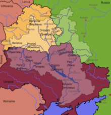
 ഡൈനിപ്പർ നദിയുടെ നീർത്തടം | |
| നദിയുടെ പേര് |
|
| Countries |
|
| Cities | |
| Physical characteristics | |
| പ്രധാന സ്രോതസ്സ് | വാൽദായ് ഹിൽസ്, റഷ്യ 220 മീ (720 അടി) 55°52′18.08″N 33°43′27.08″E / 55.8716889°N 33.7241889°E |
| നദീമുഖം | ഡൈനിപ്പർ ഡെൽറ്റ ഉക്രെയ്ൻ 0 മീ (0 അടി) 46°30′00″N 32°20′00″E / 46.50000°N 32.33333°E |
| നീളം | 2,201 കി.മീ (1,368 മൈ) |
| Discharge |
|
| നദീതട പ്രത്യേകതകൾ | |
| നദീതട വിസ്തൃതി | 504,000 കി.m2 (5.43×10¹² sq ft) |
| പോഷകനദികൾ | |
| Protection status | |
| Official name | Dnieper River Floodplain |
| Designated | 29 May 2014 |
| Reference no. | 2244[1] |
അവലംബം
തിരുത്തുക- ↑ Russian: Днепр, romanized: Dnepr; Ukrainian: Дніпро pronounced [dʲnʲiˈprɔ] ; Belarusian: Дняпро.
- ↑ "Dnieper River Floodplain". Ramsar Sites Information Service. Retrieved 25 April 2018.
- ↑ "Dnieper River". www.britannica.com (in ഇംഗ്ലീഷ്). Retrieved 2022-05-25.
- ↑ "Main Geographic Characteristics of the Republic of Belarus. Main characteristics of the largest rivers of Belarus". Land of Ancestors. Data of the Ministry of Natural Resources and Environmental Protection of the Republic of Belarus. 2011. Retrieved 27 September 2013.