കൂസ നദി
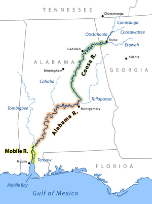
കൂസ നദി, അമേരിക്കൻ ഐക്യനാടുകളിലെ അലബാമ, ജോർജിയ സംസ്ഥാനങ്ങളിലൂടെ ഒഴുകുന്ന അലബാമ നദിയുടെ ഒരു കൈവഴിയാണ്. ഈ നദിക്ക് ഏകദേശം 280 മൈൽ (450 കിലോമീറ്റർ) നീളമുണ്ട്.[1] ജോർജിയയിലെ റോം നഗരത്തിൽ ഊസ്റ്റാനൗല, എറ്റോവ നദികളുടെ സംഗമസ്ഥാനത്തുനിന്ന് ആരംഭിക്കുന്ന കൂസ നദി അലബാമ സംസ്ഥാന തലസ്ഥാനമായ മോണ്ട്ഗോമറിയുടെ വടക്കുകിഴക്കായി തല്ലപൂസ നദിയിൽ ലയിച്ച് വേതുമ്പ്കയ്ക്ക് തൊട്ടു തെക്കായി അലബാമ നദി രൂപം കൊള്ളുന്നു. കൂസ നദിയുടെ 90 ശതമാനം ഭാഗവും അലബാമയിലാണുള്ളത്. അലബാമയിലെ കൂസ കൗണ്ടി സ്ഥിതി ചെയ്യുന്നത് കൂസ നദിയോരത്താണ്.
| കൂസ നദി | |
|---|---|
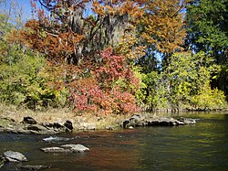
 Fall colors on the Coosa River near Wetumpka, Alabama | |
 The Coosa River is the major tributary when it joins the Tallapoosa River near Wetumpka, Alabama to form the Alabama River. | |
| Country | United States |
| State | Alabama, Georgia |
| Physical characteristics | |
| പ്രധാന സ്രോതസ്സ് | junction of Oostanaula River and Etowah River at Rome, Georgia 575 അടി (175 മീ)[1] 34°15′14″N 85°10′39″W / 34.25389°N 85.17750°W[2] |
| നദീമുഖം | Alabama River near Montgomery, Alabama 121 അടി (37 മീ)[2] 32°29′10″N 86°16′40″W / 32.48611°N 86.27778°W[2] |
| നീളം | 280 മൈ (450 കി.മീ)[1] |
| Discharge | |
| നദീതട പ്രത്യേകതകൾ | |
| നദീതട വിസ്തൃതി | 10,100 ച മൈ ([convert: unknown unit])[4] |
അലബാമയിലെ ഏറ്റവും വികസിതമായ നദികളിലൊന്നാണ് കൂസ. സതേൺ കമ്പനിയുടെ ഒരു യൂണിറ്റായ അലബാമ പവർ, കൂസ നദിയുടെ ഭൂരിഭാഗത്തിലും അണക്കെട്ടുകൾ നിർമ്മിച്ചിരിക്കുന്നു. അവർക്ക് ഇവിടെ ഏഴ് ഡാമുകളും പവർഹൌകളുമുണ്ട്.
അവലംബം
തിരുത്തുക- ↑ 1.0 1.1 1.2 U.S. Geological Survey. National Hydrography Dataset high-resolution flowline data. The National Map Archived 2016-06-30 at the Wayback Machine., accessed April 27, 2011
- ↑ 2.0 2.1 2.2 U.S. Geological Survey Geographic Names Information System: Coosa River
- ↑ 3.0 3.1 "Water resources data for the United States, Water Year 2009; gage 02411000, Coosa River at Jordan Dam near Wetumpka, AL" (PDF). USGS. Retrieved 4 August 2010.
- ↑ "Water resources data for the United States, Water Year 2009; gage 02411600, Coosa River at Wetumpka, AL" (PDF). USGS. Retrieved 4 August 2010.