ഗ്രാൻഡ് പ്രയറി (ടെക്സസ്)
അമേരിക്കൻ ഐക്യനാടുകളിലെ ടെക്സസ് സംസ്ഥാനത്ത് ഡാളസ്, എല്ലിസ്, റ്ററന്റ് കൗണ്ടികളിൽപ്പെട്ട ഒരു നഗരമാണ് ഗ്രാൻഡ് പ്രയറി. ടെക്സസിലെ പതിനഞ്ചാമത്തെ ഏറ്റവും ജനവാസമേറിയ നഗരമായ ഗ്രാൻഡ് പ്രയറിയിൽ 2010ലെ യു.എസ്. സെൻസസ് പ്രകാരം 175,396 പേർ വസിക്കുന്നു[4].
സിറ്റി ഓഫ് ഗ്രാൻഡ് പ്രയറി | |
|---|---|
 Watertower at Market Square | |
| Nickname(s): GP, ഗൺപോയിന്റ് | |
| Motto(s): "Dream Big, Play Hard"[1] | |
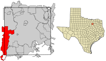
 ടെക്സസിലെ ഡാളസ് കൗണ്ടിയിൽ സ്ഥാനം | |
| രാജ്യം | അമേരിക്കൻ ഐക്യനാടുകൾ |
| സംസ്ഥാനം | ടെക്സസ് |
| കൗണ്ടികൾ | ഡാളസ്, റ്റരന്റ്, എല്ലിസ് |
| • സിറ്റി കൗൺസിൽ | മേയർ ചാൾസ് ഇംഗ്ലണ്ട് റിച്ചാർഡ് ഫ്രെഗോ മാർക്ക് ഹെപ്വർത്ത് റൂത്ത് ജായ്ക്ക്സൺ റോൺ ജെൻസൺ ഗ്രെഗ് ഗെയ്സ്നർ ടോണി ഷോട്ട്വെൽ ജിം സ്വാഫോർഡ് ബിൽ തോൺ |
| • സിറ്റി മാനേജർ | ടോം ഹാർട്ട് |
| • ആകെ | 81.1 ച മൈ (210.0 ച.കി.മീ.) |
| • ഭൂമി | 72.1 ച മൈ (186.8 ച.കി.മീ.) |
| • ജലം | 9.0 ച മൈ (23.3 ച.കി.മീ.) |
| ഉയരം | 515 അടി (157 മീ) |
(2010) | |
| • ആകെ | 1,75,396 |
| • ജനസാന്ദ്രത | 2,200/ച മൈ (840/ച.കി.മീ.) |
| സമയമേഖല | UTC-6 (CST) |
| • Summer (DST) | UTC-5 (CDT) |
| പിൻകോഡുകൾ | 75050-75054 |
| ഏരിയ കോഡ് | 972, 214, 469, 817, 682 |
| FIPS കോഡ് | 48-30464[2] |
| GNIS ഫീച്ചർ ID | 1336802[3] |
| വെബ്സൈറ്റ് | www.gptx.org http://www.gptx.org www.gptx.org |
ഭൂമിശാസ്ത്രം
തിരുത്തുകഗ്രാൻഡ് പ്രയറി നഗരം സ്ഥിതിചെയ്യുന്ന അക്ഷരേഖാംശങ്ങൾ 32°42′55″N 97°1′1″W / 32.71528°N 97.01694°W (32.715266, -97.016864)[5] ആണ്.
യുണൈറ്റഡ് സ്റ്റേറ്റ്സ് സെൻസസ് ബ്യൂറോയുടെ കണക്കുപ്രകാരം, നഗരത്തിന്റെ മൊത്തം വിസ്തീർണ്ണം 2.260×10⁹ square feet (210.0 കി.m2) ആണ്. ഇതിൽ 2.011×10⁹ square feet (186.8 കി.m2) കരപ്രദേശവും 251,000,000 square feet (23.3 കി.m2) (11.08%) ജലവുമാണ്.[6]
കാലാവസ്ഥ
തിരുത്തുക| ഗ്രാൻഡ് പ്രയറി (ടെക്സസ്) പ്രദേശത്തെ കാലാവസ്ഥ | |||||||||||||
|---|---|---|---|---|---|---|---|---|---|---|---|---|---|
| മാസം | ജനു | ഫെബ്രു | മാർ | ഏപ്രി | മേയ് | ജൂൺ | ജൂലൈ | ഓഗ | സെപ് | ഒക് | നവം | ഡിസം | വർഷം |
| ശരാശരി കൂടിയ °F (°C) | 57 (14) |
61 (16) |
68 (20) |
76 (24) |
84 (29) |
91 (33) |
96 (36) |
96 (36) |
88 (31) |
78 (26) |
67 (19) |
57 (14) |
76.6 (24.8) |
| ശരാശരി താഴ്ന്ന °F (°C) | 35 (2) |
40 (4) |
47 (8) |
55 (13) |
64 (18) |
71 (22) |
75 (24) |
75 (24) |
68 (20) |
57 (14) |
46 (8) |
37 (3) |
55.8 (13.3) |
| മഴ/മഞ്ഞ് inches (mm) | 2.13 (54.1) |
2.77 (70.4) |
3.49 (88.6) |
3.07 (78) |
4.90 (124.5) |
3.79 (96.3) |
2.16 (54.9) |
1.91 (48.5) |
2.55 (64.8) |
4.22 (107.2) |
2.71 (68.8) |
2.55 (64.8) |
36.25 (920.9) |
| ഉറവിടം: The Weather Channel (extremes) [7] | |||||||||||||
അവലംബം
തിരുത്തുക- ↑ "City of Grand Prairie Texas". City of Grand Prairie Texas. Retrieved October 19, 2012.
- ↑ "American FactFinder". United States Census Bureau. Retrieved 2008-01-31.
- ↑ "US Board on Geographic Names". United States Geological Survey. 2007-10-25. Retrieved 2008-01-31.
{{cite web}}: Check date values in:|date=(help) - ↑ "Profile of General Population and Housing Characteristics: 2010 Demographic Profile Data (DP-1): Grand Prairie city, Texas". U.S. Census Bureau, American Factfinder. Retrieved November 30, 2011.
- ↑ "US Gazetteer files: 2000 and 1990". United States Census Bureau. 2005-05-03. Retrieved 2008-01-31.
{{cite web}}: Check date values in:|date=(help) - ↑ "Geographic Identifiers: 2010 Demographic Profile Data (G001): Grand Prairie city, Texas". U.S. Census Bureau, American Factfinder. Retrieved November 30, 2011.
- ↑
"Monthly Averages for Grand Prairie, TX". The Weather Channel. Retrieved 2012−03−26.
{{cite web}}: Check date values in:|accessdate=(help)