ഈറി തടാകം
ഈറി തടാകം[5] (/ˈɪəri/; French: Lac Érié) വടക്കേ അമേരിക്കയിലെ പഞ്ച മഹാതടാകങ്ങളിൽ ഉപരിതല വിസ്തീർണ്ണമനുസരിച്ച് നാലാമത്തെ വലിയ തടാകമാണ്. അതുപോലെതന്നെ ഉപരിതലവിസ്തീർണ്ണം കണക്കാക്കിയാൽ ഇത് ലോകത്തെ വലിയ തടാകങ്ങളിൽ പതിനൊന്നാം സ്ഥാനം അലങ്കരിക്കുന്നു.[1][6] മഹാതടാകങ്ങളിൽ[7][8] ഏറ്റവും തെക്കുദിശയിലുള്ളതും ഏറ്റവും ആഴം കുറഞ്ഞതും വിസ്തീർണ്ണത്തിൽ ഏറ്റവും ചെറുതുമാണിത്. തടാകത്തിന്റെ പരമാവധി ആഴം 210 അടിയാണ് (64 മീറ്റർ).
| ഈറി തടാകം | |
|---|---|
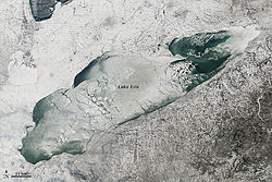
 ഈറി തടാകം ജനുവരി 9, 2014 ന് | |
 The Great Lakes, with Lake Erie highlighted in darker blue | |
| സ്ഥാനം | വടക്കേ അമേരിക്ക |
| ഗ്രൂപ്പ് | Great Lakes |
| നിർദ്ദേശാങ്കങ്ങൾ | 42°12′N 81°12′W / 42.2°N 81.2°W |
| Lake type | Glacial |
| പ്രാഥമിക അന്തർപ്രവാഹം | Detroit River[1] |
| Primary outflows | നയാഗ്ര നദി വെല്ലാൻ്റ് കനാൽ[2] |
| Basin countries | കാനഡ അമേരിക്കൻ ഐക്യനാടുകൾ |
| പരമാവധി നീളം | 241 മൈ (388 കി.മീ) |
| പരമാവധി വീതി | 57 മൈ (92 കി.മീ) |
| Surface area | 9,910 ച മൈ (25,667 കി.m2)[2] |
| ശരാശരി ആഴം | 62 അടി (19 മീ)[2] |
| പരമാവധി ആഴം | 210 അടി (64 മീ)[3] |
| Water volume | 116 cu mi (480 കി.m3)[2] |
| Residence time | 2.6 years |
| തീരത്തിന്റെ നീളം1 | 799 മൈ (1,286 കി.മീ) plus 72 മൈ (116 കി.മീ) for islands[4] |
| ഉപരിതല ഉയരം | 569 അടി (173 മീ)[2] |
| ദ്വീപുകൾ | 24+ (see list) |
| അധിവാസ സ്ഥലങ്ങൾ | Buffalo, New York Erie, Pennsylvania Toledo, Ohio Cleveland, Ohio |
| അവലംബം | [3] |
| 1 Shore length is not a well-defined measure. | |

കാനഡയും അമേരിക്കൻ ഐക്യനാടുകളും തമ്മിലുള്ള അന്തർദേശീയ അതിർത്തിയിൽ സ്ഥിതിചെയ്യുന്ന ഈറി തടാകത്തിന്റെ വടക്കൻ തീരത്ത് കനേഡിയൻ പ്രവിശ്യയായ ഒണ്ടാറിയോ ആണ്, പ്രത്യേകിച്ചും ഒന്റാറിയാ ഉപദ്വീപ്. ഇതിന്റെ പടിഞ്ഞാറ്, തെക്ക്, കിഴക്കൻ തീരങ്ങളിലായി അമേരിക്കൻ ഐക്യനാടുകളിലെ സംസ്ഥാനങ്ങളായ മിഷിഗൺ, ഒഹായോ, പെൻസിൽവാനിയ, ന്യൂയോർക്ക് എന്നിവ സ്ഥിതിചെയ്യുന്നു. ഈ അധികാരപരിധികൾ തടാകത്തിന്റെ ഉപരിതല പ്രദേശങ്ങളെ ജലാതിർത്തികളായി വിഭജിക്കുന്നു.
ഈ തടാകത്തിന്റെ തെക്കൻ തീരങ്ങളിൽ അധിവസിച്ചിരുന്ന അമരേന്ത്യൻ വർഗ്ഗക്കാരായ ഈറി ജനതയാണ് തടാകത്തിന് ഈ പേരുനൽകിയത്. ആദിവാസി നാമമായ "ഈറി" എന്നത് erielhonan "നീണ്ട വാൽ" എന്ന അർഥം വരുന്ന ഇറോക്യൻ പദത്തിന്റെ ചുരുക്കരൂപമാണ്. [9]
ഹ്യൂറോൺ തടാകത്തിന് താഴെയായി സ്ഥിതിചെയ്യുന്ന ഈറിയുടെ പ്രാഥമിക കവാടം ഡെട്രോയിറ്റ് നദിയാണ്. തടാകത്തിൽ നിന്നുള്ള പ്രധാന പ്രകൃതിദത്ത പ്രവാഹം നയാഗ്ര നദി വഴിയാണ്. നയാഗ്ര വെള്ളച്ചാട്ടത്തിന് സമീപം ന്യൂയോർക്കിലെ ലെവിസ്റ്റൺ, ഒന്റാറിയോയിലെ ക്വീൻസ്റ്റൺ എന്നിവിടങ്ങളിൽ വലിയ ടർബൈനുകൾ കറങ്ങുന്നതിന്റെ ഫലമായി ഇത് കാനഡയ്ക്കും യുഎസിനും ജലവൈദ്യുതി നൽകുന്നു.[10] സെന്റ് ലോറൻസ് സീവേയുടെ ഭാഗമായ വെല്ലണ്ട് കനാൽ വഴിയാണ് പ്രവാഹം കാണപ്പെടുന്നത്. ഈറി തടാകത്തിലെ ഒന്റാറിയോയിലെ പോർട്ട് കോൾബോർണിൽ നിന്ന് ഒന്റാറിയോ തടാകത്തിലെ സെന്റ് കാതറൈൻസിലേക്ക് 326 അടി (99 മീറ്റർ) ഉയരത്തിൽ നിന്ന് കപ്പൽ പാതകൾക്കായി ജലം തിരിച്ചുവിടുന്നു. അമിത മത്സ്യബന്ധനം, മലിനീകരണം, ആൽഗകളുടെ പുഷ്പങ്ങൾ, യൂട്രോഫിക്കേഷൻ തുടങ്ങിയ തലക്കെട്ടുകൾ പതിറ്റാണ്ടുകളായി ഈറി തടാകം പാരിസ്ഥിതിക ആരോഗ്യത്തിന് ഭംഗം വരുത്തുന്നു. [11][12][13]
ഭൂമിശാസ്ത്രം
തിരുത്തുകഇതും കാണുക
തിരുത്തുകപൊതുവെ വലിയ തടാകങ്ങൾ
തിരുത്തുക- Great Lakes Areas of Concern
- Great Lakes census statistical areas
- Great Lakes Commission
- Great Lakes Waterway
- Great Recycling and Northern Development Canal
- Great Storm of 1913
- International Boundary Waters Treaty
- List of cities along the Great Lakes
- Sixty Years' War for control of the Great Lakes
- Snowbelt
- Third Coast
View
തിരുത്തുകഅവലംബം
തിരുത്തുക- ↑ 1.0 1.1 State of Ohio, Division of Geological Survey, Lake Erie Facts Archived 2013-03-25 at the Wayback Machine., Accessed May 4, 2013
- ↑ 2.0 2.1 2.2 2.3 2.4 US Environmental Protection Agency, Great Lakes Factsheet No. 1, Accessed May 4, 2013
- ↑ 3.0 3.1 Wright, John W., ed. (2006). The New York Times Almanac (2007 ed.). New York, New York: Penguin Books. p. 64. ISBN 0-14-303820-6.
- ↑ Shorelines of the Great Lakes Archived April 5, 2015, at the Wayback Machine.
- ↑ United States Geological Survey Hydrological Unit Code: 04-12-02-00[അവലംബം ആവശ്യമാണ്]
- ↑ 10 Largest Lakes in the World. worldatlas.com.
- ↑ "Lake Erie – Facts and Figures". Great Lakes Information Network. Archived from the original on ജനുവരി 4, 2013. Retrieved ഡിസംബർ 10, 2012.
- ↑ "Erie, Lake - FactMonster". www.factmonster.com.
- ↑ Room, A. (2006). Placenames of the World: Origins And Meanings of the Names for 6,600 Countries, Cities, Territories, Natural Features And Historic Sites. McFarland. p. 150. ISBN 978-0-7864-2248-7.
- ↑ "From Honeymoon City to Hydro City". CBC Digital Archives. August 25, 1957. Retrieved January 26, 2011.
{{cite news}}: Italic or bold markup not allowed in:|publisher=(help) - ↑ Nancy Macdonald (August 20, 2009). "Canada's sickest lake". Macleans.CA. Archived from the original on August 24, 2009. Retrieved January 26, 2011.
- ↑ Michael Wines (March 14, 2013). "Spring Rain, Then Foul Algae in Ailing Lake Erie". The New York Times. Retrieved March 15, 2013.
- ↑ "Researchers track Lake Erie algae blooms". USA Today. September 13, 2007. Retrieved January 24, 2011.
<ref> റ്റാഗ് "twsX213" എന്ന പേരോടെ <references> എന്നതിൽ നിർവചിച്ചിട്ടുണ്ടെങ്കിലും ആദ്യ എഴുത്തിൽ ഉപയോഗിക്കുന്നില്ല.കൂടുതൽ വായനയ്ക്ക്
തിരുത്തുക- Assel, R.A. (1983). Lake Erie regional ice cover analysis: preliminary results [NOAA Technical Memorandum ERL GLERL 48]. Ann Arbor, MI: U.S. Department of Commerce, National Oceanic and Atmospheric Administration, Environmental Research Laboratories, Great Lakes Environmental Research Laboratory.
- Saylor, J.H. and G.S. Miller. (1983). Investigation of the currents and density structure of Lake Erie [NOAA Technical Memorandum ERL GLERL 49]. Ann Arbor, MI: U.S. Department of Commerce, National Oceanic and Atmospheric Administration, Environmental Research Laboratories, Great Lakes Environmental Research Laboratory.
പുറം കണ്ണികൾ
തിരുത്തുക- Geographic data related to ഈറി തടാകം at OpenStreetMap
- Lake Erie Islands Directory[പ്രവർത്തിക്കാത്ത കണ്ണി]
- How many Islands are there in Lake Erie?
- EPA's Great Lakes Atlas
- Great Lakes Coast Watch Archived 2008-05-11 at the Wayback Machine.
- Lake Erie Bathymetry – National Geophysical Data Center
- Frozen lighthouse video via Slate Magazine Archived 2011-01-19 at the Wayback Machine.
- Explore the Lake Erie Islands Archived 2012-02-22 at the Wayback Machine.