അഗൌറാ ഹിൽസ്
(Agoura Hills, California എന്ന താളിൽ നിന്നും തിരിച്ചുവിട്ടതു പ്രകാരം)
അഗൌറാ ഹിൽസ് കാലിഫോർണിയയിലെ ലോസ് എഞ്ചലസ് കൌണ്ടിയിൽ സ്ഥിതി ചെയ്യുന്ന ഒരു പട്ടണമാണ്. ഈ പട്ടണത്തിലെ ആകെ ജനസംഖ്യ 2014 ൽ 20,843 ആയി കണക്കു കൂട്ടിയിരിക്കുന്നു.[9] സിമി ഹിൽസിനും സാന്താ മോണിക്ക മലനിരകൾക്കുമിടയിൽ കിഴക്കൻ കൊനെജൊ താഴ്വരയിലാണ് ഈ പട്ടണത്തിൻറെ സ്ഥാനം. പട്ടണത്തിൻറെ കിഴക്ക്, പടിഞ്ഞാറ്, തെക്ക് അതിരുകളായി ലോസ് ആഞ്ജലസ് കൌണ്ടിയും വടക്കു വശത്തായി വെഞ്ചുറ കൌണ്ടിയുമാണ്. ലോസ് ആഞ്ചലസ് നഗരമദ്ധ്യത്തിന് 30 മൈൽ (48 കി.മീ.) വടക്കു പടിഞ്ഞാറായും ലോസ് ആഞ്ജലസ് നഗരപരിധിയുടെ (വുഡ്ലാൻറ് ഹില്ലിനു സമീപം) ഏകദേശം 10 മൈൽ (16 കി.മീ.) പടിഞ്ഞാറും ആയിട്ടാണ് ഈ പട്ടണത്തിൻറ സ്ഥാനം.
അഗൌറാ ഹിൽസ്, കാലിഫോർണിയ | |
|---|---|
| City of Agoura Hills | |
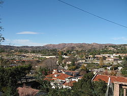
 View of Agoura Hills looking from southern edge of the Historic Quarter in December 2006. | |
| Motto(s): "The Gateway to the Santa Monica Mountains"[2] | |
 Location of Agoura Hills in California | |
| Coordinates: 34°9′12″N 118°45′42″W / 34.15333°N 118.76167°W | |
| Country | |
| State | |
| County | |
| Settled (by the Spanish) | 1700s |
| Incorporated | December 8, 1982[3] |
| • Mayor | Harry Schwartz[1] |
| • Mayor pro tem | Denis Weber |
| • ആകെ | 7.822 ച മൈ (20.260 ച.കി.മീ.) |
| • ഭൂമി | 7.793 ച മൈ (20.184 ച.കി.മീ.) |
| • ജലം | 0.029 ച മൈ (0.076 ച.കി.മീ.) 0.37% |
| ഉയരം | 922 അടി (281 മീ) |
| • ആകെ | 20,330 |
| • കണക്ക് (2013)[6] | 20,681 |
| • ജനസാന്ദ്രത | 2,600/ച മൈ (1,000/ച.കി.മീ.) |
| സമയമേഖല | UTC-8 (Pacific Time Zone) |
| • Summer (DST) | UTC-7 (PDT) |
| ZIP codes | 91301, 91376, 91377[7] |
| Area code | 747/818[8] |
| FIPS code | 06-00394[6] |
| GNIS feature IDs | 1667896, 2409666 |
| വെബ്സൈറ്റ് | www |
അവലംബം
തിരുത്തുക- ↑ 1.0 1.1 1.2 "Council Members". City of Agoura Hills, CA. Archived from the original on 2015-09-23. Retrieved December 16, 2014.
- ↑ "City of Agoura Hills, California". City of Agoura Hills, California. Archived from the original on 2020-07-11. Retrieved August 11, 2012.
- ↑ "California Cities by Incorporation Date". California Association of Local Agency Formation Commissions. Archived from the original (Word) on 2013-10-17. Retrieved August 25, 2014.
- ↑ "2010 Census U.S. Gazetteer Files – Places – California". United States Census Bureau.
- ↑ "Agoura". Geographic Names Information System. United States Geological Survey. Retrieved October 16, 2014.
- ↑ 6.0 6.1 6.2 "Agoura Hills (city) QuickFacts". United States Census Bureau. Archived from the original on 2015-03-29. Retrieved March 26, 2015.
- ↑ "USPS – ZIP Code Lookup – Find a ZIP+ 4 Code By City Results". Retrieved January 17, 2007.
- ↑ "Number Administration System – NPA and City/Town Search Results". Archived from the original on 2007-09-26. Retrieved January 18, 2007.
- ↑ "Annual Estimates of the Resident Population for Incorporated Places: April 1, 2010 to July 1, 2014". Retrieved June 4, 2015.
പുറം കണ്ണികൾ
തിരുത്തുകവിക്കിവൊയേജിൽ നിന്നുള്ള അഗൌറാ ഹിൽസ് യാത്രാ സഹായി
