സാൻ റമോൺ
സാൻ റമോൺ, അമേരിക്കൻ ഐക്യനാടുകളിലെ സംസ്ഥാനമായ കാലിഫോർണിയിയിൽ, കോൺട്രാ കോസ്റ്റ കൌണ്ടിയിലുൾപ്പെട്ട ഒരു നഗരമാണ്. സാൻ ഫ്രാൻസിസ്കോയ്ക്ക് 34 മൈൽ കിഴക്കായി സാൻ റമോൺ താഴ്വരയിലാണീ നഗരം സ്ഥിതിചെയ്യുന്നത്. അമേരിക്കൻ ഐക്യനാടുകളിലെ സെൻസസ് ബ്യൂറോ 2015 മധ്യത്തോടെ കണക്കുകൂട്ടിയതു പ്രകാരം ഈ നഗരത്തിലെ ആകെ ജനസംഖ്യ 76,134 ആയിരുന്നു. ജനസംഖ്യ പ്രകാരം റിച്ച്മോണ്ട്, കോൺകോർഡ്, ആൻറിയോക്ക് എന്നിവയ്ക്കു പിന്നിൽ കോൺട്രാ കോസ്റ്റാ കൌണ്ടിയിലെ മൂന്നാമത്തെ വലിയ നഗരമാണിത്.
സാൻ റമോൺ | ||
|---|---|---|
 View of San Ramon, at the corner of Bollinger Canyon Rd. and San Ramon Valley Blvd. Mount Diablo is in the background on the left. | ||
| ||
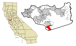
 Location in Contra Costa County and the state of California | ||
| Coordinates: 37°46′48″N 121°58′41″W / 37.78000°N 121.97806°W | ||
| Country | United States | |
| State | California | |
| County | Contra Costa | |
| Incorporated | July 1, 1983[1] | |
| • Mayor | Bill Clarkson[2] | |
| • State senator | Steve Glazer (D)[3] | |
| • Assemblymember | Catharine Baker (R)[4] | |
| • United States representatives[6] | Mark DeSaulnier (D) and Eric Swalwell (D)[5] | |
| • ആകെ | 18.64 ച മൈ (48.29 ച.കി.മീ.) | |
| • ഭൂമി | 18.63 ച മൈ (48.24 ച.കി.മീ.) | |
| • ജലം | 0.02 ച മൈ (0.04 ച.കി.മീ.) 0.09% | |
| ഉയരം | 486 അടി (148 മീ) | |
(2010) | ||
| • ആകെ | 72,148 | |
| • കണക്ക് (2016)[9] | 75,639 | |
| • ജനസാന്ദ്രത | 4,060.72/ച മൈ (1,567.81/ച.കി.മീ.) | |
| സമയമേഖല | UTC-8 (Pacific) | |
| • Summer (DST) | UTC-7 (PDT) | |
| ZIP codes[10] | 94582, 94583 | |
| Area code | 925 | |
| FIPS code | 06-68378 | |
| GNIS feature IDs | 1656275, 2411805 | |
| വെബ്സൈറ്റ് | www | |
അവലംബം
തിരുത്തുക- ↑ "California Cities by Incorporation Date". California Association of Local Agency Formation Commissions. Archived from the original (Word) on 2014-11-03. Retrieved March 27, 2013.
- ↑ "City Council". City of San Ramon. Retrieved March 27, 2013.
- ↑ "Senators". State of California. Retrieved March 27, 2013.
- ↑ "Members Assembly". State of California. Retrieved March 27, 2013.
- ↑ ഉദ്ധരിച്ചതിൽ പിഴവ്: അസാധുവായ
<ref>ടാഗ്;GovTrackഎന്ന പേരിലെ അവലംബങ്ങൾക്ക് എഴുത്തൊന്നും നൽകിയിട്ടില്ല. - ↑ "Communities of Interest - City". California Citizens Redistricting Commission. Archived from the original on 2013-09-30. Retrieved September 27, 2014.
- ↑ "2016 U.S. Gazetteer Files". United States Census Bureau. Retrieved Jun 28, 2017.
- ↑ "San Ramon". Geographic Names Information System. United States Geological Survey.
- ↑ ഉദ്ധരിച്ചതിൽ പിഴവ്: അസാധുവായ
<ref>ടാഗ്;USCensusEst2016എന്ന പേരിലെ അവലംബങ്ങൾക്ക് എഴുത്തൊന്നും നൽകിയിട്ടില്ല. - ↑ "ZIP Code(tm) Lookup". United States Postal Service. Retrieved November 23, 2014.

