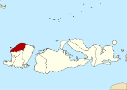
വടക്കൻ ലോംബോക്ക് റീജൻസി
വടക്കൻ ലോംബോക്ക് റീജൻസി (ഇന്തോനേഷ്യൻ: കബുപാറ്റെൻ ലോംബോക് ഉത്തര) ഇന്തോനേഷ്യയിലെ പ്രവിശ്യയായ പടിഞ്ഞാറൻ നുസാ തെൻഗാരയിലെ ഒരു റീജൻസിയാണ്. ലോംബോക്ക് ദ്വീപിന്റെ വടക്കൻ തീരത്തായി സ്ഥിതി ചെയ്യുന്ന ഈ റീജൻസിയുടെ തലസ്ഥാനം ടാൻജംഗ് ആണ്.
വടക്കൻ ലോംബോക്ക് റീജൻസി Kabupaten Lombok Utara | ||
|---|---|---|
| ||
| Motto(s): Tioq Tata Tunaq | ||
 Location within West Nusa Tenggara | ||
| Coordinates: 8°21′S 116°9′E / 8.350°S 116.150°E | ||
| Country | ||
| Province | ||
| Capital | Tanjung | |
| • Regent | Njamul Akhyar | |
| • Vice Regent | Sarifudin | |
| • ഭൂമി | 776.25 ച.കി.മീ.(299.71 ച മൈ) | |
| ഉയരം | max 3,726 മീ(12,224 അടി) | |
(2010 Census) | ||
| • ആകെ | 199,904 | |
| • Ethnic groups | Sasak, Balinese, Javanese, Sumbawa people, Flores people | |
| • Religion | Muslim, Hindu, Christian, Buddhist | |
| • Languages | Indonesian (official), Sasak | |
| സമയമേഖല | UTC+8 (ICST) | |
| Area code | (+62) 370 | |
| വെബ്സൈറ്റ് | lombokutarakab | |
സ്ഥാനം
തിരുത്തുകവടക്ക് വടക്ക് ജാവാ കടൽ, തെക്കുഭാഗത്ത് മധ്യ ലോംബോക്ക് റീജൻസി, പടിഞ്ഞാറൻ ലോംബോക്ക്, കിഴക്ക് ഭാഗത്ത് കിഴക്കൻ ലോംബോക്ക് റീജൻസി, പടിഞ്ഞാറ് ലോംബോക്ക് കടലിടുക്ക് എന്നിവയാൽ വലയം ചെയ്യപ്പെട്ടാണ് വടകക്കൻ ലോംബോക്ക് റീജൻസി നിലനിൽക്കുന്നത്. റീജൻസിയുടെ മദ്ധ്യഭാഗത്തായി ഇന്തോനേഷ്യയിലെ വലിപ്പത്തിൽ മാന്നാം സ്ഥാനത്തുള്ളതും രണ്ടാമത്തെ വലിയ അഗ്നിപർവ്വതവുമായ 3,726 മീറ്റർ (12,224 അടി) ഉയരമുള്ള റിൻജാനി കൊടുമുടി സ്ഥിതിചെയ്യുന്നു.[1] ഇതിന്റെ രേഖപ്പെടുത്തപ്പെട്ട ഏറ്റവും പഴയ ചരിത്രപരമായ സ്ഫോടനം 1847 ലും ഒടുവിലെ സ്ഫോടനം 2010 മെയ് മാസത്തിലുമായിരുന്നു.[2][3][4][5][6][7]
ജനസംഖ്യ
തിരുത്തുകഈ റീജൻസിയിലെ ജനസംഖ്യയിൽ ഭൂരിഭാഗവും സസക് ജനതയാണ്. 2010 ലെ സെൻസസ് പ്രകാരം വടക്കൻ ലോംബോക്ക് റീജൻസിയിൽ 199,904 നിവാസികളുണ്ടെന്ന് രേഖപ്പെടുത്തിയിരുന്നു.
അവലംബം
തിരുത്തുക- ↑ "Information - Rinjani". Global Vulcanism Program USGS-Smithsosian. Archived from the original on 2017-09-28. Retrieved 13 September 2010.
- ↑ "Mountains of the Indonesian Archipelago-92 Mountain Summits with Prominence of 1,500 meters or greater". Jonathan de Ferranti and Aaron Maizlish. 16 August 2005. Retrieved 13 September 2010.
- ↑ "Global Vulcanism Program-Rinjani Eruptive History". Global Vulcanism Program. 2 May – 20 December 2009. Archived from the original on 2007-08-20. Retrieved 10 May 2010.
- ↑ "Global Volcanism Program | Rinjani | SI / USGS Weekly Volcanic Activity Reports". Volcano.si.edu. Archived from the original on 2012-10-09. Retrieved 6 October 2010.
- ↑ "Pusat Vulkanologi & Mitigasi Bencana Geologi - VSI - Evaluasi Kegiatan G. Rinjani". Portal.vsi.esdm.go.id. 4 മേയ് 2010. Archived from the original on 17 ജൂലൈ 2010. Retrieved 6 ഒക്ടോബർ 2010.
- ↑ "SI / USGS Weekly Volcanic Activity Report-5–11 May 2010-RINJANI Lombok Island (Indonesia)". Global Volcanism Program. 5–11 May 2010. Archived from the original on 2021-03-02. Retrieved 17 May 2010.
- ↑ "Volcano erupts in Indonesia". Australian Broadcasting Commission-ABC Asia Pacific News Service. 24 May 2010. Archived from the original on 2011-07-17. Retrieved 24 May 2010.


