ലാറാമി നദി
ലാറാമി നദി യു.എസ്. സംസ്ഥാനങ്ങളായ കൊളറാഡോ, വയോമിങ് എന്നിവിടങ്ങളിലൂടെ ഒഴുകുന്ന ഏകദേശം 280 മൈൽ (450 കിലോമീറ്റർ)[5] നീളമുള്ള നോർത്ത് പ്ലാറ്റ് നദിയുടെ ഒരു കൈവഴിയാണ്. പത്തൊൻപതാം നൂറ്റാണ്ടിന്റെപ്രാരംഭത്തിൽ ഈ പ്രദേശം സന്ദർശിച്ച രോമ വ്യാപാരിയും കെണിക്കാരനായിരുന്ന ജാക്വസ് ലാ റാമിയുടെ പേരിലാണ് നദി അറിയപ്പെടുന്നത്. വയോമിങിലെ ലാറാമി കൗണ്ടി, ലാറാമി നഗരം, പ്രദേശത്തെ മറ്റ് ഭൂമിശാസ്ത്രപരമായ സ്ഥാപനങ്ങൾ എന്നിവയുടെ പേരിൽ "ലറാമി" എന്ന പേരുണ്ട്.
| ലാറാമി നദി | |
|---|---|
 The Laramie River, as it flows past the site of old Fort Laramie | |
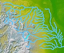
 Map highlighting the Laramie River (in bright blue, below and slightly left of center) | |
| ഉദ്ഭവം | Named for Jacques La Ramie, French Canadian fur trapper[1] |
| Country | United States |
| State | Colorado, Wyoming |
| Cities | Laramie, Wheatland, Fort Laramie |
| Physical characteristics | |
| പ്രധാന സ്രോതസ്സ് | Chambers Lake (Colorado) Larimer County, Colorado 9,192 അടി (2,802 മീ)[2] 40°36′56″N 105°51′29″W / 40.61556°N 105.85806°W |
| നദീമുഖം | North Platte River Goshen County, Wyoming 4,213 അടി (1,284 മീ)[3] 42°11′59″N 104°31′47″W / 42.19972°N 104.52972°W[3] |
| നീളം | 280 മൈ (450 കി.മീ) |
| Discharge | |
| നദീതട പ്രത്യേകതകൾ | |
| നദീതട വിസ്തൃതി | 4,564 ച മൈ ([convert: unknown unit])[4] |
| പോഷകനദികൾ |
|
അവലംബം
തിരുത്തുക- ↑ "Story Idea, Name Origins: Cheyenne & Laramie County". Visit Cheyenne. January 1, 2010. Archived from the original on August 28, 2013. Retrieved October 12, 2012.
- ↑ Source elevation derived from Google Earth search using GNIS source coordinates.
- ↑ 3.0 3.1 "Laramie River". Geographic Names Information System. United States Geological Survey. October 13, 1978. Archived from the original on 2021-06-11. Retrieved October 12, 2012.
- ↑ 4.0 4.1 4.2 "Water-Data Report 2011: 06670500 Laramie River near Fort Laramie, WY" (PDF). United States Geological Survey. Retrieved October 12, 2012.
- ↑ U.S. Geological Survey. National Hydrography Dataset high-resolution flowline data. The National Map Archived 2012-03-29 at the Wayback Machine., accessed March 21, 2011