യൂട്ടിക്ക
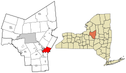
യൂട്ടിക്ക (/ˈjuːtɪkə/ ⓘ) മൊഹാവ്ക് താഴ്വരയിലെ ഒരു നഗരവും അമേരിക്കൻ ഐക്യനാടുകളിലെ ന്യൂയോർക്ക് സംസ്ഥാനത്തെ ഒനൈഡാ കൗണ്ടിയുടെ ആസ്ഥാനവുമായ നഗരമാണ്. 2010 ലെ യുഎസ് സെൻസസിൽ 62,235 ജനസംഖ്യയുള്ള ഈ നഗരം ന്യൂയോർക്കിലെ ഏറ്റവും ജനസംഖ്യയുള്ള പത്താമത്തെ നഗരമാണ്. അഡിറോണ്ടാക്ക് പർവതനിരകളുടെ താഴ്വരയിൽ മൊഹാവ്ക് നദിയോരത്തു സ്ഥിതിചെയ്യുന്ന യൂട്ടിക്ക, അൽബാനിക്ക് 95 മൈൽ (153 കിലോമീറ്റർ) വടക്കുപടിഞ്ഞാറായും സിറാക്കൂസിന് 55 മൈൽ (89 കിലോമീറ്റർ) കിഴക്കായും, ന്യൂയോർക്ക് നഗരത്തിന് 240 മൈൽ (386 കിലോമീറ്റർ) വടക്കുപടിഞ്ഞാറായുമാണ് സ്ഥിതിചെയ്യുന്നത്. യൂട്ടിക്കയും അടുത്തുള്ള റോം നഗരവും ചേർന്ന് രൂപപ്പെടുന്ന യൂട്ടിക്ക-റോം മെട്രോപൊളിറ്റൻ സ്റ്റാറ്റിസ്റ്റിക്കൽ ഏരിയയിൽ ഒനിഡ, ഹെർകിമർ കൗണ്ടികളും ഉൾപ്പെട്ടിരിക്കുന്നു.
യൂട്ടിക്ക | |||||||||
|---|---|---|---|---|---|---|---|---|---|
City | |||||||||
| |||||||||
| |||||||||
| Nickname(s): The Handshake City, Sin City, Elm Tree City[1] | |||||||||
 Location in Oneida County and New York | |||||||||
| Coordinates: 43°05′41″N 75°16′33″W / 43.09472°N 75.27583°W | |||||||||
| Country | |||||||||
| State | |||||||||
| Metro | Utica–Rome | ||||||||
| County | Oneida | ||||||||
| Land grant (village) | January 2, 1734ലുവ പിഴവ് ഘടകം:Footnotes-ൽ 80 വരിയിൽ : bad argument #1 to 'ipairs' (table expected, got nil) | ||||||||
| Incorporated (village) | April 3, 1798 | ||||||||
| Incorporated (city) | February 13, 1832ലുവ പിഴവ് ഘടകം:Footnotes-ൽ 80 വരിയിൽ : bad argument #1 to 'ipairs' (table expected, got nil) | ||||||||
| • Mayor | Robert M. Palmieri (D) | ||||||||
| • City | 17.02 ച മൈ (44.07 ച.കി.മീ.) | ||||||||
| • ഭൂമി | 16.76 ച മൈ (43.40 ച.കി.മീ.) | ||||||||
| • ജലം | 0.26 ച മൈ (0.66 ച.കി.മീ.) | ||||||||
| ഉയരം | 456 അടി (139 മീ) | ||||||||
| • City | 62,235 | ||||||||
| • കണക്ക് (2018) | 60,100 | ||||||||
| • ജനസാന്ദ്രത | 3,619.07/ച മൈ (1,397.36/ച.കി.മീ.) | ||||||||
| • നഗരപ്രദേശം | 117,328 (U.S.: 268th)[4] | ||||||||
| • മെട്രോപ്രദേശം | 297,592 (U.S.: 163rd)[3][a] | ||||||||
| Demonym(s) | Utican | ||||||||
| സമയമേഖല | UTC−5 (Eastern (EST)) | ||||||||
| • Summer (DST) | UTC−4 (EDT) | ||||||||
| ZIP codes | 13501-13505, 13599 | ||||||||
| ഏരിയ കോഡ് | 315 | ||||||||
| FIPS code | 36-76540 | ||||||||
| GNIS feature ID | 0968324[6] | ||||||||
| വെബ്സൈറ്റ് | cityofutica.com | ||||||||
മുമ്പ് ഇറോക്വോയിസ് കോൺഫെഡറസിയിലെ മൊഹാവ് ഗോത്രക്കാർ അധിവസിച്ചിരുന്ന ഒരു നദീതടമായിരുന്ന, യുട്ടിക്ക അമേരിക്കൻ വിപ്ലവകാലത്തും അതിനുശേഷവും ന്യൂ ഇംഗ്ലണ്ടിൽ നിന്നുള്ള യൂറോപ്യൻ-അമേരിക്കൻ കുടിയേറ്റക്കാരെ ആകർഷിച്ചു. പത്തൊൻപതാം നൂറ്റാണ്ടിൽ, ഈറി, ചെനങ്കോ കനാലുകൾ, ന്യൂയോർക്ക് സെൻട്രൽ റെയിൽറോഡ് എന്നീ അടിസ്ഥാന സൌകര്യങ്ങൾക്കു സമീപം ആൽബാനിക്കും സിറാക്കൂസിനും ഇടയിലുള്ള ഒരു ഇടനഗരമെന്ന നിലയിൽ കുടിയേറ്റക്കാർ അതിന്റെ സ്ഥാനം ശക്തിപ്പെടുത്തി. പത്തൊൻപതാം നൂറ്റാണ്ടിലും ഇരുപതാം നൂറ്റാണ്ടിലും നഗരത്തിന്റെ അടിസ്ഥാന സൌകര്യങ്ങളുടെ വികസം ഒരു ഉൽപാദന കേന്ദ്രമെന്ന നിലയിൽ അതിന്റെ വിജയത്തിന് കാരണമാവുകയും വസ്ത്രവ്യവസായത്തിന്റെ ലോകകേന്ദ്രമായി അതിന്റെ പങ്ക് നിർവചിക്കുകയും ചെയ്തു. യൂട്ടിക്കയുടെ ഇരുപതാം നൂറ്റാണ്ടിലെ രാഷ്ട്രീയ അഴിമതികളും സംഘടിത കുറ്റകൃത്യങ്ങളും ഇതിന് "സിൻ സിറ്റി" എന്ന വിളിപ്പേര് നൽകി.[7]
അവലംബം
തിരുത്തുക- ↑ Bottini, Joseph L.; Davis, James L. (2007). Utica. Arcadia Publishing. p. 90. ISBN 978-0-7385-5496-9.
- ↑ "2016 U.S. Gazetteer Files". United States Census Bureau. Retrieved July 5, 2017.
- ↑ "U.S. Census Bureau, 2011-2015 American Community Survey 5-Year Estimates". 2015 Population Estimates. United States Census Bureau, Population Division. Archived from the original on September 17, 2017. Retrieved April 20, 2017.
- ↑ "Census Urban Area List". United States Census Bureau. Archived from the original on March 28, 2012. Retrieved May 7, 2015.
- ↑ "Metropolitan and Micropolitan Statistical Areas". United States Census Bureau, Population Division. June 9, 2014. Archived from the original on June 27, 2014. Retrieved April 14, 2015.
- ↑ "Feature Detail Report for: Utica". United States Geological Survey. January 23, 1980. Archived from the original on 2022-05-30. Retrieved April 15, 2015.
- ↑ Schneider, Meg. New York Yesterday & Today. Voyageur Press. p. 101. ISBN 978-1-6167-3126-7.
കുറിപ്പുകൾ
തിരുത്തുക- ↑ Estimated MSA rank as of July 1, 2014.


