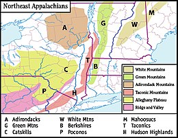
അഡിറോണ്ടാക്ക് പർവതനിരകൾ
അഡിറോണ്ടാക്ക് പർവതനിരകൾ (/ædɪˈrɒndæk/) അമേരിക്കൻ ഐക്യനാടുകളിലെ ന്യൂയോർക്ക് സംസ്ഥാനത്തിൻറെ വടക്കുകിഴക്കൻ മേഖലയിലെ ഒരു പർവ്വതനിരയാണ്. അതിന്റെ അതിരുകൾ ഏകദേശം അഡിറോണ്ടാക്ക് ഉദ്യാനത്തിൻറെ അതിർത്തികളോട് യോജിക്കുന്നു. ഈ പർവ്വതനിര ഏകദേശം 5,000 ചതുരശ്ര മൈൽ (13,000 ചതുരശ്ര കിലോമീറ്റർ) പ്രദേശത്തായിവ്യാപിച്ചുകിടക്കുന്നു.[1] പർവതങ്ങൾ ഏകദേശം 160 മൈൽ (260 കിലോമീറ്റർ) വ്യാസവും ഏകദേശം 1 മൈൽ (1,600 മീറ്റർ) ഉയരവുമുള്ള ഏതാണ്ട് വൃത്താകൃതിയിലുള്ള താഴികക്കുടത്തിന് സമാനമായി രൂപപ്പെട്ടിരിക്കുന്നു. ഹഡ്സൺ നദിയുടെ ഉറവിടമായ ജോർജ്ജ് തടാകം, പ്ലാസിഡ് തടാകം, ലേക് ടിയർ ഓഫ് ദി ക്ലൗഡ്സ് എന്നിവയുൾപ്പെടെ 200-ലധികം തടാകങ്ങൾ മലനിരകൾക്ക് ചുറ്റുപാടുമായുണ്ട്.[2] നൂറുകണക്കിന് പർവത ശിഖരങ്ങളുടെ കേന്ദ്രമായ അഡിറോണ്ടാക്ക് മേഖലയിലെ കൊടുമുടികളിൽ ചിലത് 5,000 അടി (1,500 മീറ്റർ) അല്ലെങ്കിൽ അതിൽ കൂടുതൽ ഉയരത്തിൽ എത്തുന്നവയാണ്.
| അഡിറോണ്ടാക്ക് പർവതനിരകൾ | |
|---|---|
 The Adirondack Mountains seen in winter | |
| ഉയരം കൂടിയ പർവതം | |
| Peak | Mount Marcy |
| Elevation | 1,629 മീ (5,344 അടി) |
| Listing | |
| Coordinates | 44°06′45″N 73°55′26″W / 44.11250°N 73.92389°W |
| ഭൂമിശാസ്ത്രപരമായ പ്രത്യേകതകൾ | |
| Country | United States |
| State | New York |
| ഭൂവിജ്ഞാനീയം | |
| Orogeny | Grenville Orogeny |
| Age of rock | Tonian |
അവലംബം
തിരുത്തുക- ↑ The Young people's encyclopedia of the United States. Shapiro, William E. Brookfield, Conn.: Millbrook Press. 1993. ISBN 1-56294-514-9. OCLC 30932823.
{{cite book}}: CS1 maint: others (link) - ↑ The Young people's encyclopedia of the United States. Shapiro, William E. Brookfield, Conn.: Millbrook Press. 1993. ISBN 1-56294-514-9. OCLC 30932823.
{{cite book}}: CS1 maint: others (link)
