ചിറ്റഗോങ്
ബംഗ്ലാദേശിലെ ഒരു പ്രധാന തുറമുഖ നഗരമാണ് ചിറ്റഗോങ്. ബംഗ്ലാദേശിലെ ഏറ്റവും വലിയ രണ്ടാമത്തെ നഗരവുമാണിത്. ചിറ്റഗോങ് ഡിവിഷന്റെ ഭരണ തലസ്ഥാനമാണിത്.
ചിറ്റഗോങ് ( ചറ്റോഗ്രാമ) | |
|---|---|
| രാജ്യം | ബംഗ്ലാദേശ് |
| ഡിവിഷൻ | ചിറ്റഗോങ് ഡിവിഷൻ |
| ജില്ല | ചിറ്റഗോങ് ജില്ല |
| Establishment | 1340[1] |
| Granted city status | 1863[2] |
| • City Mayor | M. Manzur Alam |
| • മെട്രൊപ്പോളിസ് | 168 ച.കി.മീ.(65 ച മൈ) |
(2008)[4] | |
| • മെട്രൊപ്പോളിസ് | 25,79,107 |
| • ജനസാന്ദ്രത | 15,351/ച.കി.മീ.(39,760/ച മൈ) |
| • മെട്രോപ്രദേശം | 5 680 000 (2,011e) |
| • Demonym | Chittagongians |
| സമയമേഖല | UTC+6 (BST) |
| Postal code | 4000 |
| GDP (2008) | $25.5 billion[5] |
| GDP growth (2008) | 6.3%[5] |
| Calling code | 31 |
| വെബ്സൈറ്റ് | Chittagong City Corporation |
ചരിത്രം
തിരുത്തുകഭൂമിശാസ്ത്രവും കാലാവസ്ഥയും
തിരുത്തുകട്രോപ്പിക്കൽ മൺസൂൺ കാലാവസ്ഥയാണിവിടെ കാണുന്നത്.[6] കർണ്ണഫൂലി നദിയുടെ തീരത്താണ് ചിറ്റഗോങ്22°22′0″N 91°48′0″E / 22.36667°N 91.80000°E. ആകെ വിസ്തീർണ്ണം157 ച. �കിലോ�ീ. (61 ച മൈ). മലനിരകളാൽ ചുറ്റപ്പെട്ടതാണീ നഗരം. ഇവിടെ കൃത്രിമ തടാകങ്ങൾ മാത്രമാണുള്ളത്.
| Chittagong പ്രദേശത്തെ കാലാവസ്ഥ | |||||||||||||
|---|---|---|---|---|---|---|---|---|---|---|---|---|---|
| മാസം | ജനു | ഫെബ്രു | മാർ | ഏപ്രി | മേയ് | ജൂൺ | ജൂലൈ | ഓഗ | സെപ് | ഒക് | നവം | ഡിസം | വർഷം |
| റെക്കോർഡ് കൂടിയ °C (°F) | 31.7 (89.1) |
33.9 (93) |
37.2 (99) |
38.9 (102) |
36.7 (98.1) |
36.7 (98.1) |
34.4 (93.9) |
33.9 (93) |
35.0 (95) |
34.4 (93.9) |
33.9 (93) |
31.1 (88) |
38.9 (102) |
| ശരാശരി കൂടിയ °C (°F) | 26.0 (78.8) |
28.0 (82.4) |
30.6 (87.1) |
31.8 (89.2) |
32.3 (90.1) |
31.5 (88.7) |
30.9 (87.6) |
31.1 (88) |
31.5 (88.7) |
31.5 (88.7) |
29.8 (85.6) |
27.0 (80.6) |
30.2 (86.4) |
| പ്രതിദിന മാധ്യം °C (°F) | 20.0 (68) |
22.1 (71.8) |
25.5 (77.9) |
27.6 (81.7) |
28.5 (83.3) |
28.4 (83.1) |
28.0 (82.4) |
28.1 (82.6) |
28.3 (82.9) |
27.8 (82) |
25.1 (77.2) |
21.3 (70.3) |
25.9 (78.6) |
| ശരാശരി താഴ്ന്ന °C (°F) | 13.9 (57) |
16.2 (61.2) |
20.3 (68.5) |
23.4 (74.1) |
24.7 (76.5) |
25.2 (77.4) |
25.1 (77.2) |
25.1 (77.2) |
25.1 (77.2) |
24.0 (75.2) |
20.3 (68.5) |
15.6 (60.1) |
21.6 (70.9) |
| താഴ്ന്ന റെക്കോർഡ് °C (°F) | 7.2 (45) |
7.8 (46) |
10.6 (51.1) |
15.0 (59) |
18.3 (64.9) |
20.0 (68) |
19.4 (66.9) |
22.2 (72) |
21.7 (71.1) |
16.7 (62.1) |
11.1 (52) |
8.3 (46.9) |
7.2 (45) |
| മഴ/മഞ്ഞ് mm (inches) | 5.6 (0.22) |
24.4 (0.961) |
54.7 (2.154) |
147.4 (5.803) |
298.6 (11.756) |
607.3 (23.909) |
727.0 (28.622) |
530.6 (20.89) |
259.3 (10.209) |
184.8 (7.276) |
67.5 (2.657) |
11.9 (0.469) |
2,919.1 (114.925) |
| ശരാ. മഴ/മഞ്ഞു ദിവസങ്ങൾ (≥ 0.1 mm) | 0 | 1 | 2 | 6 | 11 | 17 | 19 | 17 | 13 | 7 | 2 | 1 | 96 |
| % ആർദ്രത | 70 | 67 | 71 | 75 | 78 | 84 | 86 | 87 | 85 | 82 | 78 | 77 | 78 |
| Source #1: Weatherbase (normals, 30 yr period)[7] | |||||||||||||
| ഉറവിടം#2: Sistema de Clasificación Bioclimática Mundial (extremes),[8] BBC Weather (humidity and sun)[9] | |||||||||||||
ചിത്രശാല
തിരുത്തുക-
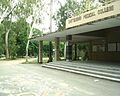 Chittagong Medical College entrance
 -
 View from DC hill, Chittagong
 -
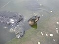
 Jafrabad shipbreaking yard, Chittagong
 -
 Potenga beach, Chittagong
 -
 Patenga beach in a cloudy weather
 -
 Biplob Udyan, Chittagong
 -
 Court Building of Chittagong
 -
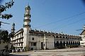 Andar Killa Mosque, Chittagong
 -
 Bostami Turtle, Shrine of Bayazid Bostami,Chittagong
 -
 War cemetery, Chittagong
 -
 Foy's Lake, Chittagong
 -
 Cheragi Pahar Circle, Chittagong
.jpg)

.JPG)
.jpg)


.JPG)


.JPG)
.JPG)
അവലംബം
തിരുത്തുക- ↑ List of cities and towns in Bangladesh, Retrieved 29 December 2009
- ↑ "History of Chittagong City Corporation". Chittagong City Corporation. Archived from the original on 2013-08-13. Retrieved 2013-05-26.
- ↑ "Area, Population and Literacy Rate by Paurashava –2001" (PDF). Bangladesh Bureau of Statistics. Archived from the original (PDF) on 2008-12-17. Retrieved 2009-09-18.
- ↑ "Statistical Pocket Book, 2008" (PDF). Bangladesh Bureau of Statistics. Archived from the original (PDF) on 2010-02-15. Retrieved 2009-08-15.
- ↑ 5.0 5.1 City Mayors: Richest cities in the world in 2020 by GDP
- ↑ Peel, M. C. and Finlayson, B. L. and McMahon, T. A. (2007). "Updated world map of the Köppen–Geiger climate classification" (PDF). Hydrol. Earth Syst. Sci. 11: 1633–1644. doi:10.5194/hess-11-1633-2007. ISSN 1027-5606.
{{cite journal}}: CS1 maint: multiple names: authors list (link) CS1 maint: unflagged free DOI (link) - ↑ "Weatherbase: Historical Weather for Chittagong, Bangladesh". Weatherbase. Archived from the original on 2019-01-07. Retrieved February 23, 2013.
- ↑ "Bangladesh - Chittagong" (in സ്പാനിഷ്). Centro de Investigaciones Fitosociológicas. Archived from the original on 2019-01-07. Retrieved February 23, 2013.
- ↑ "Average Conditions - Bangladesh - Chittagong". BBC. Retrieved February 23, 2013.
പുറം കണ്ണികൾ
തിരുത്തുക- Official Web Portal of Chittagong District Archived 2011-12-24 at the Wayback Machine.
Chittagong എന്ന വിഷയവുമായി ബന്ധപ്പെട്ട ചിത്രങ്ങൾ വിക്കിമീഡിയ കോമൺസിലുണ്ട്.
![]() വിക്കിവൊയേജിൽ നിന്നുള്ള ചിറ്റഗോങ് യാത്രാ സഹായി
വിക്കിവൊയേജിൽ നിന്നുള്ള ചിറ്റഗോങ് യാത്രാ സഹായി