ഗ്രീൻലാൻഡ് കടൽ
കടൽ
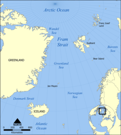
ആർട്ടിക് സമുദ്രത്തിലെ ഒരു കടലാണ് ഗ്രീൻലാൻഡ് കടൽ (Greenland Sea)[1][2][3] ചിലപ്പോൾ അറ്റ്ലാന്റിക് സമുദ്രത്തിന്റെ ഭാഗമായും കണക്കാക്കുന്നു.[4]പടിഞ്ഞാറ് ഗ്രീൻലാൻഡ് കിഴക്ക് സ്വാൽബാഡ് ദ്വീപസമൂഹം, ഫ്രാം കടലിടുക്ക് വടക്ക് ആർട്ടിക് സമുദ്രം തെക്ക് നോർവീജിയൻ കടൽ ഐസ്ലാന്റ് എന്നിവയ്ക്കിടയിൽ സ്ഥിതിചെയ്യുന്നു.
| ഗ്രീൻലാൻഡ് കടൽ | |
|---|---|
 ഗ്രീൻലാൻഡ് കടലിലെ മഞ്ഞുമല | |
 | |
| സ്ഥാനം | വടക്കൻ അമേരിക്ക കൂടാതെ വടക്കൻ യൂറോപ്പ് |
| നിർദ്ദേശാങ്കങ്ങൾ | 76°N 8°W / 76°N 8°W |
| Type | കടൽ |
| Basin countries | ഗ്രീൻലാൻഡ്, ഐസ്ലാൻഡ്, കൂടാതെ നോർവേ |
| ഉപരിതല വിസ്തീർണ്ണം | 1,205,000 കി.m2 (465,300 ച മൈ) |
| ശരാശരി ആഴം | 1,444 മീ (4,738 അടി) |
| പരമാവധി ആഴം | 4,846 മീ (15,899 അടി) |
| Water volume | 1,747,250 കി.m3 (419,000 cu mi) |
| അവലംബം | [1][2] |
അവലംബം
തിരുത്തുക- ↑ 1.0 1.1 "Greenland Sea" (in റഷ്യൻ). Great Soviet Encyclopedia. Archived from the original on 14 May 2013. Retrieved 5 September 2010.
- ↑ 2.0 2.1 "Greenland Sea". Encyclopædia Britannica on-line.
- ↑ Greenland Sea, MarBEF Data System – European Marine Gazetteer
- ↑ Reddy, M. P. M. (2001). Descriptive Physical Oceanography. Taylor & Francis. p. 8. ISBN 978-90-5410-706-4. Retrieved 26 November 2010.
