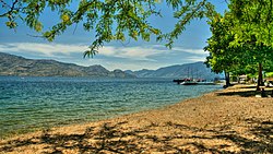
ഒകനാഗൻ തടാകം
ഒകനാഗൻ തടാകം (Okanagan: kɬúsx̌nítkw)[3] കാനഡയിലെ ബ്രിട്ടീഷ് കൊളംബിയ പ്രവിശ്യയിലെ ഒകനാഗൻ താഴ്വരയിലുള്ള ഒരു തടാകമാണ്. തടാകത്തിന് 135 കിലോമീറ്റർ (84 മൈൽ) നീളവും 4 മുതൽ 5 കിലോമീറ്റർ (2.5 മുതൽ 3.1 മൈൽ) വരെ വീതിയും കൂടാതെ 348 ചതുരശ്ര കിലോമീറ്റർ (135 ചതുരശ്ര മൈൽ) ഉപരിതല വിസ്തൃതിയുമുണ്ട്.[4][5][6]
| ഒകനാഗൻ തടാകം kɬúsx̌nítkw | |
|---|---|
 | |
| സ്ഥാനം | ബ്രിട്ടീഷ് കൊളംബിയ, കാനഡ |
| നിർദ്ദേശാങ്കങ്ങൾ | 49°54′40″N 119°30′45″W / 49.91111°N 119.51250°W |
| Lake type | Fjord Lake,[1] Monomictic, Oligotrophic |
| പ്രാഥമിക അന്തർപ്രവാഹം | Mission Creek, Vernon Creek, Trout Creek, Penticton Creek, Equesis Creek, Kelowna Creek, Peachland Creek, Powers Creek, Whiteman Creek |
| Primary outflows | ഒകനാഗൻ നദി |
| Catchment area | 6,200 കി.m2 (6.7×10¹⁰ sq ft) |
| Basin countries | Canada |
| പരമാവധി നീളം | 135 കിലോമീറ്റർ (84 മൈ) |
| പരമാവധി വീതി | 5 കിലോമീറ്റർ (3.1 മൈ) |
| Surface area | 351 ച. �കിലോ�ീ. (136 ച മൈ) |
| ശരാശരി ആഴം | 76 മീ (249 അടി) |
| പരമാവധി ആഴം | 232 മീ (761 അടി) |
| Water volume | 24.6 ഘനകിലോ മീറ്റർ (5.9 cu mi) |
| Residence time | 52.8 years |
| തീരത്തിന്റെ നീളം1 | 270 കിലോമീറ്റർ (170 മൈ) |
| ഉപരിതല ഉയരം | 342 മീ (1,122 അടി) |
| Frozen | 1906/07 & 1949/50 |
| Islands | Rattlesnake Island, Grant Island |
| അധിവാസ സ്ഥലങ്ങൾ | വെർനോൺ, ലേക്ക് കൌണ്ടി, കെലോവ്ന, വെസ്റ്റ് കെലോനa, പീച്ച്ലാൻഡ്, സമ്മർലാൻഡ്, പെന്റിക്റ്റൺ |
| അവലംബം | [2] |
| 1 Shore length is not a well-defined measure. | |
അവലംബം
തിരുത്തുക- ↑ Eyles, N., Mullins, H.T., and Hine, A.C. (1990). "Thick and fast: Sedimentation in a Pleistocene fiord lake of British Columbia, Canada". Geology. 18 (11): 1153–1157. Bibcode:1990Geo....18.1153E. doi:10.1130/0091-7613(1990)018<1153:TAFSIA>2.3.CO;2.
{{cite journal}}: CS1 maint: multiple names: authors list (link) - ↑ "Okanagan Lake". BC Geographical Names.
- ↑ "kɬúsx̌nítkʷ (Okanagan Lake) Responsibility Planning Initiative". Syilx Okanagan Nation Alliance. Okanagan Nation Alliance. Retrieved 20 March 2022.
- ↑ Limnology of the Major Lakes in the Okanagan Basin. Canada - British Columbia Okanagan Basin Agreement, Final Report, Technical Supplement V. (PDF) (Report). Penticton, British Columbia: British Columbia Water Resources Service. April 1974. p. 46. Archived from the original (PDF) on 2016-03-04. Retrieved 2015-10-22.
Okanagan Lake surface area: 348 * 106 m2. Dat compiled by the charts of the Fish and Wildlife Branch, Department of Recreation and Conservation, BC.
- ↑ Stockner J.G.; Northcote T.G. (1974). "Recent limnological studies of Okanagan Basin lakes and their contribution to comprehensive water resource planning". Journal of the Fisheries Research Board of Canada. 31 (5): 955–976. doi:10.1139/f74-111.
- ↑ "Okanagan Lake". World Lakes Database. International Lake Environment Committee Foundation. Archived from the original on 2005-11-21. Retrieved 2006-05-12.
