ബാൻഡെലിയർ ദേശീയ സ്മാരകസൗധം
(Bandelier National Monument എന്ന താളിൽ നിന്നും തിരിച്ചുവിട്ടതു പ്രകാരം)
അമേരിക്കൻ ഐക്യനാടുകളിൽ ന്യൂ മെക്സിക്കോ സംസ്ഥാനത്ത് 33,677-ഏക്കർ (13,629 ഹെ) വരുന്ന ദേശീയ സ്മാരകസൗധമാണ് ബാൻഡെലിയർ ദേശീയ സ്മാരകസൗധം. 1150 മുതൽ 1600 വരെയുള്ള രണ്ട് കാലഘട്ടത്തിൽ നിർമ്മിക്കപ്പെട്ട പൂബ്ലോ ആദിവാസികളുടെ വീടുകളാണ് ഇവിടെ സംരക്ഷിച്ച് നിലനിർത്തിയിരിക്കുന്നത്. പജാരിറ്റോ പീഠഭൂമിയിലെ 50 ചതുരശ്ര മൈൽ (130 ചതുശ്ര കിലോമീറ്റർ) പ്രദേശത്തായി വ്യാപിച്ചുകിടക്കുന്ന ഈ സ്മാരകം, ജെമെസ് പർവതനിരകളിലെ ജെമെസ് അഗ്നിപർവ്വത മേഖലയുടെ ചരിവുകളിലാണ് സ്ഥിതിചെയ്യുന്നത്.
| ബാൻഡെലിയർ ദേശീയ സ്മാരകസൗധം | |
|---|---|
ഐ.യു.സി.എൻ. ഗണം V (Protected Landscape/Seascape) | |
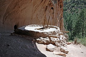
 Reconstructed kiva at Alcove House | |
| Location | Sandoval, Los Alamos and Santa Fe counties, New Mexico, United States |
| Nearest town | ലോസ് അലാമോസ്, ന്യൂ മെക്സിക്കോ |
| Coordinates | 35°46′44″N 106°19′16″W / 35.77889°N 106.32111°W[1] |
| Area | 33,677 ഏക്കർ (136.29 കി.m2)[2] |
| Created | ഫെബ്രുവരി 11, 1916 |
| Visitors | 200,741 (in 2019)[3] |
| Governing body | നാഷണൽ പാർക്ക് സർവീസ് |
| Website | Bandelier National Monument |
ബാൻഡെലിയർ ദേശീയ സ്മാരകസൗധം | |
| Built | 1200 |
| NRHP reference # | 66000042[4] (original) 14001017[5] (increase) |
| {{{DESIGNATED_OTHER1_ABBR}}} # | 56 |
| Significant dates | |
| Added to NRHP | October 15, 1966 |
| Boundary increase | December 10, 2014 |
| Designated {{{DESIGNATED_OTHER1_ABBR}}} | May 21, 1971 |
അവലംബം
തിരുത്തുക- ↑ "Bandelier National Monument". Geographic Names Information System. United States Geological Survey. Retrieved November 18, 2013.
- ↑ "Listing of acreage as of December 31, 2011". Land Resource Division, National Park Service. Retrieved 2012-03-12.
- ↑ "Annual Visitation Report by Years: 2009 to 2019". nps.gov. National Park Service. Retrieved 16 August 2020.
- ↑ "National Register Information System". National Register of Historic Places. National Park Service. 2010-07-09.
- ↑ "Weekly List of Actions Taken on Properties: 12/08/14 through 12/12/14". National Park Service. December 19, 2014.
{{cite web}}: Missing or empty|url=(help)

