റിച്ച്മണ്ട്, വിർജീനിയ
റിച്ച്മോണ്ട് (/ˈrɪtʃmənd/ RICH-mənd) യു.എസ്. സംസ്ഥാനമായ കോമൺവെൽത്ത് വിർജീനിയുടെ തലസ്ഥാനമാണ്. റിച്ച്മോണ്ട് മെട്രോപോളിറ്റൻ സ്റ്റാറ്റിസ്റ്റിക്കൽ മേഖലയുടെയും ഗ്രേറ്റർ റിച്ച്മോണ്ട് മേഖലയുടെയും കേന്ദ്രഭാഗമാണിത്. 1742 ൽ സംയോജിപ്പിക്കപ്പെട്ട ഈ പട്ടണം 871 മുതൽ ഒരു സ്വതന്ത്ര പട്ടണമാണ്. 2010 ലെ സെൻസസ് അനുസരിച്ച് ഈ പട്ടണത്തിലെ ജനസംഖ്യ 204,214 ആണ്. വിർജീനിയ സംസ്ഥാനത്തെ നാലാമത്തെ ജനസാന്ദ്രത കൂടിയ പട്ടണമാണിത്. റിച്ച്മോണ്ട് മെട്രോപോളിറ്റൺ മേഖലയിലെ ആകെ ജനസംഖ്യ 1,260,029 ആണ്. ഇത് സംസ്ഥാനത്തെ ജനസംഖ്യ കൂടിയ മെട്രോ പട്ടണങ്ങളിൽ റിച്ച്മോണ്ടിനെ മൂന്നാം സ്ഥാനത്തു നിറുത്തുന്നു.
റിച്ച്മണ്ട്, വിർജീനിയ | ||
|---|---|---|
| City of Richmond | ||
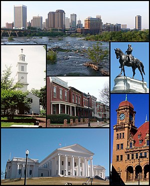
 Top: Skyline above the falls of the James River Middle: St. John's Episcopal Church, Jackson Ward, Monument Avenue. Bottom: Virginia State Capitol, Main Street Station | ||
| ||
| Nickname(s): | ||
| Motto(s): Sic Itur Ad Astra ("Thus do we reach the stars") | ||
 Location in the Commonwealth of Virginia | ||
| Country | United States | |
| State | ||
| County | None (Independent city) | |
| • Mayor | Dwight Clinton Jones (D) | |
| • City | 62.5 ച മൈ (162 ച.കി.മീ.) | |
| • ഭൂമി | 60.1 ച മൈ (156 ച.കി.മീ.) | |
| • ജലം | 2.5 ച മൈ (6 ച.കി.മീ.) | |
| ഉയരം | 166.45 അടി (45.7 മീ) | |
(2015) | ||
| • City | 220,289 (98th) | |
| • ജനസാന്ദ്രത | 3,625/ച മൈ (1,400/ച.കി.മീ.) | |
| • മെട്രോപ്രദേശം | 1,260,029 (44th) | |
| Demonym(s) | Richmonder | |
| സമയമേഖല | UTC-5 (EST) | |
| • Summer (DST) | UTC-4 (EDT) | |
| ZIP Codes | 23173, 23218–23242, 23249–23250, 23255, 23260–23261, 23269, 23273–23274, 23276, 23278–23279, 23282, 23284–23286, 23288–23295, 23297–23298 | |
| Area code | 804 | |
| FIPS code | 51-67000[5] | |
| GNIS feature ID | 1499957[6] | |
| വെബ്സൈറ്റ് | www.ci.richmond.va.us | |
1071 to 1501 – Richmond: a castle town in Yorkshire, UK. 1501 to 1742 – Richmond, a palace town in Surrey, UK. 1742 to present – Richmond, Virginia. | ||
റിച്ചമോണ്ട് പട്ടണം, ജയിംസ് നദീ തടത്തിൽ വില്ല്യംബർഗ്ഗിന് 44 മൈൽ (71 കി.മീ.) പടിഞ്ഞാറായും ചാർലെറ്റ്സ് വില്ലെയ്ക്കു 66 മൈൽ (106 കി.മീ.) കിഴക്കായും വാഷിംഗ്ടൺ ടി.സിയ്ക്കു 98 മൈൽ (158 കി.മീ.) തെക്കു ഭാഗത്തുമായാണ് സ്ഥിതി ചെയ്യുന്നത്. ഹെന്റിക്കോ, ചെസ്റ്റർഫീൽഡ് എന്നീ കൌണ്ടികൾ പട്ടണത്തെ വലയം ചെയ്യുന്നു. ഇൻറർസ്റ്റേറ്റ് 95, ഇൻറർസ്റ്റേറ്റ് 64, എന്നീ ഹൈവേകൾ നഗരത്തിലൂടെ പരസ്പരം ഛേദിച്ചു കടന്നു പോകുന്നിടത്തായാണ് പട്ടണം. ഇൻറർസ്റ്റേറ്റ് 295, വിർജീനിയ സ്റ്റേറ്റ് റൂട്ട് 288 എന്നീ ഹൈവേകൾ പട്ടണത്തെ വലയം ചെയ്താണു കടന്നു പോകുന്നത്. നഗരാതിർത്തിക്കു പുറത്തുള്ള പ്രദേശങ്ങൾ തെക്കുപടിഞ്ഞാറ് മിഡ്ലോത്തിയൻ വടക്കും പടിഞ്ഞാറും ഗ്ലൻ അല്ലെൻ പടിഞ്ഞാറ് ഷോർട്ട് പമ്പ്, വട്ക്കുകിഴക്ക് മെക്കാനിക് വില്ലെ എന്നിവയാണ്.
അവലംബം
തിരുത്തുക- ↑ City Connection, Office of the Press Secretary to the Mayor. Richmondgov.com Archived 2011-09-30 at the Wayback Machine.. January–March 2010 edition. Retrieved February 8, 2010.
- ↑ TOLLET, DRAD. "RVAMag." rvamag.com March 20, 2013. [1].
- ↑ Civil War Richmond – The South's Capital – Virginia Is For Lovers Archived 2016-01-11 at the Wayback Machine.. Virginia.org (2012-05-18). Retrieved on 2013-08-21.
- ↑ Griset, Rich. (2013-08-09) One of the most extensive collections of Eskimo folk art is right here in Richmond. Archived 2015-07-01 at the Wayback Machine.. Style Weekly. Retrieved on 2013-08-21.
- ↑ "American FactFinder". United States Census Bureau. Archived from the original on സെപ്റ്റംബർ 11, 2013. Retrieved ജനുവരി 31, 2008.
- ↑ "US Board on Geographic Names". United States Geological Survey. ഒക്ടോബർ 25, 2007. Retrieved ജനുവരി 31, 2008.