ബേക്കേർസ്ഫീൽഡ്
ബേക്കർസ്ഫീൽഡ്, അമേരിക്കൻ ഐക്യനാടുകളിലെ കാലിഫോർണിയ സംസ്ഥാനത്തെ, കെൺ കൗണ്ടിയുടെ ആസ്ഥാനമായ നഗരമാണ്. സാൻ ജോവാക്വിൻ താഴ്വരയുടെയും സെൻട്രൽ വാലി മേഖലയുടെയും തെക്കേ അറ്റത്തിനു സമീപം ഏതാണ്ട് 142 ചതുരശ്ര മൈൽ (370 ചതുരശ്ര കിലോമീറ്റർ) വിസ്തൃതിയാണ് ഈ നഗരം സ്ഥിതിചെയ്യുന്നത്. ഏകദേശം 365,000 ജനങ്ങൾ അധിവസിക്കുന്ന ഇത് കാലിഫോർണിയയിലെ ഏറ്റവും ജനസംഖ്യയുള്ള ഒൻപതാമത്തെ നഗരവും അമേരിക്കൻ ഐക്യനാടുകളിലെ 52 ആമത്തെ ജനസാന്ദ്രതയുള്ള നഗരവുമാണ്. കെൺ കൌണ്ടി മുഴുവനായി ഉൾക്കൊള്ളുന്ന ബേക്കർസ്ഫീൽഡ്-ഡിലാനോ മെട്രോപോളിറ്റൻ സ്റ്റാറ്റിസ്റ്റിക്കൽ മേഖലയിലെ 2010 ലെ സെൻസസ് പ്രകാരമുള്ള ജനസംഖ്യ 839,631 ആണ്. ഇത് അമേരിക്കൻ ഐക്യനാടുകളിൽ വലിപ്പത്തിൽ 62 ആം സ്ഥാനമുള്ള മെട്രോപോളിറ്റൻ മേഖലയാണ്. നഗരപ്രാന്തത്തിലെ കിഴക്കൻ ബേക്കർസ്ഫീൽഡ്, ഓയിൽഡേൽ, റോസ്ഡേൽ തുടങ്ങിയ ബേക്കർസ്ഫീൽഡിനോടു കൂടുതലായി കൂട്ടിച്ചേർക്കപ്പെട്ട പ്രദേശങ്ങളിൽ ഏകദേശം 464,000 ജനസംഖ്യയുണ്ട്.
ബേക്കർസ്ഫീൽഡ്, കാലിഫോർണിയ | ||||||
|---|---|---|---|---|---|---|
| City of Bakersfield | ||||||
| ||||||
| ||||||
| Nickname(s): "Nashville West"[1] | ||||||
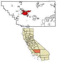
 Location of Bakersfield in Kern County, California. | ||||||
| Coordinates: 35°22′N 119°1′W / 35.367°N 119.017°W | ||||||
| Country | United States of America | |||||
| State | California | |||||
| County | Kern | |||||
| Region | San Joaquin Valley | |||||
| Incorporated | 1873–1876[2] | |||||
| Re-incorporated | January 11, 1898[3] | |||||
| നാമഹേതു | Thomas Baker | |||||
| • ഭരണസമിതി | Bakersfield City Council | |||||
| • Mayor | Karen K. Goh[4] | |||||
| • City Manager | Alan Tandy[5] | |||||
| • Finance director | Nelson Smith[6] | |||||
| • City clerk | Roberta Gafford[അവലംബം ആവശ്യമാണ്] | |||||
| • City | 151.06 ച മൈ (391.24 ച.കി.മീ.) | |||||
| • ഭൂമി | 149.59 ച മൈ (387.43 ച.കി.മീ.) | |||||
| • ജലം | 1.47 ച മൈ (3.81 ച.കി.മീ.) 0.97% | |||||
| • നഗരം | 138.44 ച മൈ (358.6 ച.കി.മീ.) | |||||
| • മെട്രോ | 8,161.42 ച മൈ (21,138.0 ച.കി.മീ.) | |||||
| ഉയരം | 404 അടി (123 മീ) | |||||
| • City | 3,47,483 | |||||
| • കണക്ക് (2016)[10] | 3,76,380 | |||||
| • റാങ്ക് | 1st in Kern County 9th in California 52nd in the United States | |||||
| • ജനസാന്ദ്രത | 2,516.01/ച മൈ (971.44/ച.കി.മീ.) | |||||
| • നഗരപ്രദേശം | 523,994 | |||||
| • നഗര സാന്ദ്രത | 3,800/ച മൈ (1,500/ച.കി.മീ.) | |||||
| • മെട്രോപ്രദേശം | 839,631 | |||||
| • മെട്രോ സാന്ദ്രത | 100/ച മൈ (40/ച.കി.മീ.) | |||||
| Demonym(s) | Bakersfieldian | |||||
| സമയമേഖല | UTC−8 (Pacific) | |||||
| • Summer (DST) | UTC−7 (PDT) | |||||
| ZIP codes | 93220, 93241, 93301–93309, 93311–93314, 93263, 93380–93390, 93399 | |||||
| Area code | 661 | |||||
| FIPS code | 06-03526 | |||||
| GNIS feature IDs | 1652668, 2409774 | |||||
| വെബ്സൈറ്റ് | www | |||||
കൃഷി, എണ്ണ ഉത്പാദനവും എന്നിവയുടെ ഒരു പ്രധാന കേന്ദ്രമാണിത്. രാജ്യത്ത് ഏറ്റവുമധികം എണ്ണ ഉത്പാദിപ്പിക്കുന്ന കൗണ്ടി എന്നതിനൊപ്പം അമേരിക്കൻ ഐക്യനാടുകളിലെ നാലാമത്തെ ഏറ്റവും മികച്ച കാർഷിക കൌണ്ടിയുമാണിത്. പ്രകൃതിവാതകം, മറ്റ് ഊർജ്ജ ഉൽപ്പാദന സംവിധാനങ്ങൾ, വിമാനനിർമ്മാണ വ്യവസായം , ഖനനം, പെട്രോളിയം സംസ്കരണം, ഉൽപ്പന്നങ്ങളുടെ നിർമ്മാണവും വിതരണവും, ഭഷ്യ സംസ്കരണം, കോർപ്പറേറ്റ് പ്രാദേശിക ഓഫീസുകൾ എന്നിവയാണ് ഇവിടുത്തെ വ്യാപാര വ്യവസായങ്ങളിൽ പ്രമുഖമായവ.
അവലംബം
തിരുത്തുക- ↑ Rachel Rubin; Jeffrey Paul Melnick (June 2001). American Popular Music: New Approaches to the Twentieth Century. University of Massachusetts Press. p. 94. ISBN 978-1-55849-268-4.
- ↑ Bailey, Richard (1984). Heart of the Golden Empire – An Illustrated History of Bakersfield. Woodland Hills, California: Windsor Publications, Inc. pp. 45, 51. ISBN 0-89781-065-1.
- ↑ "California Cities by Incorporation Date". California Association of Local Agency Formation Commissions. Archived from the original (Word) on November 3, 2014. Retrieved August 25, 2014.
- ↑ "Mayor's Office". City of Bakersfield. City of Bakersfield. Retrieved October 15, 2015.
- ↑ "City Manager's Office". City of Bakersfield. City of Bakersfield. Archived from the original on 2017-11-09. Retrieved October 15, 2015.
- ↑ "Finance Department". City of Bakersfield. City of Bakersfield. Archived from the original on 2018-01-05. Retrieved October 15, 2017.
- ↑ "2016 U.S. Gazetteer Files". United States Census Bureau. Retrieved Jul 19, 2017.
- ↑ "Bakersfield". Geographic Names Information System. United States Geological Survey.
- ↑ "Bakersfield (city) QuickFacts". United States Census Bureau. Archived from the original on August 16, 2012. Retrieved March 31, 2015.
- ↑ ഉദ്ധരിച്ചതിൽ പിഴവ്: അസാധുവായ
<ref>ടാഗ്;USCensusEst2016എന്ന പേരിലെ അവലംബങ്ങൾക്ക് എഴുത്തൊന്നും നൽകിയിട്ടില്ല. - ↑ •Urban and Rural Classification. US Census. 2010 Census. Accessed: April 5, 2012.
- ↑ "Kern County QuickFacts". United States Census Bureau. Archived from the original on July 13, 2011. Retrieved March 31, 2015.


