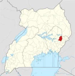
ബുകെഡിയ
ഉഗാണ്ടയിലെ കിഴക്കൻ മേഖലയിലെ ഒരു ജില്ലയാണ്,ബുകെഡിയ ജില്ല (Bukedea District) .
ബുകെഡിയ | |
|---|---|
ജില്ല | |
 ഉഗാണ്ടയിലെ സ്ഥാനം | |
| Coordinates: 01°21′N 34°03′E / 1.350°N 34.050°E | |
| രാജ്യം | |
| മേഖല | കിഴക്കൻ മേഖല, ഉഗാണ്ട |
| ഉപ മേഖല | ടെസൊ ഉപമേഖല |
| തലസ്ഥാനം | ബുകെഡിയ |
| • ഭൂമി | 1,051.7 ച.കി.മീ.(406.1 ച മൈ) |
(2012 ഏകദേശം) | |
| • ആകെ | 1,86,400 |
| • ജനസാന്ദ്രത | 177.2/ച.കി.മീ.(459/ച മൈ) |
| സമയമേഖല | UTC+3 ((EAT)) |
| വെബ്സൈറ്റ് | bukedea.go.ug |
സ്ഥാനം
തിരുത്തുകകുമി ജില്ല പടിഞ്ഞാറും വടക്കും [[ബുലംബുലി ജില്ല കിഴക്കും സൊറൊങ്കൊ ജില്ലയും മ്ബലെ ജില്ല തെക്കു കിഴക്കും പല്ലിസ ജില്ല തെക്കും അതിരുകളാണ്. ജില്ല ആസ്ഥാനമായ ബുകെഡിയ. ജില്ല ആസ്ഥാനംThe district headquarters at Bukedea are approximately 79 കിലോമീറ്റർ (49 മൈ), by road, south-east of Soroti, the largest city in the Teso sub-region.[1]
2006ജൂലൈ 13 ൽ പാസ്സാക്കിയ പാർലമെന്റ് നിയമപ്രകാരം 2007 ജൂലൈ 1ൻ നിലവിൽ വന്നതാണ് ഈ ജില്ല[2]അതിനുമുമ്പ് കുമി ജില്ല യുടെ ഭാഗമായിരുന്നുBefore that, the district was part of Kumi District.[3]
കുറിപ്പുകൾ
തിരുത്തുക- ↑ "Road Distance Between Soroti And Bukedea With Map". Globefeed.com. Retrieved 17 May 2014.
- ↑ Statoids. 30 June 2015 http://www.statoids.com/uug.html. Retrieved 5 March 2016.
{{cite web}}: Missing or empty|title=(help) - ↑ "ആർക്കൈവ് പകർപ്പ്". Commonwealth Network. Nexus Strategic Partnerships Limited. Archived from the original on 2016-03-07. Retrieved 5 March 2016.
പുറത്തേക്കുള്ള കണ്ണികൾ
തിരുത്തുക- Bukedea District Boss Accuses NRM of Abandoning Ideologies Archived 2016-03-03 at the Wayback Machine.