പ്രമാണം:Old Harbor Alaska aerial view.jpg

ഈ പ്രിവ്യൂവിന്റെ വലിപ്പം: 633 × 599 പിക്സലുകൾ. മറ്റ് റെസലൂഷനുകൾ: 254 × 240 പിക്സലുകൾ | 507 × 480 പിക്സലുകൾ | 811 × 768 പിക്സലുകൾ | 1,082 × 1,024 പിക്സലുകൾ | 1,500 × 1,420 പിക്സലുകൾ.
പൂർണ്ണ വലിപ്പം (1,500 × 1,420 പിക്സൽ, പ്രമാണത്തിന്റെ വലിപ്പം: 747 കെ.ബി., മൈം തരം: image/jpeg)
| ഈ പ്രമാണം വിക്കിമീഡിയ കോമൺസിൽ നിന്നുള്ളതാണ്. പ്രമാണത്തെക്കുറിച്ചുള്ള വിവരണം താഴെ കൊടുത്തിരിക്കുന്നു.
|
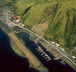
| വിവരണം | Aerial view of Old Harbor, Kodiak Island, Alaska, USA. | |||
| സ്ഥാനം | Old Harbor, Kodiak Island, Alaska, USA 57°11′50″N 153°18′28″W / 57.1972°N 153.30778°W |
|||
| തീയതി | not specified | |||
| സ്രോതസ്സ് |
U.S. Army Corps of Engineers Digital Visual Library Image page Image description page Digital Visual Library home page |
|||
| സ്രഷ്ടാവ് | U.S. Army Corps of Engineers, photographer unknown | |||
| അനുമതി (ഈ പ്രമാണത്തിന്റെ പുനരുപയോഗം) |
|
പ്രമാണ നാൾവഴി
ഏതെങ്കിലും തീയതി/സമയ കണ്ണിയിൽ ഞെക്കിയാൽ പ്രസ്തുതസമയത്ത് ഈ പ്രമാണം എങ്ങനെയായിരുന്നു എന്നു കാണാം.
| തീയതി/സമയം | ലഘുചിത്രം | അളവുകൾ | ഉപയോക്താവ് | അഭിപ്രായം | |
|---|---|---|---|---|---|
| നിലവിലുള്ളത് | 05:08, 19 മാർച്ച് 2007 | | 1,500 × 1,420 (747 കെ.ബി.) | DanMS | {{Information | Description = Aerial view of Old Harbor, Kodiak Island, Alaska, USA. | Source = U.S. Army Corps of Engineers Digital Visual Library<br />[http://images.usace.army.mil/images/Hires/4414-15.Jpg Image page]<br />[http://images.usace.army |
പ്രമാണത്തിന്റെ ഉപയോഗം
താഴെ കാണുന്ന താളിൽ ഈ ചിത്രം ഉപയോഗിക്കുന്നു:
പ്രമാണത്തിന്റെ ആഗോള ഉപയോഗം
താഴെ കൊടുത്തിരിക്കുന്ന മറ്റ് വിക്കികൾ ഈ പ്രമാണം ഉപയോഗിക്കുന്നു:
- ar.wikipedia.org സംരംഭത്തിലെ ഉപയോഗം
- arz.wikipedia.org സംരംഭത്തിലെ ഉപയോഗം
- azb.wikipedia.org സംരംഭത്തിലെ ഉപയോഗം
- ca.wikipedia.org സംരംഭത്തിലെ ഉപയോഗം
- ceb.wikipedia.org സംരംഭത്തിലെ ഉപയോഗം
- ce.wikipedia.org സംരംഭത്തിലെ ഉപയോഗം
- ch.wikipedia.org സംരംഭത്തിലെ ഉപയോഗം
- en.wikipedia.org സംരംഭത്തിലെ ഉപയോഗം
- es.wikipedia.org സംരംഭത്തിലെ ഉപയോഗം
- eu.wikipedia.org സംരംഭത്തിലെ ഉപയോഗം
- fa.wikipedia.org സംരംഭത്തിലെ ഉപയോഗം
- fr.wikipedia.org സംരംഭത്തിലെ ഉപയോഗം
- ht.wikipedia.org സംരംഭത്തിലെ ഉപയോഗം
- it.wikipedia.org സംരംഭത്തിലെ ഉപയോഗം
- lld.wikipedia.org സംരംഭത്തിലെ ഉപയോഗം
- mg.wikipedia.org സംരംഭത്തിലെ ഉപയോഗം
- mrj.wikipedia.org സംരംഭത്തിലെ ഉപയോഗം
- nl.wikipedia.org സംരംഭത്തിലെ ഉപയോഗം
- no.wikipedia.org സംരംഭത്തിലെ ഉപയോഗം
- pl.wikipedia.org സംരംഭത്തിലെ ഉപയോഗം
- pt.wikipedia.org സംരംഭത്തിലെ ഉപയോഗം
- ru.wikipedia.org സംരംഭത്തിലെ ഉപയോഗം
- sh.wikipedia.org സംരംഭത്തിലെ ഉപയോഗം
- sr.wikipedia.org സംരംഭത്തിലെ ഉപയോഗം
- tly.wikipedia.org സംരംഭത്തിലെ ഉപയോഗം
- tr.wikipedia.org സംരംഭത്തിലെ ഉപയോഗം
- tt.wikipedia.org സംരംഭത്തിലെ ഉപയോഗം
- uk.wikipedia.org സംരംഭത്തിലെ ഉപയോഗം
- uz.wikipedia.org സംരംഭത്തിലെ ഉപയോഗം
- www.wikidata.org സംരംഭത്തിലെ ഉപയോഗം
- zh-min-nan.wikipedia.org സംരംഭത്തിലെ ഉപയോഗം