പ്രമാണം:Historic Stevens Trail CA.JPG

ഈ പ്രിവ്യൂവിന്റെ വലിപ്പം: 800 × 533 പിക്സലുകൾ. മറ്റ് റെസലൂഷനുകൾ: 320 × 213 പിക്സലുകൾ | 640 × 427 പിക്സലുകൾ | 960 × 640 പിക്സലുകൾ.
പൂർണ്ണ വലിപ്പം (960 × 640 പിക്സൽ, പ്രമാണത്തിന്റെ വലിപ്പം: 200 കെ.ബി., മൈം തരം: image/jpeg)
| ഈ പ്രമാണം വിക്കിമീഡിയ കോമൺസിൽ നിന്നുള്ളതാണ്. പ്രമാണത്തെക്കുറിച്ചുള്ള വിവരണം താഴെ കൊടുത്തിരിക്കുന്നു.
|
| വിവരണം |
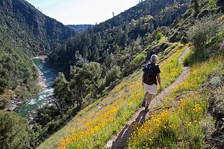
English: The Stevens Trail is a popular year-round hiking trail in the lower elevations of the Sierra Nevada mountain range. Historically, the trail connected the town of Iowa Hill with the city of Colfax, both in Placer County, California.
The current trail extends 4.5 miles along the northwestern slope of the North Fork of the American River Canyon. It begins at the trailhead in Colfax and ends at the confluence of Secret Ravine and the North Fork of the American River. |
|||
| തീയതി | Posted March 6, 2013 | |||
| സ്രോതസ്സ് | https://www.facebook.com/blmcalifornia/photos/a.381118831912797.90344.121009507923732/565469790144366/ | |||
| സ്രഷ്ടാവ് | CA BLM | |||
| അനുമതി (ഈ പ്രമാണത്തിന്റെ പുനരുപയോഗം) |
|
പ്രമാണ നാൾവഴി
ഏതെങ്കിലും തീയതി/സമയ കണ്ണിയിൽ ഞെക്കിയാൽ പ്രസ്തുതസമയത്ത് ഈ പ്രമാണം എങ്ങനെയായിരുന്നു എന്നു കാണാം.
| തീയതി/സമയം | ലഘുചിത്രം | അളവുകൾ | ഉപയോക്താവ് | അഭിപ്രായം | |
|---|---|---|---|---|---|
| നിലവിലുള്ളത് | 01:07, 30 ഓഗസ്റ്റ് 2016 | | 960 × 640 (200 കെ.ബി.) | Tillman | {{Information |Description ={{en|1=The Stevens Trail is a popular year-round hiking trail in the lower elevations of the Sierra Nevada mountain range. Historically, the trail connected the town of Iowa Hill with the city of Colfax, both in Placer Co... |
പ്രമാണത്തിന്റെ ഉപയോഗം
താഴെ കാണുന്ന താളിൽ ഈ ചിത്രം ഉപയോഗിക്കുന്നു:
പ്രമാണത്തിന്റെ ആഗോള ഉപയോഗം
താഴെ കൊടുത്തിരിക്കുന്ന മറ്റ് വിക്കികൾ ഈ പ്രമാണം ഉപയോഗിക്കുന്നു:
- azb.wikipedia.org സംരംഭത്തിലെ ഉപയോഗം
- en.wikipedia.org സംരംഭത്തിലെ ഉപയോഗം
- simple.wikipedia.org സംരംഭത്തിലെ ഉപയോഗം
- uk.wikipedia.org സംരംഭത്തിലെ ഉപയോഗം
- ur.wikipedia.org സംരംഭത്തിലെ ഉപയോഗം