പിറനീസ്-മോന്റ് പെർദു
പിറനീസ്-മോന്റ് പെർദു (സ്പാനിഷിൽ UNESCO Patrimonio Mundial Pirineos – Monte Perdido എന്നും അറിയപ്പെടുന്നു [2])) എന്നത് സ്പിയിനിനും ഫ്രാൻസിനും ഇടയിലെ അതിർത്തിയിലെ പിറനീസ് പർവ്വത ശൃംഖലയിൽ ഉള്ള ഒരു ലോക പൈതൃക സ്ഥലം ആണ്. Monte Perdido (ഫ്രെഞ്ച്: Mont Perdu) ഏറ്റവും ഉയർന്ന ഭാഗം അതിർത്തിയുടെ സ്പാനിഷ് ഭാഗത്താണ്. ഈ സ്ഥലം 1997ലാണ് നാമനിർദ്ദേശം ചെയ്യപ്പെടുന്നത്. 1999ൽ വിസ്തൃതമാക്കി ഫ്രാൻസിലെ Gèdre യിലെ കമ്മ്യൂണിനേയും ഉൾപ്പെടുത്തി.
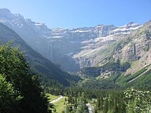
 The Cirque de Gavarnie in the French section of the World Heritage Site | |
| യുനെസ്കോ ലോക പൈതൃക സ്ഥാനം | |
|---|---|
| സ്ഥാനം | സ്പെയിൻ, ഫ്രാൻസ് |
| Area | 30,639 ഹെ (3.2980×10⁹ sq ft) |
| Includes | Ordesa y Monte Perdido National Park, Pyrénées National Park |
| മാനദണ്ഡം | iii, iv, v, vii, viii[1] |
| അവലംബം | 773 |
| നിർദ്ദേശാങ്കം | 42°39′N 0°03′E / 42.65°N 0.05°E |
| രേഖപ്പെടുത്തിയത് | 1997 (21st വിഭാഗം) |
| യുനെസ്കോ രേഖപ്പെടുത്തൽ ചരിത്രം | 1999 |
| Endangered | – |
അതിരിടുന്ന രണ്ട് ദേശീയ പാർക്കുകളെ ഈ സ്ഥലം ഉൾക്കൊള്ളുന്നു. സ്പെയിനിലെ Ordesa y Monte Perdido ദേശീയ പാർക്ക് മുഴുവനായും, ഫ്രാൻസിലെ Pyrénées Occidentales ദേശീയ പാർക്കിന്റെ കിഴക്കൻ ഭാഗവും. [3] ഈ ലോക പൈതൃകസ്ഥലത്തിൽ 30,639 ഹെക്റ്ററാണ് ഉൾക്കൊണ്ടിരിക്കുന്നത്. [2]
അവലംബം
തിരുത്തുക- ↑ http://whc.unesco.org/en/list/773.
{{cite web}}: Missing or empty|title=(help) - ↑ 2.0 2.1 "UNESCO Patrimonio Mundial Pirineos – Monte Perdido " mcu.es, retrieved 2013-08-20 (in Spanish)
- ↑ "Protected Areas and World Heritage". United Nations Environment Program - World Conservation Monitoring Centre. January 2000. Archived from the original on 2008-07-18. Retrieved 2008-08-12.
42°39′N 0°3′E / 42.650°N 0.050°E