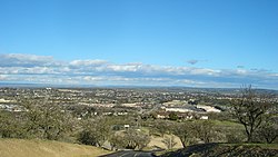
പാസോ റോബിൾസ്
പാസോ റോബിൾസ്, അമേരിക്കൻ ഐക്യനാടുകളിലെ സംസ്ഥാനമായ കാലിഫോർണിയയിൽ, സാൻ ലൂയിസ് ഒബിസ്പോ കൌണ്ടിയിൽ സ്ഥിതിചെയ്യുന്ന ഒരു നഗരമാണ്. കാലിഫോർണിയിയലെ സാൻ ലൂയിസ് ഒബിസ്പോ നഗരത്തിനു വടക്കായി സലിനാസ് നദിയോരത്തു സ്ഥിതിചെയ്യുന്ന ഈ നഗരം അതിലെ ചൂടു നീരുറവകൾ, വീഞ്ഞുത്പാദന കേന്ദ്രങ്ങളുടെ ആധിക്യം ഒലിവ് ഓയിൽ നിർമ്മാണം, ബദാം തോട്ടങ്ങൾ, കാലിഫോർണിയ മിഡ്-സ്റ്റേറ്റ് ഫെയറിന് ആതിഥ്യം വഹിക്കൽ എന്നിവയുടെ പേരിൽ പ്രസിദ്ധമാണ്.
പാസോ റോബിൾസ് നഗരം | ||
|---|---|---|
| City of El Paso de Robles | ||
 Overlooking Southern Paso Robles | ||
| ||
| Nickname(s): Paso | ||
 Location of El Paso de Robles (Paso Robles) in San Luis Obispo County, California. | ||
| Coordinates: 35°38′27″N 120°39′14″W / 35.64083°N 120.65389°W | ||
| Country | United States | |
| State | California | |
| County | San Luis Obispo | |
| Incorporated | March 11, 1889[1] | |
| • ഭരണസമിതി | Paso Robles City Council | |
| • City manager | Tom Frutchey[2] | |
| • City council | Mayor Steven W. Martin, John Hamon, Fred Strong, Steve Gregory, and Jim Reed[3] | |
| • Assemblymember | Jordan Cunningham (R)[4] | |
| • State senator | Bill Monning (D)[4] | |
| • ആകെ | 19.46 ച മൈ (50.39 ച.കി.മീ.) | |
| • ഭൂമി | 19.44 ച മൈ (50.36 ച.കി.മീ.) | |
| • ജലം | 0.01 ച മൈ (0.03 ച.കി.മീ.) 1.57% | |
| ഉയരം | 732 അടി (223 മീ) | |
| • ആകെ | 29,793 | |
| • കണക്ക് (2016)[8] | 31,907 | |
| • ജനസാന്ദ്രത | 1,640.97/ച മൈ (633.59/ച.കി.മീ.) | |
| സമയമേഖല | UTC−8 (Pacific) | |
| • Summer (DST) | UTC−7 (PDT) | |
| ZIP codes | 93446, 93447 | |
| Area code | 805 | |
| FIPS code | 06-22300 | |
| GNIS feature IDs | 254139, 2410415 | |
| വെബ്സൈറ്റ് | prcity | |
ഭൂമിശാസ്ത്രം
തിരുത്തുകപാസോ റോബിൾസ് നഗരം നിലനിൽക്കുന്ന അക്ഷാംശ രേഖാംശങ്ങൾ 35°37′36″N 120°41′24″W / 35.62667°N 120.69000°W ആണ്. ലോസ് ആഞ്ചലസ്, സാൻ ഫ്രാൻസിസ്കോ എന്നിവിടങ്ങളിലേയ്ക്ക് ഏകദേശം പകുതി ദൂരത്തിലാണിതു സ്ഥിതിചെയ്യുന്നത്. പാസ്സാ റോബിൾസിൽ ആണ് വടക്കൻ കാലിഫോർണിയ മേഖല അവസാനിക്കുന്നത്. പാസോ റോബിൾസ് ഭൂപ്രദേശം സമുദ്രനിരപ്പിൽനിന്ന് 675 മുതൽ 1,100 അടി വരെ (340 മീറ്റർ) ഉയരത്തിലാണ് സ്ഥിതിചെയ്യുന്നത്. എന്നാൽ പ്രധാന നഗരകേന്ദ്രത്തിന്റെ ഭൂരിഭാഗവും സമുദ്രനിരപ്പിൽ നിന്നും 740 അടി (230 മീറ്റർ) ഉയരത്തിലാണു നിലനിൽക്കുന്നത്. അമേരിക്കൻ ഐക്യനാടുകളിലെ സെൻസസ് ബ്യൂറോയുടെ കണക്കുകൾ പ്രകാരം പാസോ റോബിൾസ് നഗര പരിധി 19.4 ചതുരശ്ര മൈൽ ഭൂമി (50.3 ചതുരശ്ര കിലോമീറ്റർ) ഉൾക്കൊള്ളുന്നതാണ്. ഇതിൽ 98.43% പ്രദേശം കരഭൂമിയും 1.57% ജലം ഉൾക്കൊള്ളുന്നതുമാണ്.
അവലംബം
തിരുത്തുക- ↑ "California Cities by Incorporation Date". California Association of Local Agency Formation Commissions. Archived from the original (Word) on November 3, 2014. Retrieved August 25, 2014.
- ↑ "City of Paso Robles: City Manager Homepage". www.PRCity.com. Archived from the original on 2018-01-31. Retrieved November 4, 2017.
- ↑ "City Officials Listing" (PDF). City of El Paso de Robles. Archived from the original (PDF) on 2018-02-05. Retrieved January 9, 2015.
- ↑ 4.0 4.1 "Statewide Database". UC Regents. Retrieved November 18, 2014.
- ↑ "2016 U.S. Gazetteer Files". United States Census Bureau. Retrieved July 19, 2017.
- ↑ "Paso Robles". Geographic Names Information System. United States Geological Survey.
- ↑ "El Paso de Robles (Paso Robles) (city) QuickFacts". United States Census Bureau. Archived from the original on 2015-03-29. Retrieved February 25, 2015.
- ↑ ഉദ്ധരിച്ചതിൽ പിഴവ്: അസാധുവായ
<ref>ടാഗ്;USCensusEst2016എന്ന പേരിലെ അവലംബങ്ങൾക്ക് എഴുത്തൊന്നും നൽകിയിട്ടില്ല. - ↑ "City of Paso Robles: City Council Agendas". www.PRCity.com. Archived from the original on 2018-07-19. Retrieved November 4, 2017.
