ഒളിമ്പിയ, വാഷിങ്ടൺ
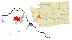
ഒളിമ്പിയ, യു.എസ്. സംസ്ഥാനമായ വാഷിംഗ്ടണിൻറെ തലസ്ഥാനവും തെഴ്സ്റ്റോൺ കൌണ്ടിയുടെ കൌണ്ടി സീറ്റുമാണ്. ഈ പ്രദേശം സംയോജിപ്പിച്ച് ഒരു കോർപ്പറേഷനായി രൂപം കൊണ്ടത് 1859 ജനുവരി 28 നായിരുന്നു. 2010 ലെ സെൻസസ് പ്രകാരം ഈ പട്ടണത്തിലെ ജനസംഖ്യ 46,478 ആണ്. പട്ടണത്തന്റെ അതിരുകൾ കിഴക്കു ഭാഗത്തായി ലാസേയും തെക്കു ഭാഗത്തായി തുംവാട്ടറുമാണ്. പ്യൂഗറ്റ് സൌണ്ട് മേഖലയിലെ ഒരു പ്രധാന സാസ്കാരിക സങ്കേതമാണിത്. സീറ്റിലിന് 60 മൈൽ (100 km) തെക്കുപടിഞ്ഞാറായി സ്ഥിതി ചെയ്യുന്ന ഒളിമ്പിയ വാഷിംഗ്ടൺ സംസ്ഥാനത്തെ ഏറ്റവും വലിയ പട്ടണമാണ്.
Olympia, Washington | |
|---|---|
| City of Olympia | |
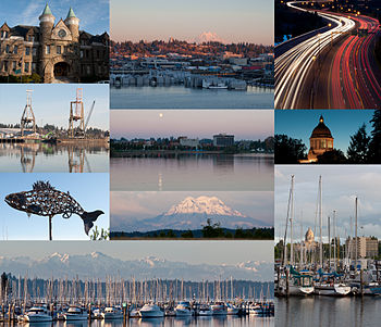
 (From top left to bottom right) Old Capitol Building, East Olympia, Interstate 5 at the junction of U.S. Route 101, Port of Olympia, Downtown from Capitol Lake, Washington State Capitol, Salmon sculpture, Mount Rainier, Olympic Mountains and Swantown Marina, Percival Landing Park. | |
| Nickname(s): Oly, O-Town | |
 | |
| Country | United States |
| State | Washington |
| County | Thurston |
| Incorporated | January 28, 1859 |
| • Mayor | Cheryl Selby |
| • City | 19.68 ച മൈ (50.97 ച.കി.മീ.) |
| • ഭൂമി | 17.82 ച മൈ (46.15 ച.കി.മീ.) |
| • ജലം | 1.86 ച മൈ (4.82 ച.കി.മീ.) |
| ഉയരം | 95 അടി (29 മീ) |
| • City | 46,478 |
| • കണക്ക് (2015)[4] | 50,302 |
| • റാങ്ക് | 1st in Thurston County 24th in Washington 750th in the United States |
| • ജനസാന്ദ്രത | 2,608.2/ച മൈ (1,007.0/ച.കി.മീ.) |
| • നഗരപ്രദേശം | 176,617 (US: 195th |
| • മെട്രോപ്രദേശം | 269,536 (US: 177th |
| Demonym(s) | Olympian |
| സമയമേഖല | Pacific |
| • Summer (DST) | Pacific |
| ZIP codes | 98500-98599 |
| ഏരിയ കോഡ് | 360 |
| FIPS code | 53-51300 |
| GNIS feature ID | 1533353[5] |
| വെബ്സൈറ്റ് | www |
അവലംബം
തിരുത്തുക- ↑ ഉദ്ധരിച്ചതിൽ പിഴവ്: അസാധുവായ
<ref>ടാഗ്;Gazetteer filesഎന്ന പേരിലെ അവലംബങ്ങൾക്ക് എഴുത്തൊന്നും നൽകിയിട്ടില്ല. - ↑ ഉദ്ധരിച്ചതിൽ പിഴവ്: അസാധുവായ
<ref>ടാഗ്;FactFinderഎന്ന പേരിലെ അവലംബങ്ങൾക്ക് എഴുത്തൊന്നും നൽകിയിട്ടില്ല. - ↑ "National 2010 urban area file containing a list of all urbanized areas and urban clusters (including Puerto Rico and the Island Areas) sorted by UACE code". United States Census Bureau, Geography Division. Archived from the original (TXT) on 2012-05-16. Retrieved November 21, 2012.
- ↑ "Population Estimates". United States Census Bureau. Retrieved June 15, 2016.
- ↑ "US Board on Geographic Names". United States Geological Survey. 2007-10-25. Retrieved 2008-01-31.