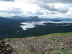
അലെക്നാഗിക്, അലാസ്ക
അലെക്നാഗിക് അമേരിക്കൻ ഐക്യനാടുകളിലെ അലാസ്കയിൽ അസംഘടിത ബറോയിലെ ദില്ലിംഗ്ഘാം സെൻസസ് ഏരിയായിൽപ്പെട്ട ഒരു രണ്ടാം ക്ലാസ് പട്ടണമാണ്. 2010 ലെ യു.എസ്. സെൻസസ്[4] പ്രകാരം 219 ആയിരുന്ന ഈ പട്ടണത്തിലെ ജനസംഖ്യ 2000 ൽ 221 ആയി വർദ്ധിച്ചിരുന്നു.
അലെക്നാഗിക് Alaqnaqiq | |
|---|---|
 Aleknagik lake, with the village of Aleknagik apparent in the lower left of the picture | |
| Coordinates: 59°16′42″N 158°37′23″W / 59.27833°N 158.62306°W | |
| Country | United States |
| State | Alaska |
| Census Area | Dillingham |
| Incorporated | March 26, 1973[1] |
| • Mayor | Carolyn Smith |
| • State senator | Lyman Hoffman (D-C)[2] |
| • State rep. | Bryce Edgmon (I) |
| • ആകെ | 43.52 ച മൈ (112.71 ച.കി.മീ.) |
| • ഭൂമി | 26.55 ച മൈ (68.76 ച.കി.മീ.) |
| • ജലം | 16.97 ച മൈ (43.95 ച.കി.മീ.) |
| ഉയരം | 36 അടി (11 മീ) |
| • ആകെ | 219 |
| • കണക്ക് (2018)[5] | 224 |
| • ജനസാന്ദ്രത | 8.44/ച മൈ (3.26/ച.കി.മീ.) |
| സമയമേഖല | UTC-9 (Alaska (AKST)) |
| • Summer (DST) | UTC-8 (AKDT) |
| ZIP code | 99555 |
| Area code | 907 |
| FIPS code | 02-01420 |
| GNIS feature ID | 1398091 |
| വെബ്സൈറ്റ് | www |
ഭൂമിശാസ്ത്രം
തിരുത്തുകഡില്ലിംഗ്ഹാമിൽ നിന്ന് 16 മൈൽ (26 കിലോമീറ്റർ) വടക്കുപടിഞ്ഞാറായി അലക്നാഗിക് തടാകത്തിന്റെ തെക്കുകിഴക്കേ അറ്റത്തുള്ള വുഡ് നദിയുടെ ഉറവിടത്തിലാണ് അലക്നാഗിക് പട്ടണം സ്ഥിതിചെയ്യുന്നത്. അലെക്നാഗിക് തടാകത്തിന്റെ പേരിലാണ് പട്ടണം അറിയപ്പെടുന്നത്.
അമേരിക്കൻ ഐക്യനാടുകളിലെ സെൻസസ് ബ്യൂറോയുടെ കണക്കുകൾപ്രകാരം പട്ടണത്തിന്റെ ആകെ വിസ്തീർണ്ണം 41.5 ചതുരശ്ര മൈൽ (107.5 ചതുരശ്ര കിലോമീറ്റർ ) ആണ്. അതിൽ 24.5 ചതുരശ്ര മൈൽ (63.5 ചതുരശ്ര കിലോമീറ്റർ) കരഭൂമിയും ബാക്കി 17.0 ചതുരശ്ര മൈൽ (44.0 ചതുരശ്ര കിലോമീറ്റർ ) അല്ലെങ്കിൽ 40.89 ശതമാനം ജലം ഉൾപ്പെട്ടതുമാണ്.[6]
കാലാവസ്ഥ
തിരുത്തുക| Aleknagik പ്രദേശത്തെ കാലാവസ്ഥ | |||||||||||||
|---|---|---|---|---|---|---|---|---|---|---|---|---|---|
| മാസം | ജനു | ഫെബ്രു | മാർ | ഏപ്രി | മേയ് | ജൂൺ | ജൂലൈ | ഓഗ | സെപ് | ഒക് | നവം | ഡിസം | വർഷം |
| റെക്കോർഡ് കൂടിയ °F (°C) | 49 (9) |
45 (7) |
52 (11) |
53 (12) |
71 (22) |
88 (31) |
88 (31) |
78 (26) |
70 (21) |
61 (16) |
47 (8) |
45 (7) |
88 (31) |
| ശരാശരി കൂടിയ °F (°C) | 20.6 (−6.3) |
27.9 (−2.3) |
27.5 (−2.5) |
37.0 (2.8) |
50.1 (10.1) |
61.2 (16.2) |
66.0 (18.9) |
63.0 (17.2) |
56.8 (13.8) |
41.2 (5.1) |
29.3 (−1.5) |
21.7 (−5.7) |
41.86 (5.48) |
| പ്രതിദിന മാധ്യം °F (°C) | 12.4 (−10.9) |
18.9 (−7.3) |
16.6 (−8.6) |
28.7 (−1.8) |
41.1 (5.1) |
50.9 (10.5) |
56.1 (13.4) |
53.1 (11.7) |
48.2 (9) |
33.5 (0.8) |
22.2 (−5.4) |
14.2 (−9.9) |
32.99 (0.55) |
| ശരാശരി താഴ്ന്ന °F (°C) | 4.1 (−15.5) |
9.8 (−12.3) |
5.7 (−14.6) |
20.3 (−6.5) |
32.0 (0) |
40.6 (4.8) |
46.1 (7.8) |
43.2 (6.2) |
39.5 (4.2) |
25.7 (−3.5) |
15.0 (−9.4) |
6.6 (−14.1) |
24.05 (−4.41) |
| താഴ്ന്ന റെക്കോർഡ് °F (°C) | −44 (−42) |
−35 (−37) |
−36 (−38) |
−15 (−26) |
11 (−12) |
23 (−5) |
31 (−1) |
28 (−2) |
22 (−6) |
−4 (−20) |
−20 (−29) |
−27 (−33) |
−44 (−42) |
| മഴ/മഞ്ഞ് inches (mm) | 1.84 (46.7) |
2.06 (52.3) |
2.41 (61.2) |
2.98 (75.7) |
3.12 (79.2) |
2.87 (72.9) |
2.77 (70.4) |
5.14 (130.6) |
4.81 (122.2) |
2.82 (71.6) |
2.55 (64.8) |
2.79 (70.9) |
36.16 (918.5) |
| മഞ്ഞുവീഴ്ച inches (cm) | 10.4 (26.4) |
14.9 (37.8) |
12.5 (31.8) |
7.8 (19.8) |
1.3 (3.3) |
0.0 (0) |
0.0 (0) |
0.0 (0) |
0.0 (0) |
2.3 (5.8) |
9.2 (23.4) |
8.4 (21.3) |
66.9 (169.9) |
| ഉറവിടം: [7] | |||||||||||||
അവലംബം
തിരുത്തുക- ↑ "Directory of Borough and City Officials 1974". Alaska Local Government. XIII (2). Juneau: Alaska Department of Community and Regional Affairs: 15. January 1974.
- ↑ "Senator Lyman Hoffman". Alaska Senate Majority. Alaskasenate.org. Archived from the original on 2020-04-08. Retrieved November 16, 2019.
- ↑ "2018 U.S. Gazetteer Files". United States Census Bureau. Retrieved Jul 1, 2019.
- ↑ 4.0 4.1 "Profile of General Population and Housing Characteristics: 2010 Demographic Profile Data". United States Census Bureau, American FactFinder. Archived from the original on 2020-02-12. Retrieved 2012-11-14. Archived 2020-02-12 at Archive.is ഉദ്ധരിച്ചതിൽ പിഴവ്: അസാധുവായ
<ref>ടാഗ്; "census2010" എന്ന പേര് വ്യത്യസ്തമായ ഉള്ളടക്കത്തോടെ നിരവധി തവണ നിർവ്വചിച്ചിരിക്കുന്നു - ↑ "Population and Housing Unit Estimates". Retrieved June 4, 2019.
- ↑ "Geographic Identifiers: 2010 Demographic Profile Data (G001): Aleknagik city, Alaska". U.S. Census Bureau, American Factfinder. Retrieved October 8, 2015.[പ്രവർത്തിക്കാത്ത കണ്ണി]
- ↑ "ALEKNAGIK, ALASKA - Climate Summary".
ബാഹ്യ ലിങ്കുകൾ
തിരുത്തുക- Aleknagik Archived 2018-06-30 at the Wayback Machine. at the Community Database Online from the Alaska Division of Community and Regional Affairs
- Maps from the Alaska Department of Labor and Workforce Development: 2000, 2010
