അതെർട്ടൺ
അതെർട്ടൺ, അമേരിക്കൻ ഐക്യനാടുകളിലെ കാലിഫോർണിയ സംസ്ഥാനത്തെ, സാൻ മറ്റിയോ കൗണ്ടിയിലുള്ള ഒരു സംയോജിത നഗരമാണ്. ഈ നഗരത്തിലെ ജനസംഖ്യ 2013 ലെ കണക്കുകൾ പ്രകാരം 7,159 ആയിരുന്നു. 2,500 നും 9,999 നും ഇടയിൽ ജനസംഖ്യയുള്ള യുഎസ് പട്ടണങ്ങളിൽ ഏറ്റവും കൂടുതൽ ആളോഹരി വരുമാനമുള്ള രാജ്യമായി ആതർട്ടൺ സ്ഥാനം നേടി. [10] ഇത് യുണൈറ്റഡ് സ്റ്റേറ്റ്സിലെ ഏറ്റവും ചെലവേറിയ ZIP കോഡായി റാങ്ക് ചെയ്യപ്പെടുന്നു.[11][12][13]
അതെർട്ടൺ, കാലിഫോർണിയ. | ||
|---|---|---|
Town | ||
| Town of Atherton | ||
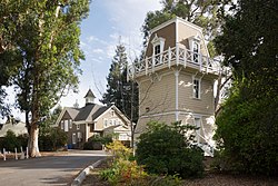
 ഹോൾബ്രൂക്ക്-പാമർ പാർക്ക് | ||
| ||
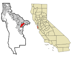
 Location in San Mateo County and the state of California | ||
| Coordinates: 37°27′31″N 122°12′0″W / 37.45861°N 122.20000°W[1] | ||
| Country | ||
| State | ||
| County | San Mateo | |
| Incorporated | September 12, 1923[2] | |
| നാമഹേതു | Faxon Dean Atherton[2] | |
| • City council[5] | Mayor Michael Lempres, Vice Mayor Cary Wiest, Elizabeth Lewis, Bill Widmer, and Rick DeGolia | |
| • Assemblymember | Marc Berman (D) (24th)[3] | |
| • State Senator | Jerry Hill (D) (13th)[3] | |
| • U. S. Rep. | Anna Eshoo (D) (18th)[4] | |
| • ആകെ | 5.049 ച മൈ (13.076 ച.കി.മീ.) | |
| • ഭൂമി | 5.017 ച മൈ (12.993 ച.കി.മീ.) | |
| • ജലം | 0.032 ച മൈ (0.082 ച.കി.മീ.) 0.63% | |
| ഉയരം | 59 അടി (18 മീ) | |
| • ആകെ | 6,914 | |
| • കണക്ക് (2013)[7] | 7,159 | |
| • ജനസാന്ദ്രത | 1,400/ച മൈ (530/ച.കി.മീ.) | |
| സമയമേഖല | UTC-8 (Pacific) | |
| • Summer (DST) | UTC-7 (PDT) | |
| ZIP code[8] | 94027 | |
| Area code[9] | 650 | |
| FIPS code | 06-03092 | |
| GNIS feature IDs | 1657960, 2411651 | |
| വെബ്സൈറ്റ് | www | |
ചരിത്രം
തിരുത്തുക1866-ൽ അതെർട്ടൺ, ഫെയർ ഓക്സ് എന്ന പേരിലായിരുന്നു അറിയപ്പെട്ടിരുന്നത്. മെൻലോ പാർക്കിൻറെ വടക്കുഭാഗത്തുള്ള വലിയ എസ്റ്റേറ്റുകളുടെ സൗകര്യാർത്ഥം, സാൻ ഫ്രാൻസിസ്കോക്കും സാൻ ജോസ്സിനും ഇടയിലുള്ള സതേൺ പസഫിക് റെയിൽവേയുടെ കാലിഫോർണിയ തീരദേശത്തെ ഫ്ലാഗ് സ്റ്റോപ്പായിരുന്നു അക്കാലത്ത് ഇത്. മുഴുവൻ പ്രദേശവും മെൻലോ പാർക്ക് എന്നായിരുന്നു അക്കാലത്ത് അറിയപ്പെട്ടിരുന്നത്. ഇപ്പോൾ സാൻ മറ്റിയോ കൌണ്ടിയിലുൾപ്പെട്ടിരിക്കുന്ന റാഞ്ചോ ഡി ലാസ് പൽഗാസിൻറെ ഭാഗമായിരുന്നു ഇതിൻറെ ഭൂരിഭാഗവും അന്ന്. 1874 ലും 1911 ലും ഉൾപ്പെടെ ഫെയർ ഓക്സ് സംയോജിപ്പിക്കാനുള്ള നിരവധി ശ്രമങ്ങൾ നടന്നിരുന്നു.
അവലംബം
തിരുത്തുക- ↑ 1.0 1.1 "Atherton". Geographic Names Information System. United States Geological Survey. Retrieved August 21, 2009.
- ↑ 2.0 2.1 "Atherton History". Town of Atherton. April 27, 2007. Archived from the original on 2018-12-24. Retrieved August 21, 2009.
- ↑ 3.0 3.1 "Statewide Database". UC Regents. Retrieved December 29, 2014.
- ↑ "California's 18-ആം Congressional District - Representatives & District Map". Civic Impulse, LLC. Retrieved March 13, 2013.
- ↑ "City Council". Town of Atherton. Retrieved December 29, 2014.
- ↑ "2010 Census Gazetteer Files – Places – California". United States Census Bureau. Retrieved March 26, 2015.
- ↑ 7.0 7.1 "Atherton (city) QuickFacts". United States Census Bureau. Archived from the original on 2012-08-16. Retrieved February 22, 2015.
- ↑ "USPS – ZIP Code Lookup – Search By City". United States Postal Service. Archived from the original on August 30, 2009. Retrieved August 21, 2009.
- ↑ "NANP Administration System". North American Numbering Plan Administration. Archived from the original on 2018-12-24. Retrieved August 21, 2009.
- ↑ "Population (1988) and Per Capita Income (1987) Estimates [United States]: Governmental Units". ICPSR Data Holdings. 1990-10-16. Retrieved 2019-07-02.
- ↑ Levy, Francesca (27 September 2010). "America's Most Expensive ZIP Codes". Forbes.
- ↑ Brennan, Morgan (16 October 2013). "America's Most Expensive Zip Codes In 2013: The Complete List". Forbes. Archived from the original on 2017-08-25. Retrieved 2019-07-02.
- ↑ Sharf, Samantha (8 December 2016). "Full List: America's Most Expensive ZIP Codes 2016". Forbes. Retrieved 24 August 2017.

