യങ്സ്ടൗൺ
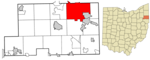
യങ്സ്ടൗൺ യു.എസ്. സംസ്ഥാനമായ ഒഹായോയിലെ ഒരു നഗരവും മഹോണിംഗ് കൗണ്ടിയിലെ ഏറ്റവും വലിയ നഗരവും അതിൻറെ കൗണ്ടി സീറ്റുമാണ്. 2020 ലെ യു.എസ്. സെൻസസ് പ്രകാരം, യങ്സ്ടൗണിൽ 60,068 ജനസംഖ്യയുണ്ട്.[3] 541,243 ജനസംഖ്യയുള്ള യങ്സ്റ്റൗൺ-വാറൻ-ബോർഡ്മാൻ, OH-PA മെട്രോപൊളിറ്റൻ സ്റ്റാറ്റിസ്റ്റിക്കൽ പ്രദേശം, അമേരിക്കൻ ഐക്യനാടുകളിലെ 107-ാമത്തെ വലിയ മെട്രോപൊളിറ്റൻ പ്രദേശമാണ്.[6] ക്ലീവ്ലാൻഡിന് ഏകദേശം 58 മൈൽ (93 കി.മീ) തെക്കുകിഴക്കായും പെൻസിൽവാനിയയിലെ പിറ്റ്സ്ബർഗിൽ നിന്ന് 61 മൈൽ (100 കി.മീ) വടക്കുപടിഞ്ഞാറായും മഹോണിംഗ് നദിയോരത്താണ് യങ്സ്ടൗൺ സ്ഥിതി ചെയ്യുന്നത്. സ്വന്തമായി മീഡിയ മാർക്കറ്റ് ഉള്ളതിനു പുറമേ, വടക്കുകിഴക്കൻ ഒഹായോയുടെയും ഗ്രേറ്റർ പിറ്റ്സ്ബർഗ് മേഖലയുടെയും സാമീപ്യത്താൽ യംഗ്സ്ടൗൺ പലപ്പോഴും ഈ പ്രദേശങ്ങളുടെ ഭാഗമായി വർഗ്ഗീകരിക്കപ്പെടുന്നു. ഇന്റർസ്റ്റേറ്റ് 80 വഴി ഷിക്കാഗോയ്ക്കും ന്യൂയോർക്ക് നഗരത്തിനും മധ്യേയാണ് യങ്സ്ടൗണിൻറെ സ്ഥാനം.
യങ്സ്ടൗൺ, ഒഹായോ | |||||||||
|---|---|---|---|---|---|---|---|---|---|
| City of Youngstown | |||||||||
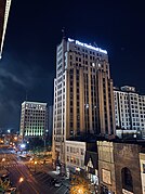
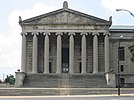
From top: Downtown Youngstown from Wean Park, downtown Youngstown at night, West Federal Street, Lanterman's Mill, Jones Hall at Youngstown State University, a home in Wick Park Historic District, and Stambaugh Auditorium | |||||||||
| |||||||||
| Nickname(s): The City of You; The YO; Steel Town; Little Chicago; Yompton | |||||||||
 | |||||||||
| Coordinates: 41°6′N 80°39′W / 41.100°N 80.650°W | |||||||||
| Country | |||||||||
| State | |||||||||
| County | Mahoning, Trumbull | ||||||||
| Founded | 1796 | ||||||||
| Incorporated | 1848 (Village) | ||||||||
| 1867 (City) | |||||||||
| സ്ഥാപകൻ | John Young | ||||||||
| • ഭരണസമിതി | Council of the City of Youngstown | ||||||||
| • Mayor | Jamael Tito Brown (D) [1] | ||||||||
| • City | 34.56 ച മൈ (89.52 ച.കി.മീ.) | ||||||||
| • ഭൂമി | 33.93 ച മൈ (87.87 ച.കി.മീ.) | ||||||||
| • ജലം | 0.64 ച മൈ (1.64 ച.കി.മീ.) | ||||||||
| • City | 60,068 | ||||||||
| • ജനസാന്ദ്രത | 1,738.08/ച മൈ (671.00/ച.കി.മീ.) | ||||||||
| • നഗരപ്രദേശം | 387,550 (US: 97th) | ||||||||
| • മെട്രോപ്രദേശം | 541,926 (US: 103rd) | ||||||||
| • CSA | 645,003 (US: 74th) | ||||||||
| സമയമേഖല | UTC−5 (Eastern Standard Time) | ||||||||
| • Summer (DST) | UTC−4 (Eastern Daylight Time) | ||||||||
| ZIP Code | 15 Total ZIP Codes:
| ||||||||
| Area Code | 330, 234 | ||||||||
| FIPS code | 39-88000 | ||||||||
| GNIS feature ID | 1058156[5] | ||||||||
| Expressway | |||||||||
| U.S. Route | |||||||||
| വെബ്സൈറ്റ് | youngstownohio.gov | ||||||||
സമൂഹത്തിലെ ആദ്യത്തെ തടിമില്ലും ധാന്യമില്ലും സ്ഥാപിച്ച ന്യൂയോർക്കിലെ വൈറ്റ്സ്റ്റൗണിൽ നിന്നുള്ള ആദ്യകാല കുടിയേറ്റക്കാരനായ ജോൺ യങ്ങിന്റെ പേരിലാണ് നഗരം അറിയപ്പെടുന്നത്.
ഭൂമിശാസ്ത്രം
തിരുത്തുകഅമേരിക്കൻ ഐക്യനാടുകളിലെ സെൻസസ് ബ്യൂറോയുടെ കണക്കുകൾ പ്രകാരം 34.60 ചതുരശ്ര മൈൽ (89.61 ചതുരശ്ര കിലോമീറ്റർ) വിസ്തീർണ്ണമുള്ള ഈ, നഗരത്തിൻറെ 33.96 ചതുരശ്ര മൈൽ (87.96 ചതുരശ്ര കിലോമീറ്റർ) കരപ്രദേശവും ബാക്കി 0.64 ചതുരശ്ര മൈൽ (1.66 km2) പ്രദേശം ജലം ഉൾപ്പെട്ടതുമാണ്
അവലംബം
തിരുത്തുക- ↑ "City of Youngstown, Ohio".
- ↑ "2019 U.S. Gazetteer Files". United States Census Bureau. Retrieved July 28, 2020.
- ↑ 3.0 3.1 "QuickFacts: Youngstown city, Ohio". census.gov. Retrieved 2021-09-13.
- ↑ "U.S. Census website". United States Census Bureau. Retrieved March 20, 2010.
- ↑ "US Board on Geographic Names". United States Geological Survey. October 25, 2007. Retrieved January 31, 2008.
- ↑ "Ohio Metropolitan & Micropolitan Statistical Areas". Ohio Hometown Locator. Retrieved September 4, 2019.


