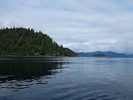
ഹൈഡ ഗ്വായ്
ഹൈഡ ഗ്വായ് (/ˈhaɪdə ˈɡwaɪ/;[2] Haida: X̱aaydag̱a Gwaay.yaay /X̱aayda gwaay അക്ഷരാർത്ഥത്തിൽ "ഹൈഡ ജനതയുടെ ദ്വീപുകൾ")[3] കാനഡയുടെ വടക്കൻ പസഫിക് തീരത്ത് നിന്ന് ഏകദേശം 45–60 കിലോമീറ്റർ (30–40 മൈൽ) അകലെയുള്ള ഒരു ദ്വീപസമൂഹമാണ്. ദ്വീപുകളെ പ്രധാന കരയിൽനിന്ന് കിഴക്ക് ആഴം കുറഞ്ഞ ഹെകേറ്റ് കടലിടുക്ക് വേർതിരിക്കുന്നു.[4] ക്യൂൻ ഷാർലറ്റ് സൗണ്ട് തെക്ക്, വാൻകൂവർ ദ്വീപിന് അപ്പുറത്തായി സ്ഥിതിചെയ്യുന്നു. വടക്കുഭാഗത്ത് തർക്കത്തിലുള്ള ഡിക്സൺ എൻട്രൻസ് യുഎസ് സംസ്ഥാനമായ അലാസ്കയിലെ അലക്സാണ്ടർ ദ്വീപസമൂഹത്തിൽ നിന്ന് ഹൈഡ ഗ്വായിയെ വേർതിരിക്കുന്നു.
| Nickname: "Queen Charlottes" "The Charlottes" | |
|---|---|
 | |
 Map of Haida Gwaii | |
| Geography | |
| Location | Pacific Ocean |
| Coordinates | z53°N 132°W / 53°N 132°W |
| Total islands | c. 150 |
| Major islands | Graham Island, Moresby Island |
| Area | 10,180 കി.m2 (3,930 ച മൈ) |
| Highest elevation | 1,164 m (3,819 ft) |
| Highest point | Mount Moresby |
| Province | British Columbia |
| Largest settlement | Village of Queen Charlotte (pop. 948) |
| Demographics | |
| Population | 4,761 [1] (2008) |
| Pop. density | 0.468 /km2 (1.212 /sq mi) |
| Additional information | |
| Time zone | |
വടക്ക് ഗ്രഹാം ദ്വീപ് (കീസ് ഗ്വായ്), തെക്ക് മോറെസ്ബി ദ്വീപ് (T'aawxii X̱aaydaɢ̠a Gwaay.yaay linaɢ̠waay, അക്ഷരാർത്ഥത്തിൽ: പകുതി ദ്വീപിലെ തെക്കൻ ആളുകൾ, അല്ലെങ്കിൽ ഗ്വായ് ഹാനാസ് "സൗന്ദര്യത്തിന്റെ ദ്വീപുകൾ") എന്നിങ്ങനെ രണ്ട് പ്രധാന ദ്വീപുകൾ ഉൾക്കൊള്ളുന്ന ഹൈഡാ ഗ്വായ്ക്ക് ഉടനീളമായി മൊത്തം 10,180 ചതുരശ്ര കിലോമീറ്റർ (3,931 ചതുരശ്ര മൈൽ) ഭൂവിസ്തൃതിയിൽ ഏകദേശം 400 ചെറിയ ദ്വീപുകളും[5] സ്ഥിതിചെയ്യുന്നു. ആന്തണി ദ്വീപ് (Ḵ'waagaaw / Sɢ̠ang Gwaay), ബർണാബി ദ്വീപ് (Sɢ̠aay Kun Gwaay.yaay), ആൽഡർ ദ്വീപ് (Ḵ'uuna Gwaay / Ḵ'uuna Gwaay.yaay),[6] കുൻഖിത് ദ്വീപ് എന്നിവ മറ്റു പ്രധാന ദ്വീപുകളിൽ ഉൾപ്പെടുന്നു.
കനേഡിയൻ പ്രവിശ്യയായ ബ്രിട്ടീഷ് കൊളംബിയയുടെ ഭാഗമായ ഈ ദ്വീപുകൾ മുമ്പ് ക്വീൻ ഷാർലറ്റ് ദ്വീപുകൾ എന്നും ഗ്രാമ്യ ഭാഷയിൽ "ചാർലോട്ട്സ്" എന്നും അറിയപ്പെട്ടിരുന്നു.[7] ബ്രിട്ടീഷ് കൊളംബിയയും ഹൈഡ ജനങ്ങളും തമ്മിലുള്ള കുൻസ്റ്റാ ഗു - കുൻസ്റ്റായാഹ് ഒത്തുതീർപ്പ് രേഖയുടെ[8] ഭാഗമായി 2010 ജൂൺ 3 ന് ഹൈഡ ഗ്വായ് അനുരഞ്ജന നിയമം ഔപചാരികമായി ഈ ദ്വീപസമൂഹത്തിന്റെ പേരുമാറ്റം നടത്തി.[9][10][11]
ഈ ദ്വീപുകൾ ഹൈഡ രാഷ്ട്രത്തിന്റെ ഹൃദയഭാഗമായി രൂപപ്പെട്ടിരിക്കുന്നു. ഏകദേശം 13,000 വർഷങ്ങളായി[12] ഈ ദ്വീപുകളിൽ അധിവസിക്കുന്ന ഹൈഡ ജനങ്ങൾ നിലവിൽ ജനസംഖ്യയുടെ പകുതിയോളം വരും.[13]
അവലംബം
തിരുത്തുക- ↑ "Population Estimates". bcstats.gov.be.ca. Archived from the original on 22 July 2012. Retrieved 28 October 2010.
- ↑ "Haida Gwaii". BC Geographical Names.
- ↑ "Ship X̱aayda Kil Glossary" (PDF). sd50.bc.ca. Skidegate Haida Immersion Program. March 2011. Archived from the original (PDF) on 2012-06-10. Retrieved 19 February 2018.
- ↑ "Welcome to Haida Gwaii: "Haida Gwaii is not only where we are, this is who we are"". Haida Gwaii Observer. 2018. p. 3.[better source needed]
- ↑ "Welcome to Haida Gwaii: "Haida Gwaii is not only where we are, this is who we are"". Haida Gwaii Observer. 2018. p. 3.[better source needed]
- ↑ "Ship X̱aayda Kil Glossary" (PDF). sd50.bc.ca. Skidegate Haida Immersion Program. March 2011. Archived from the original (PDF) on 2012-06-10. Retrieved 19 February 2018.
- ↑ "Queen Charlotte Islands". BC Geographical Names.
- ↑ Haida Nation; Her Majesty the Queen in Her Right of the Province of British Columbia (Autumn 2015). "Amending Agreement of the Kunst'aa guu - Kunst'aayah Reconciliation Protocol" (PDF). Retrieved 19 February 2018.
- ↑ "Haida Gwaii". BC Geographical Names.
- ↑ Legislative Assembly of British Columbia. "Bill 18 — 2010: Haida Gwaii Reconciliation Act". Queen's Printer. Archived from the original on 2012-04-03. Retrieved 17 March 2011.
- ↑ "HAIDA GWAII RECONCILIATION ACT".
- ↑ "History: Where we've come from (our history)". Masset BC. Village of Masset. Retrieved 19 February 2018.
Haida Gwaii has been home to the Haida since time immemorial, and evidence of their habitation of the islands dates back 13,000 years.
- ↑ History of the Haida Nation Archived 2016-05-14 at the Wayback Machine., Council of the Haida Nation, retrieved 2014-08-16: "Today, Haida people make up half of the 5000 people living on the islands."