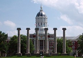
കൊളംബിയ, മിസോറി
കൊളംബിയ /kəˈlʌmbiə/ അമേരിക്കൻ ഐക്യനാടുകളിലെ മിസോറി സംസ്ഥാനത്തെ ഒരു നഗരമാണ്. ബൂൺ കൗണ്ടിയുടെ കൗണ്ടി സീറ്റായ ഇത് മിസോറി സർവകലാശാലയുടെ ആസ്ഥാനവുമാണ്.[9] 1821-ൽ സ്ഥാപിതമായ ഇത് ഫൈവ് കൗണ്ടി കൊളംബിയ മെട്രോപൊളിറ്റൻ പ്രദേശത്തെ ഒരു പ്രധാന നഗരമാണ്. 2022- ലെ കണക്കുകൾ പ്രകാരം 128,555 താമസക്കാരുള്ള ഈ നഗരം മിസോറിയിലെ ഏറ്റവും ജനസംഖ്യയുള്ളതും അതിവേഗം വളരുന്നതുമായ നാലാമത്തെ നഗരമാണ്.[10][11][12]
കൊളംബിയ, മിസോറി | |||
|---|---|---|---|
From top, left to right: Jesse Hall and The Columns at the University of Missouri, Missouri United Methodist Church, the State Historical Society of Missouri, The Big Tree, Memorial Union, Ragtag Cinema, the Boone County Courthouse | |||
| |||
| Nicknames: | |||
 Interactive map of Columbia | |||
| Coordinates: 38°56′51″N 92°19′36″W / 38.94750°N 92.32667°W | |||
| Country | |||
| State | |||
| County | Boone | ||
| Founded | 1821 | ||
| Incorporated | 1826 | ||
| നാമഹേതു | Columbia (personification) | ||
| • ഭരണസമിതി | Columbia City Council | ||
| • Mayor | Barbara Buffaloe[3] | ||
| • City manager | De'Carlon Seewood | ||
| • ആകെ | 67.45 ച മൈ (174.70 ച.കി.മീ.) | ||
| • ഭൂമി | 67.17 ച മൈ (173.98 ച.കി.മീ.) | ||
| • ജലം | 0.28 ച മൈ (0.72 ച.കി.മീ.) | ||
| ഉയരം | 761 അടി (232 മീ) | ||
(2020) | |||
| • ആകെ | 126,254 | ||
| • കണക്ക് (2022) | 128,555 | ||
| • റാങ്ക് | US: 219th MO: 4th | ||
| • ജനസാന്ദ്രത | 1,879.48/ച മൈ (725.67/ച.കി.മീ.) | ||
| • MSA (2019) | 208,173 (216th) | ||
| • CSA (2019) | 258,309[6] (119th) | ||
| Demonym(s) | Columbian(s) | ||
| സമയമേഖല | UTC−6 (CST) | ||
| • Summer (DST) | UTC−5 (CDT) | ||
| ZIP Codes | 65201, 65202, 65203, 65211 | ||
| ഏരിയ കോഡ് | 573 | ||
| FIPS code | 29-15670 | ||
| GNIS feature ID | 2393605[5] | ||
| U.S. Routes | |||
| Interstates | |||
| വെബ്സൈറ്റ് | www | ||
| [7][8] | |||
ചരിത്രം
തിരുത്തുക1800-കളുടെ പ്രാരംഭത്തിൽ അക്കാലത്ത് ബൂൺസ്ലിക്ക് എന്നറിയപ്പെട്ടിരുന്ന ഒരു പ്രദേശത്ത് കെന്റക്കിയിൽ നിന്നും അതുപോലെതന്നെ വിർജീനിയയിൽ നിന്നുമുള്ള അമേരിക്കൻ പയനിയർമാരുടെ കുടിയേറ്റത്തോടെയാണ് കൊളംബിയ നഗരത്തിൻറെ ഉത്ഭവം ആരംഭിക്കുന്നത്. 1815-ന് മുമ്പുള്ള കാലത്ത്, 1812-ലെ യുദ്ധസമയത്തെ തദ്ദേശീയ അമേരിന്ത്യൻ ആക്രമണ ഭീഷണിയെത്തുടർന്ന് ഈ പ്രദേശത്തെ വാസസ്ഥലം ചെറിയ മരക്കോട്ടകളിൽ പരിമിതപ്പെടുത്തിയിരുന്നു. യുദ്ധാവസാനത്തോടെ കാൽനടയായും കുതിരപ്പുറത്തും വണ്ടികളിലും വന്നിരുന്ന കുടിയേറ്റക്കാർ, പലപ്പോഴും മുഴുവൻ കുടുംബങ്ങളുമായും ചിലപ്പോൾ അടിമകളായ ആഫ്രിക്കൻ അമേരിക്കക്കാരുമായും ബൂൺസ് ലിക്ക് റോഡിലൂടെ എത്തി. 1818 ആയപ്പോഴേക്കും ഈ പ്രദേശത്തെ വർദ്ധിച്ചുവരുന്ന ജനസംഖ്യ ഹോവാർഡ് കൗണ്ടിയിൽ നിന്ന് ഒരു പുതിയ കൗണ്ടി സൃഷ്ടിക്കേണ്ടത് ആവശ്യമാണെന്ന് തിരിച്ചറിഞ്ഞു. പടിഞ്ഞാറ് മോണിറ്റോ ക്രീക്കും കിഴക്ക് സെഡാർ ക്രീക്കും ഇതിൻറെ വ്യക്തമായ പ്രകൃതിദത്ത അതിരുകളായിരുന്നു.
അവലംബം
തിരുത്തുക- ↑ Switzler, William (1882). History of Boone County, Missouri. St. Louis Western Historical Company. pp. 220–221.
- ↑ Alban, Sarah (30 October 2007). "How CoMO does Halloween". The Maneater. Archived from the original on October 16, 2008. Retrieved July 18, 2008.
- ↑ "City Council".
- ↑ "ArcGIS REST Services Directory". United States Census Bureau. Retrieved August 28, 2022.
- ↑ 5.0 5.1 U.S. Geological Survey Geographic Names Information System: കൊളംബിയ, മിസോറി
- ↑ "Annual Estimates of the Resident Population: April 1, 2010 to July 1, 2017 – Combined Statistical Area; and for Puerto Rico – 2017 Population Estimates". U.S. Census Bureau. Retrieved April 27, 2018.[പ്രവർത്തിക്കാത്ത കണ്ണി]
- ↑ "About Columbia". City of Columbia, Missouri. Archived from the original on ഡിസംബർ 25, 2007. Retrieved ജനുവരി 1, 2008.
- ↑ "City of Columbia, Missouri Demographic Statistics" (PDF). City of Columbia, Missouri. Archived from the original (PDF) on December 1, 2007. Retrieved January 1, 2008.
- ↑ "Find a County". National Association of Counties. Archived from the original on May 31, 2011. Retrieved 2011-06-07.
- ↑ Sauter, Michael B. (10 April 2018). "Is your city's population keeping pace? The fastest-growing city in each state". USA Today.
- ↑ "U.S. Census Bureau QuickFacts: Columbia city, Missouri". www.census.gov.
- ↑ "2020 Census estimates for Missouri cities". Retrieved May 29, 2021.


