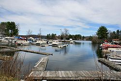
ചാര്ഗോഗഗോഗ്മാഞ്ചൗഗഗോഗ്ചൗബുനഗുംഗമൗഗ് തടാകം
(Chargoggagoggmanchauggagoggchaubunagungamaugg തടാകം എന്ന താളിൽ നിന്നും തിരിച്ചുവിട്ടതു പ്രകാരം)
ഈ ലേഖനത്തിന്റെ തലക്കെട്ടും ഉള്ളടക്കവും മലയാളത്തിലേക്ക് വിവർത്തനം ചെയ്യേണ്ടതാണ്. താങ്കൾക്ക് വിവർത്തനം ചെയ്യാമെന്നുറപ്പുണ്ടെങ്കിൽ, സധൈര്യം ഈ താൾ തിരുത്തി വിവർത്തനം ചെയ്യാവുന്നതാണ്. |
മസാച്ചുസെറ്റ്സിലെ കണക്ടിക്കട്ട് അതിർത്തിയിലുള്ള 1442 ഏക്കർ വിസ്താരമുള്ള ഒരു തടാകമാണ് Webster Lake എന്നും അറിയപ്പെടുന്ന Lake Chaubunagungamaug, 1921 മുതൽ ഇതിന്റെ പേര് Lake Chargoggagoggmanchauggagoggchaubunagungamaugg എന്നാണ്.
| Lake Chaubunagungamaug | |
|---|---|
| Lake Chargoggagoggmanchauggagoggchaubunagungamaugg | |
 | |
| സ്ഥാനം | Webster, Massachusetts |
| നിർദ്ദേശാങ്കങ്ങൾ | 42°02′30″N 71°50′30″W / 42.04167°N 71.84167°W |
| Basin countries | United States |
| പരമാവധി നീളം | 3.25 മൈ (5.23 കി.മീ) |
| പരമാവധി വീതി | 1.125 മൈ (1.811 കി.മീ) |
| ഉപരിതല വിസ്തീർണ്ണം | 1,442 ഏക്കർ (584 ഹെ) |
| തീരത്തിന്റെ നീളം1 | 17 മൈ (27 കി.മീ) |
| ഉപരിതല ഉയരം | 477 അടി (145 മീ) |
| Islands | 8 |
| 1 Shore length is not a well-defined measure. | |
പേര്
തിരുത്തുക1921 - മുതലുള്ള നീണ്ട പേര്
തിരുത്തുകതടാകത്തിന്റെ അർത്ഥത്തിന്റെ തമാശരൂപത്തിലുള്ള വിവർത്തനം ഇങ്ങനെയാണ് : "നീ നിന്റെ വശത്ത് മീൻപിടിച്ചോളുക, ഞാൻ എന്റെ വശത്ത് മീൻപിടിച്ചോളും, മധ്യഭാഗത്ത് ഒരുത്തനും പിടിക്കരുത്".[1][2]
ഭൂമിശാസ്ത്രം
തിരുത്തുകദ്വീപുകൾ
തിരുത്തുകWebster Lake has about 7–8 islands. Some have houses and are habitable; a few are extremely small and uninhabitable. They include:
- Long Island: The largest island in Webster Lake. It has many homes and has electric power lines, underground/underwater municipal water and sewer service, and several fire hydrants. It is in the Middle Pond.
- Goat Island: The second largest island. It has a few homes and boats. It is in the Middle Pond but isolated from the cluster of islands that include Long Island.
- Well Island: A smaller island with one house west of Long Island in the Middle Pond.
- Strip Island: Generally northeast of Long Island and north of Cobble Island with one house, also in the Middle Pond.
- Cobble Island: East of Long Island, in the Middle Pond.
- Little Island: In South Pond, right out of the no wake zone from the Middle Pond, one house.
- Birch Island: Large island on west edge of Middle Pond with Pout Pond on west side and swamp surrounding entire island. It is located roughly between Treasure Island and The Narrows with access by a bridge on Birch Island Road near The Narrows. There are many homes on island and establishment once called Birch Island Pavilion, now called Waterfront Mary's.
- Small island near east side of Narrows in Middle Pond. May be called Misery Island, but not sure of that name.
Marinas
തിരുത്തുകWebster lake has two marinas:
- Lakeview Marine: The only full-service marine store and service shop on Webster Lake.
- Point Breeze: A restaurant with a small marina. Point Breeze Marina has the only dockside gas pump on the lake.
ജനകീയസാഹിത്യത്തിൽ
തിരുത്തുകഅവലംബം
തിരുത്തുക- ↑ Patenaude, Ed (June 28, 2001). "Fabrication leaves us gasping - Old twist to name of lake comes to light". Worcester Telegram & Gazette. Archived from the original on July 23, 2003. Retrieved May 31, 2011.
- ↑ Knapton, Sarah (April 22, 2009). "Longest Place Name in US Spelt Wrongly". The Telegraph. London. Retrieved March 28, 2012.
പുറത്തേക്കുള്ള കണ്ണികൾ
തിരുത്തുകLake Chaubunagungamaug എന്ന വിഷയവുമായി ബന്ധപ്പെട്ട ചിത്രങ്ങൾ വിക്കിമീഡിയ കോമൺസിലുണ്ട്.
- A history of the lake Archived 2011-05-14 at the Wayback Machine.
- NY Times - What's the Name of That Lake? It's Hard to Say
- Listen to the Lake Song
- Webster Lake Real Estate Boat Tours Archived 2011-09-23 at the Wayback Machine.
- Map of Lake Chaubunagungamaugg
- Map of the area watershed
- Lake Chaubunagungamaugg photos 1 Archived 2009-02-27 at the Wayback Machine.
- Lake Chaubunagungamaugg photos 2