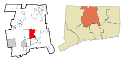
ഹാർട്ട്ഫോർഡ്, കണക്ടിക്കട്ട്
ഹാർട്ട്ഫാർഡ് പട്ടണംis യു.എസ്. സംസ്ഥാനമായ കണക്റ്റിക്കട്ടിൻറെ തലസ്ഥാനമാണ്. 2010 ലെ സെൻസസ് അനുസരിച്ച് ഹാർട്ട്ഫാർഡ് പട്ടണത്തിലെ ജനസംഖ്യ 124,775[7] ആണ്. ബ്രിഡ്ജ് പോർട്ട്, ന്യൂ ഹാവൻ എന്നീ പട്ടണങ്ങൾ കഴിഞ്ഞാൽ കണക്റ്റിക്കട്ട് സംസ്ഥാനത്തെ മൂന്നാമത്തെ വലിയ പട്ടണമാണ് ഹാർട്ട്ഫാർഡ്.
ഹാർട്ട്ഫോർഡ്, കണക്ടിക്കട്ട് | ||||||||
|---|---|---|---|---|---|---|---|---|
State capital of Connecticut | ||||||||
| City of Hartford | ||||||||
| ||||||||
| ||||||||
Nickname(s):
| ||||||||
| Motto(s): Post Nubila Phoebus (Latin) "After the clouds, the sun"[1] | ||||||||
 Location within Hartford County and Connecticut | ||||||||
| Coordinates: 41°45′45″N 72°40′27″W / 41.76250°N 72.67417°W | ||||||||
| Country | United States | |||||||
| State | ||||||||
| Region | New England | |||||||
| County | Hartford | |||||||
| Settled | October 15, 1635 | |||||||
| Named | February 21, 1637[2] | |||||||
| Incorporated (city) | May 29, 1784[3] | |||||||
| Consolidated | April 1, 1896[4] | |||||||
| നാമഹേതു | Hertford, Hertfordshire | |||||||
| • Mayor | Luke Bronin (D) | |||||||
| • Council | Hartford City Council | |||||||
| • State capital of Connecticut | 18.05 ച മൈ (46.76 ച.കി.മീ.) | |||||||
| • ഭൂമി | 17.38 ച മൈ (45.01 ച.കി.മീ.) | |||||||
| • ജലം | 0.68 ച മൈ (1.75 ച.കി.മീ.) | |||||||
| • നഗരം | 469 ച മൈ (1,216 ച.കി.മീ.) | |||||||
| ഉയരം | 59 അടി (18 മീ) | |||||||
| ജനസംഖ്യ (2010) | 124,775 | |||||||
| • കണക്ക് (2019)[6] | 1,22,105 | |||||||
| • ജനസാന്ദ്രത | 7,026.01/ച മൈ (2,712.68/ച.കി.മീ.) | |||||||
| • നഗരപ്രദേശം | 9,24,859 (US: 47th) | |||||||
| • മെട്രോപ്രദേശം | 12,14,295 (US: 47th) | |||||||
| • CSA | 14,89,361 (US: 36th) | |||||||
| Demonym(s) | Hartfordite | |||||||
| സമയമേഖല | UTC−05:00 (EST) | |||||||
| • Summer (DST) | UTC−04:00 (EDT) | |||||||
| ZIP Codes | 061xx | |||||||
| ഏരിയ കോഡ് | 860/959 | |||||||
| FIPS code | 09-37000 | |||||||
| GNIS feature ID | 213160 | |||||||
| Primary Airport | Bradley International Airport | |||||||
| Secondary Airport | Hartford–Brainard Airport | |||||||
| Interstates | ||||||||
| U.S. Highways | ||||||||
| State Routes | ||||||||
| Commuter Rail | ||||||||
| Rapid Transit | ||||||||
| വെബ്സൈറ്റ് | www | |||||||
1635-ൽ സ്ഥാപിതമായ ഹാർട്ട്ഫോർഡ് അമേരിക്കൻ ഐക്യനാടുകളിലെ ഏറ്റവും പഴയ നഗരങ്ങളിലൊന്നാണ്. രാജ്യത്തെ ഏറ്റവും പഴയ പബ്ലിക് ആർട്ട് മ്യൂസിയം (വാഡ്സ്വർത്ത് അഥീനിയം), പൊതുധനസഹായം ലഭിച്ച ഏറ്റവും പഴയ ഉദ്യാനം (ബുഷ്നെൽ പാർക്ക്), തുടർച്ചയായി പ്രസിദ്ധീകരിക്കുന്ന ഏറ്റവും പഴയ പത്രം (ഹാർട്ട്ഫോർഡ് കൊറൻറ്), രണ്ടാമത്തെ പഴക്കമുള്ള സെക്കൻഡറി സ്കൂൾ (ഹാർട്ട്ഫോർഡ് പബ്ലിക് ഹൈ കൂൾ) എന്നിവയാണ് ഇവിടെ നിലനിൽക്കുന്നു. മാർക്ക് ട്വെയ്ൻ ഭവനം നിലനിലനിന്നിരുന്ന ഇവിടെവച്ചാണ് രചയിതാവ് തന്റെ ഏറ്റവും പ്രശസ്തമായ കൃതികൾ എഴുതിയതും അദ്ദേഹം കുടുംബത്തെ സംരക്ഷിച്ചതും.
അമേരിക്കൻ ആഭ്യന്തരയുദ്ധത്തെത്തുടർന്നുള്ള കാലത്ത് പതിറ്റാണ്ടുകളായി അമേരിക്കയിലെ ഏറ്റവും സമ്പന്നമായ നഗരമായിരുന്നു ഹാർട്ട്ഫോർഡ്. ഇന്ന്, യു.എസിലെ ഏറ്റവും ദരിദ്ര നഗരങ്ങളിലൊന്നായ ഇവിടെ ഓരോ 10 കുടുംബങ്ങളിൽ 3 എണ്ണം ദാരിദ്ര്യ രേഖയ്ക്ക് താഴെയാണ്.
ഭൂമിശാസ്ത്രം
തിരുത്തുകഅമേരിക്കൻ ഐക്യനാടുകളിലെ സെൻസസ് ബ്യൂറോയുടെ കണക്കനുസരിച്ച് ആകെ വിസ്തീർണ്ണം 18.0 ചതുരശ്ര മൈൽ (47 ചതുരശ്ര കിലോമീറ്റർ) ആയ ഈ നഗരത്തിന്റെ ഭൂപ്രദേശങ്ങളിൽ 17.3 ചതുരശ്ര മൈൽ (45 ചതുരശ്ര കിലോമീറ്റർ) കരഭൂമിയും 0.7 ചതുരശ്ര മൈൽ (1.8 ചതുരശ്ര കിലോമീറ്റർ, അതായത് 3.67 ശതമാനം ഭാഗം വെള്ളവുമാണ്.[8][9]
വെസ്റ്റ് ഹാർട്ട്ഫോർഡ്, ന്യൂയിംഗ്ടൺ, വെതർസ്ഫീൽഡ്, ഈസ്റ്റ് ഹാർട്ട്ഫോർഡ്, ബ്ലൂംഫീൽഡ്, സൗത്ത് വിൻഡ്സർ, ഗ്ലാസ്റ്റൺബറി, വിൻഡ്സർ എന്നീ പട്ടണങ്ങളാണ് ഹാർട്ട്ഫോർഡ് നഗരത്തിന്റെ അതിർത്തികൾ. ഈ നഗരത്തിന്റെ കിഴക്കു ഭാഗത്തായി സ്ഥിതി ചെയ്യുന്ന കണക്റ്റിക്കട്ട് നദി ഹാർട്ട്ഫോർഡിനും ഈസ്റ്റ് ഹാർട്ട്ഫോർഡിനും ഇടയിലുള്ള അതിർത്തിയായി മാറുന്നു.[10]
യഥാർത്ഥത്തിൽ ഹാർട്ട്ഫോർഡിനെ വടക്കൻ, തെക്ക് ഭാഗങ്ങളായി വിഭജിച്ചിരുന്ന പാർക്ക് നദി ബുഷ്നെൽ പാർക്കിന്റെ ഒരു പ്രധാന ഭാഗമായിരുന്നുവെങ്കിലും 1940 കളിൽ വെള്ളപ്പൊക്ക നിവാരണ പദ്ധതികൾ നദിയെ ഏതാണ് പൂർണ്ണമായി വലയം ചെയ്യപ്പെട്ട് മൂടപ്പെട്ടതോടെ ഒഴുക്കുനിലച്ചു.[11] ജുവൽ സ്ട്രീറ്റ്, കോൺലിൻ-വൈറ്റ്ഹെഡ് ഹൈവേ തുടങ്ങിയ നദി ഒഴുകിയിരുന്ന സ്ഥലത്ത് നിർമ്മിച്ച ചില റോഡുകളിൽ നദിയുടെ മുൻ ഗതി ഇപ്പോഴും കാണാവുന്നതാണ്.[12]
അവലംബം
തിരുത്തുക- ↑ "Mayor Bronin Delivers State of the City Address". City of Hartford. March 13, 2017. Archived from the original on March 27, 2017.
Post Nubila Phoebus – after the clouds, the sun. Our city's motto, written a long time ago, but written for such a time as this
- ↑ Burpee, Charles W (1928). History of Hartford County, Connecticut, 1633–1928 : being a study of the first makers of the Constitution and the story of their lives, of their descendants and of all who have come. Vol. I. Chicago: S. J. Clarke. p. 41.
- ↑ Municipal Register of the City of Hartford. Hartford: The Smith-Linsley Company. 1909. p. 36.
- ↑ "State and City Supplement of the Commercial & Financial Chronicle". New York. April 1, 1897. p. 37.
The town and city of Hartford were consolidated on April 1, 1896, and their debts are no longer reported separately
{{cite magazine}}: Cite magazine requires|magazine=(help) - ↑ "2019 U.S. Gazetteer Files". United States Census Bureau. Retrieved July 2, 2020.
- ↑ ഉദ്ധരിച്ചതിൽ പിഴവ്: അസാധുവായ
<ref>ടാഗ്;USCensusEst2019എന്ന പേരിലെ അവലംബങ്ങൾക്ക് എഴുത്തൊന്നും നൽകിയിട്ടില്ല. - ↑ http://www.census.gov/prod/cen2010/cph-2-8.pdf Connecticut: 2010 Population and Housing Unit Counts, U.S. Census Bureau, June 2012, table 8, page 11. Retrieved May 17, 2014
- ↑ Office, Enter your Company or Top-Level. "DECD: DECD:Connecticut Population, Land Area, and Density by Location". ct.gov. Archived from the original on August 27, 2016. Retrieved April 30, 2017.
- ↑ "Population per square mile, 2010". census.gov. Retrieved April 30, 2017.
- ↑ GRANT, STEVE. "Hartford: A City On The River". courant.com. Archived from the original on April 17, 2016. Retrieved April 30, 2017.
- ↑ [1] Archived June 22, 2007, at the Wayback Machine.
- ↑ "Main Street Bridge". Past-inc.org. Archived from the original on June 19, 2012. Retrieved June 9, 2012.


