സൈന്റ് ഹെലേന
ദക്ഷിണ അറ്റ്ലാന്റിക്ക് സമുദ്രത്തിൽ ആഫ്രിക്കയിൽ നിന്നും തെക്കേ അമേരിക്കയിൽ നിന്നും അകന്ന് സ്ഥിതി ചെയ്യുന്ന ഒരു വിദൂര ദ്വീപാണ് സൈന്റ് ഹെലേന. ബ്രിട്ടന്റെ നിയന്ത്രണത്തിലുള്ള വിദൂര പ്രദേശമായ സൈന്റ് ഹെലെന, അസൻഷൻ, ട്രിസ്റ്റൻ ഡാ കൂഞ്ഞയുടെ ഭാഗമാണിത്. സൈന്റ് ഹെലേനയുടെ ദേശീയ പുഷ്പമാണ് സാന്തെഡെഷിയ എത്യോപിക്ക.
Saint Helena | |
|---|---|
ദേശീയ മുദ്രാവാക്യം: "Loyal and Unshakeable" | |
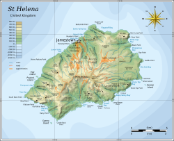
 Map of Saint Helena. | |
 Location of Saint Helena in the South Atlantic Ocean. | |
| തലസ്ഥാനം | Jamestown |
| ഔദ്യോഗിക ഭാഷകൾ | English |
| നിവാസികളുടെ പേര് | Saint Heleniana |
| ഭരണസമ്പ്രദായം | British overseas territory |
• Monarch | Elizabeth II |
• Governor | Mark Andrew Capes |
| Part of St Helena, Ascension and Tristan da Cunha | |
• Charter granted | 1657 |
• Colonised by the East India Company | 1659 |
• Crown colony (Company rule ends) | 22 April 1834[1] |
| 1 September 2009 | |
• ആകെ വിസ്തീർണ്ണം | 121 കി.m2 (47 ച മൈ) |
• 2008 (Feb) census | 4,255[2] |
• ജനസാന്ദ്രത | 35/കിമീ2 (90.6/ച മൈ) |
| നാണയവ്യവസ്ഥ | Saint Helena pound (SHP) |
| സമയമേഖല | UTC+0 (GMT) |
| ഡ്രൈവിങ് രീതി | left |
| കോളിംഗ് കോഡ് | +290 |
| ഇൻ്റർനെറ്റ് ഡൊമൈൻ | .sh |
| |

