സാൻ ഡിയേഗോ കൗണ്ടി
അമേരിക്കൻ ഐക്യനാടുകളിലെ കാലിഫോർണിയ സംസ്ഥാനത്തിൻറെ തെക്കു പടിഞ്ഞാറൻ മൂലയിൽ സ്ഥിതിചെയ്യുന്ന ഒരു കൌണ്ടിയാണ് സാൻ ഡിയേഗോ കൗണ്ടി. 2010 ലെ സെൻസസ് പ്രകാരമുളള ഈ കൗണ്ടിയിലെ ജനസംഖ്യ 3,095,313 ആയിരുന്നു.[5] കാലിഫോർണിയയിൽ ജനസംഖ്യാടിസ്ഥാനത്തിൽ രണ്ടാം സ്ഥാനമുള്ള കൗണ്ടിയും അമേരിക്കൻ ഐക്യനാടുകളിലെ അഞ്ചാമത്തെ ഏറ്റവും ജനസംഖ്യയുള്ള കൗണ്ടിയുമാണ്.
സാൻ ഡിയേഗോ കൗണ്ടി | ||||||||
|---|---|---|---|---|---|---|---|---|
| County of San Diego | ||||||||
| ||||||||
| ||||||||
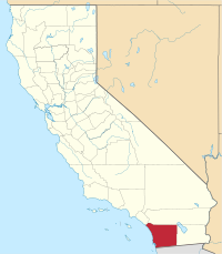 Location in the U.S. state of California | ||||||||
 California's location in the United States | ||||||||
| Coordinates: 33°01′N 116°46′W / 33.02°N 116.77°W | ||||||||
| Country | ||||||||
| State | ||||||||
| Formed | February 18, 1850[1] | |||||||
| നാമഹേതു | San Diego de Alcalá | |||||||
| County seat | San Diego | |||||||
| Largest city | San Diego | |||||||
| • ഭരണസമിതി | Board of Supervisors | |||||||
| • Board of Supervisors[3] |
| |||||||
| • Chief Administrative Officer | Helen Robbins-Meyer[2] | |||||||
| • District Attorney | Summer Stephan | |||||||
| • ആകെ | 4,526 ച മൈ (11,720 ച.കി.മീ.) | |||||||
| • ഭൂമി | 4,207 ച മൈ (10,900 ച.കി.മീ.) | |||||||
| • ജലം | 319 ച മൈ (830 ച.കി.മീ.) | |||||||
| ഉയരത്തിലുള്ള സ്ഥലം | 6,536 അടി (1,992 മീ) | |||||||
| • ആകെ | 30,95,313 | |||||||
| • കണക്ക് (2016) | 33,17,749 | |||||||
| • ജനസാന്ദ്രത | 680/ച മൈ (260/ച.കി.മീ.) | |||||||
| സമയമേഖല | UTC-8 (Pacific Time Zone) | |||||||
| • Summer (DST) | UTC-7 (Pacific Daylight Time) | |||||||
| Area codes | 442/760, 619, 858, and 949 | |||||||
| FIPS code | 06-073 | |||||||
| GNIS feature ID | 277301 | |||||||
| വെബ്സൈറ്റ് | www | |||||||
അമേരിക്കൻ ഐക്യനാടുകളിലെ എട്ടാമത്തെ ഏറ്റവും കൂടുതൽ ജനസംഖ്യയുള്ള നഗരമായ സാൻ ഡിയേഗോയാണ്[6] ഈ കൗണ്ടിയുടെ ആസ്ഥാനം.
അവലംബം
തിരുത്തുക- ↑ "Chronology". California State Association of Counties. Archived from the original on 2016-01-29. Retrieved February 6, 2015.
- ↑ "Chief Administrative Officer". County of San Diego. Retrieved January 31, 2015.
- ↑ "Board of Supervisors". County of San Diego. Retrieved January 12, 2015.
- ↑ "Hot Springs Mountain". Peakbagger.com. Retrieved January 31, 2015.
- ↑ "State & County QuickFacts". United States Census Bureau. Archived from the original on 2011-07-18. Retrieved April 6, 2016.
- ↑ "Find a County". National Association of Counties. Retrieved 2011-06-07.

