റെഡ് ഡീർ
റെഡ് ഡീർ കാനഡയിലെ ആൽബെർട്ട പ്രവിശ്യയിൽ കാൽഗറി-എഡ്മണ്ടൻ ഇടനാഴിയുടെ മധ്യത്തിൽ സ്ഥിതി ചെയ്യുന്ന ഒരു നഗരമാണ്. മദ്ധ്യ ആൽബെർട്ടയിലുൾപ്പെട്ട[10] റെഡ് ഡീർ നഗരത്തിലെ പ്രധാന വ്യവസായങ്ങളിൽ ആരോഗ്യ സംരക്ഷണം, ചില്ലറ വ്യാപാരം, നിർമ്മാണം, എണ്ണ, വാതകം, ഹോസ്പിറ്റാലിറ്റി, നിർമ്മാണം, വിദ്യാഭ്യാസം എന്നിവ ഉൾപ്പെടുന്നു.[11] റെഡ് ഡീർ കൗണ്ടിയാൽ വലയം ചെയ്യപ്പെട്ടിരിക്കുന്ന അത്, ലാകോംബെ കൗണ്ടിയുമായി അതിർത്തി പങ്കുവയ്ക്കുന്നു. റെഡ് ഡീർ നദിയോരത്ത്, മലനിരകളുടെ പ്രദേശമായ ആസ്പൻ പാർക്ക്ലാൻറ് പ്രദേശത്താണ് നഗരം സ്ഥിതിചെയ്യുന്നത്.
റെഡ് ഡീർ | |||||
|---|---|---|---|---|---|
City | |||||
| City of Red Deer | |||||
| |||||
| Motto(s): വിദ്യാഭ്യാസം, വ്യവസായം, പുരോഗതി | |||||
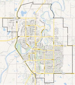
 City boundaries | |||||
| ലുവ പിഴവ് ഘടകം:Location_map-ൽ 522 വരിയിൽ : Unable to find the specified location map definition: "Module:Location map/data/CAN AB Red Deer" does not exist | |||||
| Coordinates: 52°16′05″N 113°48′40″W / 52.26806°N 113.81111°W | |||||
| Country | Canada | ||||
| Province | Alberta | ||||
| Planning region | Red Deer | ||||
| Municipal district | Red Deer County | ||||
| Founded | 1882 | ||||
| Incorporated[1] | |||||
| • Village | May 31, 1894 | ||||
| • Town | June 12, 1901 | ||||
| • City | March 25, 1913 | ||||
| നാമഹേതു | Red Deer River | ||||
| • Mayor | Ken Johnston | ||||
| • Governing body |
| ||||
| • City Manager | Tara Lodewyk | ||||
| • MPs | Earl Dreeshen (CPC), Blaine Calkins (CPC) | ||||
| • MLAs | Jason Stephan (UCP), Adriana LaGrange (UCP) | ||||
(2021)[3] | |||||
| • ഭൂമി | 104.34 ച.കി.മീ.(40.29 ച മൈ) | ||||
| • നഗരം | 65.93 ച.കി.മീ.(25.46 ച മൈ) | ||||
| • മെട്രോ | 104.34 ച.കി.മീ.(40.29 ച മൈ) | ||||
| ഉയരം | 855 മീ(2,805 അടി) | ||||
| • City | 1,00,844 | ||||
| • ജനസാന്ദ്രത | 966.5/ച.കി.മീ.(2,503/ച മൈ) | ||||
| • നഗരപ്രദേശം | 99,846 | ||||
| • നഗര സാന്ദ്രത | 1,514.4/ച.കി.മീ.(3,922/ച മൈ) | ||||
| • മെട്രോപ്രദേശം | 1,00,844 | ||||
| • മെട്രോ സാന്ദ്രത | 966.5/ച.കി.മീ.(2,503/ച മൈ) | ||||
| • Municipal census (2019) | 1,01,002[5] | ||||
| • Estimate (2020) | 1,06,736[6] | ||||
| Demonym(s) | Red Deerian[9] | ||||
| സമയമേഖല | UTC−7 (MST) | ||||
| • Summer (DST) | UTC−6 (MDT) | ||||
| Forward sortation areas | |||||
| ഏരിയ കോഡ് | 403, 587, 825, 368 | ||||
| Highways | 2, 2A, 11, 11A, 595 | ||||
| Waterways | Red Deer River, Waskasoo Creek, Piper Creek | ||||
| വെബ്സൈറ്റ് | reddeer.ca | ||||
അവലംബം
തിരുത്തുക- ↑ "Location and History Profile: City of Red Deer" (PDF). Alberta Municipal Affairs. June 17, 2016. p. 99. Retrieved June 18, 2016.
- ↑ "Municipal Officials Search". Alberta Municipal Affairs. സെപ്റ്റംബർ 22, 2017. Retrieved സെപ്റ്റംബർ 25, 2017.
- ↑ ഉദ്ധരിച്ചതിൽ പിഴവ്: അസാധുവായ
<ref>ടാഗ്;2021censusഎന്ന പേരിലെ അവലംബങ്ങൾക്ക് എഴുത്തൊന്നും നൽകിയിട്ടില്ല. - ↑ "Alberta Private Sewage Systems 2009 Standard of Practice Handbook: Appendix A.3 Alberta Design Data (A.3.A. Alberta Climate Design Data by Town)" (PDF) (PDF). Safety Codes Council. January 2012. pp. 212–215 (PDF pages 226–229). Archived from the original (PDF) on October 16, 2013. Retrieved October 9, 2013.
- ↑ ഉദ്ധരിച്ചതിൽ പിഴവ്: അസാധുവായ
<ref>ടാഗ്;2019censusഎന്ന പേരിലെ അവലംബങ്ങൾക്ക് എഴുത്തൊന്നും നൽകിയിട്ടില്ല. - ↑ "Census Subdivision (Municipal) Population Estimates, July 1, 2016 to 2020, Alberta". Alberta Municipal Affairs. March 23, 2021. Retrieved October 7, 2021.
- ↑ "Population and dwelling counts: Canada and population centres". Statistics Canada. February 9, 2022. Retrieved February 13, 2022.
- ↑ "Population and dwelling counts: Canada, provinces and territories, census metropolitan areas and census agglomerations". Statistics Canada. February 9, 2022. Retrieved February 13, 2022.
- ↑ "Red Deerian Comes Out on Top". City of Red Deer. 2009-07-08. Archived from the original on 2012-07-18. Retrieved 2011-06-07.
- ↑ "Red Deer boasts an immediate trade area of over 312,700 people...""Why Red Deer," City of Red Deer. Retrieved May 8, 2022.
- ↑ City of Red Deer, "Key Industries," Retrieved May 8, 2022.


