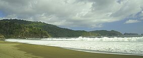
മെരു ബെട്ടിരി ദേശീയോദ്യാനം
മെരു ബെട്ടിരി ദേശീയോദ്യാനം ഇൻഡോനേഷ്യയിലെ കിഴക്കൻ ജാവയിലെ ഒരു ദേശീയോദ്യാനമാണ്. 580 ചതുരശ്ര കിലോമീറ്റർ പ്രദേശത്ത് വ്യാപിച്ചു കിടക്കുന്ന ഇതിലെ 8.45 ചതുരശ്ര കിലോമീറ്റർ ഭാഗം സമുദ്രമേഖലയാണ്.[2] കടലാമകളിലെ വംശനാശഭീഷണി നേരിടുന്ന ഇനങ്ങളായ ലെതർബാക്ക് കടലാമകൾ, ഹാക്സ്ബിൽ കടലാമകൾ, ഗ്രീൻ കടലാമകൾ, ഒലീവ് റിഡ്ലി കടലാമകൾ എന്നിവയുടെ മുട്ടയിടൽ കേന്ദ്രമാണ് ഈ ദേശീയോദ്യാനത്തിലെ ബീച്ചുകൾ.[3]
| Meru Betiri National Park | |
|---|---|
| Taman Nasional Meru Betiri | |
ഐ.യു.സി.എൻ. ഗണം II (ദേശീയോദ്യാനം) | |
 Bandealit Beach | |
| ലുവ പിഴവ് ഘടകം:Location_map-ൽ 522 വരിയിൽ : Unable to find the specified location map definition: "Module:Location map/data/Java Topography" does not exist | |
| Location | East Java, Indonesia |
| Nearest city | Jember |
| Coordinates | 8°32′S 113°47′E / 8.533°S 113.783°E |
| Area | 580 കി.m2 (220 ച മൈ) |
| Established | 1982 |
| Visitors | 2,486 (in 2006)[1] |
| Governing body | Ministry of Environment and Forestry |
അവലംബം
തിരുത്തുക- ↑ "Forestry statistics of Indonesia 2007" (PDF). Archived (PDF) from the original on 2011-07-22. Retrieved 20 May 2010.
- ↑ "Meru Betiri National Park Management Authority". Archived from the original on 2009-12-04. Retrieved 2010-01-11.
- ↑ "Ministry of Forestry: Meru Betiri NP". Archived from the original on 2010-02-10. Retrieved 2010-01-11.