ഫ്രാസർ നദി
ഫ്രാസർ നദി, കാനഡയിൽ ബ്രിട്ടീഷ് കൊളമ്പിയയിലെ ഏറ്റവും ദൈർഘ്യമേറിയ നദിയാണ്. റോക്കി മലനിരകളിലെ ബ്ലാക്ൿറോക്ക് മലനിരകൾക്ക് സമീപത്തുള്ള ഫ്രാസർ പാസിൽനിന്ന് ഉത്ഭവിക്കുന്ന ഈ നദി 1,375 കിലോമീറ്റർ (854 മൈൽ) ദൂരം സഞ്ചരിച്ച്, വാൻകൂവറിനു സമീപം ജോർജിയ കടലിടുക്കിലേക്ക് പതിക്കുന്നു.[8] ഇത് കാനഡയിലെ പത്താം സ്ഥാനമുള്ള ഏറ്റവും ദൈർഘ്യമേറിയ നദിയാണ്.[9]
| ഫ്രാസർ നദി | |
| Staulo[1], Lhtako[2], Tacoutche Tesse[3], ʔElhdaqox[4], Sto:lo | |
The Fraser River, from the grounds of Westminster Abbey, above Hatzic in Mission, British Columbia, looking upstream (E)
| |
| Name origin: Fur trader and explorer Simon Fraser | |
| രാജ്യം | Canada |
|---|---|
| Province | British Columbia |
| Regional District |
Fraser-Fort George, Cariboo, Thompson-Nicola, Squamish-Lillooet, Fraser Valley, and Greater Vancouver |
| പോഷക നദികൾ | |
| - ഇടത് | Bowron River, Willow River, Quesnel River, Thompson River, Coquihalla River, Chilliwack River |
| - വലത് | Morkill River, McGregor River, Salmon River, Nechako River, West Road (Blackwater) River, Chilcotin River, Bridge River, Harrison River, Stave River, Pitt River, Coquitlam River |
| പട്ടണങ്ങൾ | McBride, BC, Prince George, BC, Quesnel, BC, Hope, BC, Chilliwack, BC, Abbotsford, BC, Vancouver, BC |
| സ്രോതസ്സ് | Fraser Pass |
| - സ്ഥാനം | Rocky Mountains, Mount Robson Provincial Park, British Columbia, Canada |
| - ഉയരം | 2,145 മീ (7,037 അടി) |
| - നിർദേശാങ്കം | 53°4′44.2″N 119°7′9.7″W / 53.078944°N 119.119361°W |
| അഴിമുഖം | Fraser River Delta |
| - സ്ഥാനം | Strait of Georgia, Vancouver, British Columbia, Canada |
| - ഉയരം | 0 മീ (0 അടി) |
| - നിർദേശാങ്കം | 49°10′40″N 123°12′45″W / 49.17778°N 123.21250°W |
| നീളം | 1,375 കി.മീ (854 മൈ) [5] |
| നദീതടം | 220,000 കി.m2 (84,942 ച മൈ) |
| Discharge | for mouth (average and min); max at Hope |
| - ശരാശരി | 3,475 m3/s (122,718 cu ft/s) [6][7] |
| - max | 17,000 m3/s (600,349 cu ft/s) |
| - min | 575 m3/s (20,306 cu ft/s) |
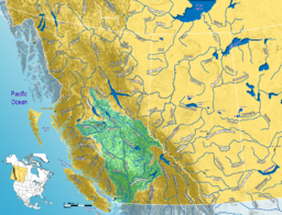
Fraser River watershed
| |
പേരിൻറെ ഉത്ഭവം
തിരുത്തുക1808 ൽ നോർത്ത് വെസ്റ്റ് കമ്പനിയ്ക്കുവേണ്ടി, ഇന്നത്തെ പ്രിൻസ് ജോർജ്ജ് സൈറ്റിൽനിന്ന് ഏറെക്കുറെ ഈ നദീമുഖത്തേയ്ക്കു നടത്തപ്പെട്ട പര്യവേക്ഷണ സംഘത്തെ നയിച്ചിരുന്ന സൈമൺ ഫ്രാസർ എന്നയാളുടെ പേരാണ് ഈ നദിക്ക് നൽകപ്പെട്ടത്.
അവലംബം
തിരുത്തുക- ↑ Salishan languages and Chinook Jargon. The Halkomelem form is Sto:lo, used as the name of the people of the Fraser Valley stretch of the river. "Staulo" is the anglicization used in the Kamloops Wawa lexicon of the Chinook Jargon
- ↑ Carrier language. Lhtako is also used to mean the Dakelh people of the Quesnel/North Cariboo area
- ↑ Indigenous name recorded by Alexander Mackenzie on expedition to find Columbia River’s headwaters; circa 18-?
- ↑ Tsilhqot'in name meaning Sturgeon (ʔElhdachogh) River (Yeqox)
- ↑ "Fraser River Fact Sheet". Canadian Heritage Rivers System. Archived from the original on 2017-07-12. Retrieved December 2, 2016.
- ↑ Ambient Water Quality Assessment and Objectives for the Fraser River sub-basin from Kanaka Creek to the Mouth Archived 2016-03-04 at the Wayback Machine., BC Ministry of Environment
- ↑ ഉദ്ധരിച്ചതിൽ പിഴവ്: അസാധുവായ
<ref>ടാഗ്;reviewഎന്ന പേരിലെ അവലംബങ്ങൾക്ക് എഴുത്തൊന്നും നൽകിയിട്ടില്ല. - ↑ "Fraser River". BC Geographical Names.
- ↑ Canadian Global Almanac. John Wiley and Sons. 2004

