പ്രമാണം:Map of tropical cyclone affected areas.png

ഈ പ്രിവ്യൂവിന്റെ വലിപ്പം: 800 × 371 പിക്സലുകൾ. മറ്റ് റെസലൂഷനുകൾ: 320 × 148 പിക്സലുകൾ | 640 × 296 പിക്സലുകൾ | 1,347 × 624 പിക്സലുകൾ.
പൂർണ്ണ വലിപ്പം (1,347 × 624 പിക്സൽ, പ്രമാണത്തിന്റെ വലിപ്പം: 94 കെ.ബി., മൈം തരം: image/png)
| ഈ പ്രമാണം വിക്കിമീഡിയ കോമൺസിൽ നിന്നുള്ളതാണ്. പ്രമാണത്തെക്കുറിച്ചുള്ള വിവരണം താഴെ കൊടുത്തിരിക്കുന്നു.
|
| വിവരണം |
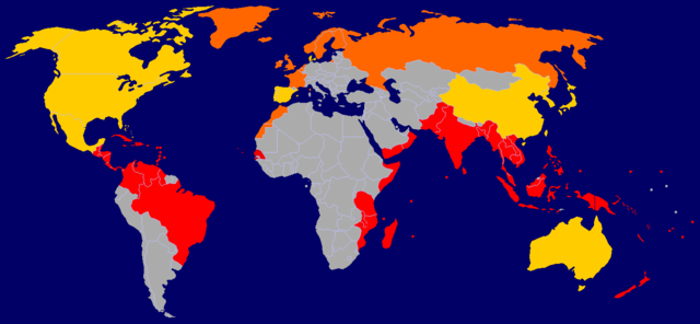
A map of tropical cyclone affected areas. Based off Image:BlankMap-World-v5.png and overlaid with Image:Ocean-layer BlankMap-World.png. Information based mainly off Image:Global tropical cyclone tracks.jpg. Fully-tropical cyclones have affected these nations/territories.
Both fully-tropical cyclones, as well as extratropical remnants of tropical cyclones, have affected these areas.
Extratropical remnants of tropical cyclones have affected these areas.
This is by no means a fully-complete map, and may contain errors. |
||||||||
| തീയതി |
2006-09-29 Updated: 2006-09-30 Updated: 2006-12-23 Updated: 2007-04-09 |
||||||||
| സ്രോതസ്സ് | Self-work | ||||||||
| സ്രഷ്ടാവ് | User:NSLE-Chacor | ||||||||
| അനുമതി (ഈ പ്രമാണത്തിന്റെ പുനരുപയോഗം) |
|

പ്രമാണ നാൾവഴി
ഏതെങ്കിലും തീയതി/സമയ കണ്ണിയിൽ ഞെക്കിയാൽ പ്രസ്തുതസമയത്ത് ഈ പ്രമാണം എങ്ങനെയായിരുന്നു എന്നു കാണാം.
| തീയതി/സമയം | ലഘുചിത്രം | അളവുകൾ | ഉപയോക്താവ് | അഭിപ്രായം | |
|---|---|---|---|---|---|
| നിലവിലുള്ളത് | 16:08, 9 ഏപ്രിൽ 2007 | | 1,347 × 624 (94 കെ.ബി.) | NSLE-Chacor | Background changed to blue, Panama back to red |
| 12:19, 23 ഡിസംബർ 2006 |  | 1,347 × 624 (93 കെ.ബി.) | NSLE-Chacor | Further update using Image:Global tropical cyclone tracks.jpg - two countries changed to grey (unaffected), Senegal added in tropical | |
| 12:08, 23 ഡിസംബർ 2006 |  | 1,347 × 624 (93 കെ.ബി.) | NSLE-Chacor | Fixed stray blues not changed in colour scheme change | |
| 12:06, 23 ഡിസംബർ 2006 |  | 1,347 × 624 (93 കെ.ബി.) | NSLE-Chacor | update: Colour change, Mexico, Bahamas and Taiwan to both tropical and extratropical | |
| 05:04, 30 സെപ്റ്റംബർ 2006 |  | 1,347 × 624 (130 കെ.ബി.) | NSLE-Chacor | Update: Denmark changed to green (Faeroe Islands affected by w:Hurricane Faith while tropical); Australia changed to green (extratropical remnants recorded). | |
| 06:15, 29 സെപ്റ്റംബർ 2006 |  | 1,347 × 624 (130 കെ.ബി.) | NSLE-Chacor | {{Information |Description= A map of tropical cyclone affected areas. Based off Image:BlankMap-World-v5.png and overlaid with Image:Ocean-layer BlankMap-World.png. Aqua-coloured nations/territories indicate that fully-tropical cyclones have affe |
പ്രമാണത്തിന്റെ ഉപയോഗം
താഴെ കാണുന്ന താളിൽ ഈ ചിത്രം ഉപയോഗിക്കുന്നു:
പ്രമാണത്തിന്റെ ആഗോള ഉപയോഗം
താഴെ കൊടുത്തിരിക്കുന്ന മറ്റ് വിക്കികൾ ഈ പ്രമാണം ഉപയോഗിക്കുന്നു:
- el.wikipedia.org സംരംഭത്തിലെ ഉപയോഗം
- en.wikipedia.org സംരംഭത്തിലെ ഉപയോഗം
- pt.wikipedia.org സംരംഭത്തിലെ ഉപയോഗം