പ്രമാണം:COVID-19 Outbreak World Map.svg

പൂർണ്ണ വലിപ്പം (എസ്.വി.ജി. പ്രമാണം, നാമമാത്രമായ 2,921 × 1,500 പിക്സലുകൾ, പ്രമാണത്തിന്റെ വലിപ്പം: 1.72 എം.ബി.)
| ഈ പ്രമാണം വിക്കിമീഡിയ കോമൺസിൽ നിന്നുള്ളതാണ്. പ്രമാണത്തെക്കുറിച്ചുള്ള വിവരണം താഴെ കൊടുത്തിരിക്കുന്നു.
|

|
ഈ പ്രമാണം ഏറ്റവും പുതിയ വിവരങ്ങൾ ചേർത്ത് പുതുക്കേണ്ടതായിരിക്കാം. പുതിയ കാര്യങ്ങൾ ഉൾപ്പെടാത്ത വിധത്തിൽ ഒരു പ്രത്യേക പതിപ്പ് ഉപയോഗിക്കാനാണ് താങ്കൾ ആഗ്രഹിക്കുന്നതെങ്കിൽ, ദയവായി ആവശ്യമായ പതിപ്പ് മറ്റൊരു പ്രമാണം ആയി അപ്ലോഡ് ചെയ്യുക. |
ചുരുക്കം
| വിവരണം |
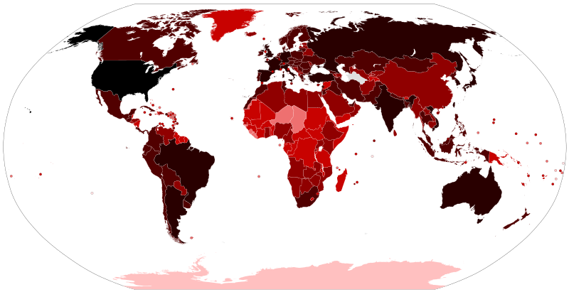
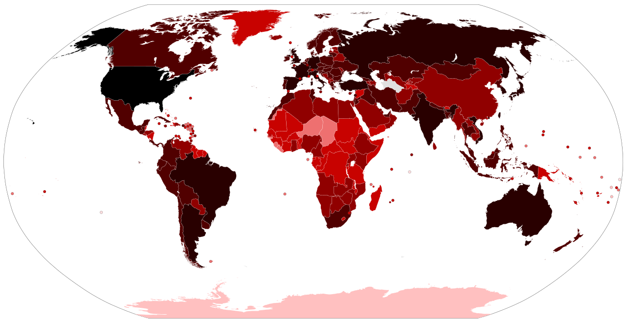
Map of the COVID-19 outbreak. Total cumulative confirmed COVID-19 cases by country. See the file history farther down for the latest upload date. Be aware that since this is a rapidly evolving situation, new cases may not be immediately represented visually. Refer to the primary article COVID-19 pandemic or the World Health Organization's situation reports for most recent reported case information. Legend information: 100,000,000+ Confirmed cases 10,000,000–99,999,999 Confirmed cases 1,000,000–9,999,999 Confirmed cases 100,000–999,999 Confirmed cases 10,000–99,999 Confirmed cases 1,000–9,999 Confirmed cases 100–999 Confirmed cases 1–99 Confirmed cases No confirmed cases, no population, or no data available |
| തീയതി |
– Date of first upload to the Wikimedia Commons. See the file history farther down for the latest upload date. Update the "point in time" date in the Wikidata entry linked below. {{wikidata|property|Q101240885|P585}} is used in map captions on Wikipedia. It provides the map date. To enable the date change click the purge link after updating the Wikidata entry. |
| സ്രോതസ്സ് |
Latest versions: https://ourworldindata.org/explorers/coronavirus-data-explorer?tab=map&Metric=Confirmed+cases&Interval=Cumulative&Relative+to+Population=false&Align+outbreaks=false&country=~OWID_WRL - Our World in Data. Click on the download tab to download map. The table tab has a table of the exact data by country. Source tab says data is from the COVID-19 Data Repository by the Center for Systems Science and Engineering (CSSE) at Johns Hopkins University. The map at the source is interactive and provides much more detail. For example, run your cursor over the color bar legend to see the countries that apply to that point in the legend. |
| സ്രഷ്ടാവ് |
Various Commons editors. See file history for latest ones. Older versions: Svenskbygderna (original author); Ratherous, AKS471883 (contributors); authors of File:BlankMap-World.svg (source file) |
| മറ്റു പതിപ്പുകൾ |
|
| SVG വികസനം | ഈ എസ്.വി.ജി.യുടെ സ്രോതസ്സ് കോഡ് അസാധു ആണ് കാരണം അതിൽ ഒരു പിഴവ് ഉണ്ട്. ഈ വെക്റ്റർ ചിത്രം സൃഷ്ടിച്ചത് Inkscape ഉപയോഗിച്ചാണ്. |


അനുമതി
- താങ്കൾക്കുള്ള സ്വാതന്ത്ര്യങ്ങൾ:
- പങ്ക് വെയ്ക്കൽ – കൃതി പകർത്താനും, വിതരണം ചെയ്യാനും, പ്രസരിപ്പിക്കാനും
- പുനഃമിശ്രണം ചെയ്യൽ – കൃതി അനുയുക്തമാക്കാൻ
- താഴെ പറയുന്ന ഉപാധികൾ പാലിക്കുക:
- കടപ്പാട് – രചയിതാവോ അനുമതിയുള്ളയാളോ വ്യക്തമാക്കിയിട്ടുള്ള വിധത്തിൽ കൃതിയ്ക്കുള്ള കടപ്പാട് താങ്കൾ നൽകിയിരിക്കണം. താങ്കൾക്കിത് ഏത് വിധത്തിൽ വേണമെങ്കിലും ചെയ്യാവുന്നതാണ്, പക്ഷേ അത് അവർ താങ്കളേയോ താങ്കളുടെ ഉപയോഗത്തേയോ അടിച്ചേൽപ്പിച്ചതു പോലെയാവരുത്.
പ്രമാണ നാൾവഴി
ഏതെങ്കിലും തീയതി/സമയ കണ്ണിയിൽ ഞെക്കിയാൽ പ്രസ്തുതസമയത്ത് ഈ പ്രമാണം എങ്ങനെയായിരുന്നു എന്നു കാണാം.
| തീയതി/സമയം | ലഘുചിത്രം | അളവുകൾ | ഉപയോക്താവ് | അഭിപ്രായം | |
|---|---|---|---|---|---|
| നിലവിലുള്ളത് | 14:21, 14 ജൂൺ 2023 | | 2,921 × 1,500 (1.72 എം.ബി.) | AKS471883 | Macao 10000 |
| 16:55, 25 ഫെബ്രുവരി 2023 |  | 2,921 × 1,500 (1.72 എം.ബി.) | AKS471883 | Taiwan 10000000 | |
| 02:10, 17 ജനുവരി 2023 |  | 2,921 × 1,500 (1.72 എം.ബി.) | AKS471883 | Argentina 10000000 Channel Islands 100000 | |
| 05:56, 24 ഡിസംബർ 2022 |  | 2,921 × 1,500 (1.72 എം.ബി.) | AKS471883 | Tokelau 5 | |
| 03:26, 20 ഡിസംബർ 2022 |  | 2,921 × 1,500 (1.72 എം.ബി.) | AKS471883 | Uruguay 1000000 | |
| 03:02, 16 ഡിസംബർ 2022 |  | 2,921 × 1,500 (1.72 എം.ബി.) | AKS471883 | Mongolia 1000000 | |
| 11:07, 14 ഡിസംബർ 2022 |  | 2,921 × 1,500 (1.72 എം.ബി.) | AKS471883 | Macao 1000 | |
| 05:50, 4 ഡിസംബർ 2022 |  | 2,921 × 1,500 (1.72 എം.ബി.) | AKS471883 | Panama 1000000 | |
| 03:09, 24 നവംബർ 2022 |  | 2,921 × 1,500 (1.72 എം.ബി.) | AKS471883 | GUAM | |
| 16:47, 22 നവംബർ 2022 |  | 2,921 × 1,500 (1.72 എം.ബി.) | S17003 | USA 100000000 |
പ്രമാണത്തിന്റെ ഉപയോഗം
താഴെ കാണുന്ന 2 താളുകളിൽ ഈ ചിത്രം ഉപയോഗിക്കുന്നു:
പ്രമാണത്തിന്റെ ആഗോള ഉപയോഗം
താഴെ കൊടുത്തിരിക്കുന്ന മറ്റ് വിക്കികൾ ഈ പ്രമാണം ഉപയോഗിക്കുന്നു:
- af.wikipedia.org സംരംഭത്തിലെ ഉപയോഗം
- als.wikipedia.org സംരംഭത്തിലെ ഉപയോഗം
- ar.wikipedia.org സംരംഭത്തിലെ ഉപയോഗം
- ar.wikinews.org സംരംഭത്തിലെ ഉപയോഗം
- ast.wikipedia.org സംരംഭത്തിലെ ഉപയോഗം
- az.wikipedia.org സംരംഭത്തിലെ ഉപയോഗം
- be.wikipedia.org സംരംഭത്തിലെ ഉപയോഗം
- bh.wikipedia.org സംരംഭത്തിലെ ഉപയോഗം
- bn.wikipedia.org സംരംഭത്തിലെ ഉപയോഗം
- bs.wikipedia.org സംരംഭത്തിലെ ഉപയോഗം
- ca.wikipedia.org സംരംഭത്തിലെ ഉപയോഗം
- cs.wikipedia.org സംരംഭത്തിലെ ഉപയോഗം
- da.wikipedia.org സംരംഭത്തിലെ ഉപയോഗം
- de.wikipedia.org സംരംഭത്തിലെ ഉപയോഗം
- de.wikinews.org സംരംഭത്തിലെ ഉപയോഗം
- el.wikipedia.org സംരംഭത്തിലെ ഉപയോഗം
- en.wikipedia.org സംരംഭത്തിലെ ഉപയോഗം
- User:LightandDark2000
- User:JeremyNguyenGCI/sandbox
- Wikipedia:Top 25 Report/January 19 to 25, 2020
- COVID-19 pandemic by country and territory
- Talk:COVID-19 pandemic by country and territory/Archive 1
- Wikipedia:Top 25 Report/January 26 to February 1, 2020
- Wikipedia talk:WikiProject Medicine/Archive 132
- Wikipedia:Top 25 Report/February 2 to 8, 2020
- Wikipedia:Top 25 Report/February 9 to 15, 2020
- Wikipedia:Top 25 Report/February 16 to 22, 2020
- Wikipedia:Wikipedia Signpost/2020-03-01/Traffic report
- Wikipedia:Top 25 Report/February 23 to 29, 2020
- Wikipedia:Wikipedia Signpost/Single/2020-03-01
- Wikipedia:Top 25 Report/March 1 to 7, 2020
- Wikipedia:Top 25 Report/March 8 to 14, 2020
- Wikipedia talk:In the news/Archive 74
- Template talk:COVID-19 pandemic/Archive 1
ഈ പ്രമാണത്തിന്റെ കൂടുതൽ ആഗോള ഉപയോഗം കാണുക.