ട്രക്കീ നദി
ട്രക്കീ നദി, അമേരിക്കൻ ഐക്യനാടുകളിലെ കാലിഫോർണിയ, നെവാഡ എന്നീ സംസ്ഥാനങ്ങളിലൂടെ ഒഴുകുന്ന ഒരു നദിയാണ്. വടക്കുകിഴക്കേ ദിശയിലായി ഒഴുകുന്ന ഈ നദിയ്ക്ക് 121 മൈൽ(195 കിലോമീറ്റർ) നീളമുണ്ട്. തഹോ തടാകത്തിന്റെ ഏക ജലനിർഗമനമാർഗ്ഗം ട്രക്കീ നദിയാണ്. ഉന്നത സിയേറ നെവാഡയുടെ ഏതാനും ഭാഗത്തു കൂടി ഒഴുകിപ്പോകുന്ന ട്രക്കീ നദി ഗ്രേറ്റ് ബേസിനിലെ പിരമിഡ് തടാകത്തിൽ പതിക്കുന്നു. അതിന്റെ താഴ്വരകളോടൊപ്പം സമീപ താഴ്വരകളിലെയും ജലസേചനത്തിന്റെ മുഖ്യ സ്രോതസ്സ് ഈ നദിയാണ്.
| ട്രക്കീ നദി | |
| Salmon Trout River[1] | |
The Truckee River just east of Truckee, California
| |
| Name origin: Named after the Paiute chief Truckee | |
| രാജ്യം | United States |
|---|---|
| സംസ്ഥാനങ്ങൾ | California, Nevada |
| സ്രോതസ്സ് | Lake Tahoe |
| - സ്ഥാനം | Sierra Nevada, California |
| - ഉയരം | 6,233 അടി (1,900 മീ) [2] |
| - നിർദേശാങ്കം | 39°10′3″N 120°8′39″W / 39.16750°N 120.14417°W [3] |
| അഴിമുഖം | Pyramid Lake |
| - ഉയരം | 3,793 അടി (1,156 മീ) [3] |
| - നിർദേശാങ്കം | 39°51′27″N 119°26′53″W / 39.85750°N 119.44806°W [3] |
| നീളം | 121 മൈ (195 കി.മീ) [2] |
| നദീതടം | 3,060 ച മൈ (7,925 കി.m2) [4] |
| Discharge | for USGS gage 10350000, Truckee River at Vista, NV |
| - ശരാശരി | 804 cu ft/s (23 m3/s) [5] |
| - max | 17,400 cu ft/s (493 m3/s) |
| - min | 7 cu ft/s (0 m3/s) |
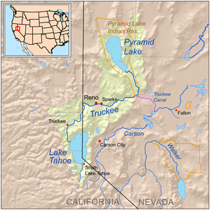
Map of the Pyramid Lake drainage basin
| |
അവലംബം
തിരുത്തുക- ↑ John Charles Fremont (1847). Narrative of the exploring expedition to the Rocky mountains: in the year 1842, and to Oregon and north California in the years 1843–44. Hall & Dickson. p. 309. Retrieved 2010-12-13.
- ↑ 2.0 2.1 ഉദ്ധരിച്ചതിൽ പിഴവ്: അസാധുവായ
<ref>ടാഗ്;NHDഎന്ന പേരിലെ അവലംബങ്ങൾക്ക് എഴുത്തൊന്നും നൽകിയിട്ടില്ല. - ↑ 3.0 3.1 3.2 U.S. Geological Survey Geographic Names Information System: Truckee River
- ↑ ഉദ്ധരിച്ചതിൽ പിഴവ്: അസാധുവായ
<ref>ടാഗ്;rigbyഎന്ന പേരിലെ അവലംബങ്ങൾക്ക് എഴുത്തൊന്നും നൽകിയിട്ടില്ല. - ↑ "Water resources data for the United States, Water Year 2009; gage 10350000, Truckee River at Vista, NV" (PDF). USGS. Retrieved 4 August 2010.

