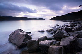
ടാസ്മൻ ദേശീയോദ്യാനം
ടാസ്മൻ ദേശീയോദ്യാനം ആസ്ത്രേലിയയിലെ കിഴക്കൻ ടാസ്മാനിയയിൽ സ്ഥിതിചെയ്യുന്ന ഒരു ദേശീയോദ്യാനമാണ്. ഹോബർട്ടിൽ നിന്നും കിഴക്കായി ഏകദേശം 56 കിലോമീറ്റർ അകലെയാണ് ഇത്. 107.5 ചതുരശ്രകിലോമീറ്റർ പ്രദേശത്തായി ഈ ദേശീയോദ്യാനം വ്യാപിച്ചു കിടക്കുന്നു. ഫോറെസ്റ്റിയർ-ടാസ്മാൻ ഉപദ്വീപുകളുടെ ഭാഗങ്ങളിലാണ് ഈ ദേശീയോദ്യാനത്തിന്റെ സ്ഥാനം. ടാസ്മാൻ ഉപദ്വീപിന്റെ എല്ലാ ഭാഗങ്ങളും ഈ ദേശീയോദ്യാനത്തിൽ ഉൾപ്പെടുന്നു.
| ടാസ്മൻ ദേശീയോദ്യാനം Tasmania | |
|---|---|
ഐ.യു.സി.എൻ. ഗണം II (ദേശീയോദ്യാനം) | |
 Sunrise at Fortescue Bay | |
 Map of Tasman National Park in Tasmania | |
| Nearest town or city | Port Arthur |
| നിർദ്ദേശാങ്കം | 42°51′19″S 147°58′33″E / 42.85528°S 147.97583°E |
| സ്ഥാപിതം | 30 April 1999[1] |
| വിസ്തീർണ്ണം | 107.5 km2 (41.5 sq mi)[1] |
| Managing authorities | Tasmania Parks and Wildlife Service |
| Website | ടാസ്മൻ ദേശീയോദ്യാനം |
| See also | Protected areas of Tasmania |
ചരിത്രം
തിരുത്തുക1999 ഏപ്രിൽ 30ലെ റിജണൽ ഫോറസ്റ്റ് എഗ്രിമെന്റനുസരിച്ചാണ് ഈ ദേശീയോദ്യാനം വിജ്ഞാപനം ചെയ്യപ്പെട്ടത്. [2] ടാസ്മൻ വിളക്കുമാടം ടാസ്മൻ ദ്വീപിലാണ് സ്ഥിതിചെയ്യുന്നത് (1906ലാണ് ഇത് നിർമ്മിച്ചത്). ദേശീയോദ്യാനത്തിന്റെ ഭാഗമാണ് ഇത്. 1977 മുതൽ ഈ വിളക്കുമാടവും കാലാവസ്ഥാനിരീക്ഷണകേന്ദ്രവും ആളൊഴിഞ്ഞുകിടക്കുകയാണ്. [3][4]
ഇതും കാണുക
തിരുത്തുകഅവലംബം
തിരുത്തുകTasman National Park എന്ന വിഷയവുമായി ബന്ധപ്പെട്ട ചിത്രങ്ങൾ വിക്കിമീഡിയ കോമൺസിലുണ്ട്.
- ↑ 1.0 1.1 "Reserve Listing - National Parks". Tasmanian Parks and Wildlife Service Website. Tasmania Parks and Wildlife Service. 17 November 2008. Archived from the original on 2009-10-12. Retrieved 1 May 2010.
- ↑ "Tasman National Park - Highlights". Parks & Wildlife Service Tasmania. Archived from the original on 2017-11-12. Retrieved 23 July 2009.
- ↑ Brothers, Nigel; Pemberton, David; Pryor, Helen; & Halley, Vanessa. (2001). Tasmania’s Offshore Islands: seabirds and other natural features. Tasmanian Museum and Art Gallery: Hobart. ISBN 0-7246-4816-X
- ↑ "Tasman Island Lighthouse". Lighthouses of Tasmania. Lighthouses of Australia Inc.