ടാംപ, ഫ്ലോറിഡ
ടാംപ (/ˈtæmpə/)[11] അമേരിക്കൻ ഐക്യനാടുകളിലെ ഫ്ലോറിഡ സംസ്ഥാനത്ത് ഹിൽസ്ബറോ കൌണ്ടിയിൽ സ്ഥിതിചെയ്യുന്ന ഒരു പ്രധാന നഗരവും ഹിൽസ്ബറോ കൌണ്ടിയുടെ ആസ്ഥാനവുമാണ്. ഫ്ലോറിഡയുടെ പടിഞ്ഞാറൻ കടൽത്തീരത്ത് ടാംപ ഉൾക്കടലിൽ ഗൾഫ് ഓഫ് മെക്സിക്കോയ്ക്കു സമീപം സ്ഥിതിചെയ്യുന്ന ഈ നഗരം ടാംപ ഉൾക്കടൽ മേഖലയിലെ ഏറ്റവും വലിയ നഗരമാണ്. 2010 ലെ യു.എസ്. സെൻസസ് പ്രകാരം നഗരത്തിലെ ആകെ ജനസംഖ്യ 335,709 ആയിരുന്നു. 2016-ൽ ഇത് 377,165 ആയി വർദ്ധിച്ചുവെന്നു കണക്കു കൂട്ടിയിരുന്നു.[12]
ടാംപ, ഫ്ലോറിഡ | |||
|---|---|---|---|
City | |||
| സിറ്റി ഓഫ് ടാംപ | |||
 Images from top, left to right: Skyline of Downtown Tampa, Amalie Arena, Ybor City, Henry B. Plant Museum, Raymond James Stadium, Busch Gardens Tampa | |||
| |||
| Nickname(s): | |||
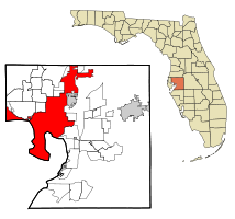
 Location in Hillsborough County and the state of Florida | |||
| Coordinates: 27°58′05″N 82°28′35″W / 27.96806°N 82.47639°W | |||
| Country | |||
| State | |||
| County | |||
| Settled | 1823 | ||
| Incorporated (Village) | January 18, 1849 | ||
| Incorporated (Town) | September 10, 1853 and August 11, 1873 | ||
| Incorporated (City) | December 15, 1855 * and July 15, 1887 | ||
| • Mayor | Bob Buckhorn (D) | ||
| • Legislative | Tampa City Council | ||
| • City | 175.22 ച മൈ (453.81 ച.കി.മീ.) | ||
| • ഭൂമി | 113.42 ച മൈ (293.75 ച.കി.മീ.) | ||
| • ജലം | 61.80 ച മൈ (160.06 ച.കി.മീ.) 35.3% | ||
| • നഗരം | 802.3 ച മൈ (2,078 ച.കി.മീ.) | ||
| • മെട്രോ | 2,554 ച മൈ (6,610 ച.കി.മീ.) | ||
| ഉയരം | 48 അടി (14.6 മീ) | ||
| • City | 3,35,709 | ||
| • കണക്ക് (2016)[6] | 3,77,165 | ||
| • റാങ്ക് | 53rd in the US | ||
| • ജനസാന്ദ്രത | 3,325.47/ച മൈ (1,283.97/ച.കി.മീ.) | ||
| • നഗരപ്രദേശം | 2.4 million (17th) | ||
| • മെട്രോപ്രദേശം | 30,68,511[4] | ||
| Demonym(s) | Tampanian, Tampan[7] | ||
| സമയമേഖല | UTC-5 (EST) | ||
| • Summer (DST) | UTC-4 (EDT) | ||
| ZIP codes | 33601–33626, 33629–33631, 33633–33635, 33637, 33646, 33647, 33650, 33655, 33660–33664, 33672–33675, 33677, 33679–33682, 33684–33689, 33694[8] | ||
| ഏരിയ കോഡ് | 813 | ||
| FIPS code | 12-71000[5] | ||
| GNIS feature ID | 0292005[9] | ||
| വെബ്സൈറ്റ് | www | ||
| * Original city charter revoked by Florida Legislature on October 4, 1869[10] | |||
പുരാവസ്തുശാസ്ത്ര തെളിവുകൾ സൂചിപ്പിക്കുന്നത്, ആയിരക്കണക്കിന് വർഷങ്ങളായി തദ്ദേശീയ ജനത ഇവിടെ താമസിച്ചിരുന്നുെന്നാണ്.
അവലംബം
തിരുത്തുക- ↑ "Ybor City: Cigar Capital of the World". Nps.gov. June 28, 1999. Retrieved July 5, 2013.
- ↑ "Alive: Ybor stumbled upon Guavaween". Sptimes.com. October 29, 1999. Archived from the original on 2015-09-24. Retrieved July 5, 2013.
- ↑ "2016 U.S. Gazetteer Files". United States Census Bureau. Retrieved Jul 7, 2017.
- ↑ "Annual Estimates of the Resident Population: April 1, 2010 to July 1, 2016 - United States -- Metropolitan and Micropolitan Statistical Area; and for Puerto Rico (GCT-PEPANNRES)". American Factfinder. U.S. Census Bureau. Archived from the original on 2020-02-13. Retrieved April 28, 2017.
- ↑ 5.0 5.1 "Geographic Identifiers: 2010 Demographic Profile Data (G001): Tampa city, Florida". American Factfinder. U.S. Census Bureau. Retrieved April 28, 2017.
- ↑ ഉദ്ധരിച്ചതിൽ പിഴവ്: അസാധുവായ
<ref>ടാഗ്;USCensusEst2016എന്ന പേരിലെ അവലംബങ്ങൾക്ക് എഴുത്തൊന്നും നൽകിയിട്ടില്ല. - ↑ Kruse, Michael. "What are you called if you live in Tampa?". Tampa Bay Times. Archived from the original on 2014-04-26. Retrieved April 26, 2014.
- ↑ "Look Up a Zip Code: TAMPA FL". U.S. Postal Service. Retrieved April 28, 2017.
- ↑ "Tampa, Florida". Geographic Names Information System. United States Geological Survey.
- ↑ "John Thomas Lesley – 12th Mayor of Tampa". Archived 2010-07-20 at the Wayback Machine. TampaGov.Retrieved March 22, 2010. Archived July 20, 2010, at the Wayback Machine.
- ↑ "Tampa". The American Heritage Dictionary of the English Language. Houghton Mifflin Harcourt. Retrieved December 4, 2011.
- ↑ "Annual Estimates of the Resident Population for Incorporated Places: April 1, 2010 to July 1, 2015". Archived from the original on June 2, 2016. Retrieved July 2, 2016.


