കുച്ചിങ്ങ്
കുച്ചിങ്ങ് /ˈkuːtʃɪŋ/ (Jawi: کوچيڠ, ചൈനീസ്: 古晉; പിൻയിൻ: Gǔjìn) മലേഷ്യയിലെ സരാവക് സംസ്ഥാനത്തിലെ ഏറ്റവും ജനസാന്ദ്രതയുള്ള നഗരവും സംസ്ഥാന തലസ്ഥാനവും കൂടിയാണ്.[7] ഔദ്യോഗികമായി ഇത് സിറ്റി ഓഫ് കുച്ചിങ്ങ് എന്നറിയപ്പെടുന്നു.[8] കുച്ചിംഗ് ഡിവിഷന്റെ തലസ്ഥാനമാണിത്.
Kuching | |||
|---|---|---|---|
City and State Capital | |||
| Bandar Raya Kuching City of Kuching | |||
| Other transcription(s) | |||
| • Jawi | کوچيڠ | ||
| • Chinese | 古晉 | ||
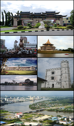
 Clockwise from top right: Chinatown, State Assembly building, Fort Margherita, Pending Bridge, The Astana, Sarawak State Museum and cat statues. | |||
| |||
| Nickname(s): "Cat City", Bandaraya Perpaduan (City of Unity) | |||
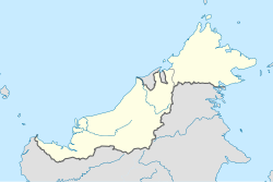
Location in East Malaysia | |||
| Coordinates: 1°33′36″N 110°20′42″E / 1.56000°N 110.34500°E | |||
| Country | |||
| State | |||
| Division | Kuching Division | ||
| District | Kuching District | ||
| Founded by the Sultanate of Brunei | 1827 | ||
| Settled by James Brooke | 18 August 1842 | ||
| Granted municipality status | 1 January 1953 | ||
| Granted city status | 1 August 1988 | ||
| • Mayor of Kuching North | Abang Wahap Abang Julai | ||
| • Mayor of Kuching South | James Chan Khay Syn | ||
| • City of Kuching | [[1 E+8_m²|431.02 ച.കി.മീ.]] (166.42 ച മൈ) | ||
| • മെട്രോ | 2,030.94 ച.കി.മീ.(784.15 ച മൈ) | ||
| • Kuching North | 369.48 ച.കി.മീ.(142.66 ച മൈ) | ||
| • Kuching South | 61.54 ച.കി.മീ.(23.76 ച മൈ) | ||
| Sourced from the DBKU official website | |||
| ഉയരം | 8 മീ(26 അടി) | ||
| ഉയരത്തിലുള്ള സ്ഥലം | 810.2 മീ(2,658.1 അടി) | ||
| താഴ്ന്ന സ്ഥലം | 0 മീ(0 അടി) | ||
(2010)[5] | |||
| • City of Kuching | 325,132 | ||
| • ജനസാന്ദ്രത | 754.33/ച.കി.മീ.(1,953.7/ച മൈ) | ||
| • മെട്രോപ്രദേശം | 684,112 | ||
| • മെട്രോ സാന്ദ്രത | 336.8/ച.കി.മീ.(872/ച മൈ) | ||
| • Demonym | Kuchingite / Orang Kuching | ||
| Sourced from Population and Housing Census of Malaysia 2010. Kuching metropolitan area (Greater Kuching) includes population of 358,980 in the Padawan municipality and Samarahan district.[6] | |||
| സമയമേഖല | UTC+8 (MST) | ||
| • Summer (DST) | UTC+8 (Not observed) | ||
| Postal code | 93xxx | ||
| Area code(s) | 082 (landline only) | ||
| Vehicle registration | QA and QK (for all vehicles except taxis) HQ (for taxis only) | ||
| വെബ്സൈറ്റ് | Kuching North: www Kuching South: www | ||
ബോർണിയോ ദ്വീപിലെ സരാവാക്ക് സംസ്ഥാനത്തിൻറെ തെക്കുപടിഞ്ഞാറൻ അറ്റത്ത്, സരാവക് നദിയുടെ തീരത്താണ് ഈ നഗരം സ്ഥിതി ചെയ്യുന്നത്. 431 ചതുരശ്ര കിലോമീറ്റർ (166 ചതുരശ്ര മൈൽ) പ്രദേശത്തായി വ്യാപിച്ചുകിടക്കുന്ന ഈ നഗരത്തിൻറെ കുച്ചിങ്ങ് നോർത്ത് ഭരണ പ്രദേശത്ത് 165,642 ഉം കുച്ചിംഗ് സൗത്ത് അഡ്മിനിസ്ട്രേറ്റീവ് മേഖലയിൽ 159,490 ഉം ജനങ്ങൾ അധിവസിക്കുന്നു.[5][9][10] രണ്ടു മേഖലയിലെ ആകെ ജനസംഖ്യ ഏകദേശം 325,132 ആണ്.[11]
ബ്രുണൻ സാമ്രാജ്യത്തിൻറെ ഭരണകാലത്ത് 1827-ൽ സരാവാക്കിൻറെ മൂന്നാമത്തെ തലസ്ഥാനമായിരുന്നു കുച്ചിങ്ങ്. ഉൾനാടൻ ബോർണിയോ നിവാസികളായ ദയാക്ക് വിഭാഗത്തിൻറെ കലാപം അടിച്ചമർത്തി ബ്രൂണൻ സാമ്രാജ്യത്തെ സഹായിക്കുന്നതിനുവേണ്ടി, സരവാക്ക് ജയിംസ് ബ്രൂക്കിന് വിട്ടുകൊടുത്തതോടെ 1841 ൽ കുച്ചിങ്ങ് സരാവാക്കിൻറെ തലസ്ഥാനമായിത്തീർന്നു. ഈ ജനങ്ങൾ പിന്നീട് അദ്ദേഹത്തിൻറെ വിശ്വസ്തരായ അനുയായികളായിത്തീർന്നു. ചാൾസ് ബ്രൂക്കിൻറെ ഭരണകാലത്ത് ശുചീകരണ സംവിധാനം, ഹോസ്പിറ്റലുകൾ, ജയിലുകൾ കോട്ടകൊത്തളങ്ങൾ, കമ്പോളങ്ങൾ തുടങ്ങിയവ നിർമ്മിക്കപ്പെട്ടതോടൊപ്പം നഗരത്തിനു പ്രത്യേക ശ്രദ്ധയും അതിൻറെ വികസനവും തുടർന്നുകൊണ്ടിരുന്നു. 1941 ൽ ബ്രൂക്ക് ഭരണകൂടം കുച്ചങ്ങിൽ സെൻറിനറി ആഘോഷം നടത്തിയിരുന്നു. രണ്ടാം ലോകമഹായുദ്ധകാലത്ത് 1942 മുതൽ 1945 വരെയുള്ളകാലഘട്ടത്തിൽ കുച്ചിങ്ങ് ജപ്പാൻ കൈവശപ്പെടുത്തിയിരുന്നു. യുദ്ധത്തടവുകാരെയും സിവിലിയൻ തടവുകാരെയും പാർപ്പിക്കുവാനായി ജാപ്പനീസ് സർക്കാർ കുച്ചിങ്ങിനടുത്തായി ഒരു ബാട്ടു ലിൻറാംഗ് ക്യാമ്പ് രൂപീകരിച്ചിരുന്നു. യുദ്ധത്തിനു ശേഷ നഗരം കേടുപാടുകൾ കൂടാതെ നിലനിന്നു. എന്നിരുന്നാലും, സരാവാക്കിലെ അവസാന രാജാവായിരുന്ന സർ ചാൾസ് വൈനർ ബ്രൂക്ക്, 1946 ൽ ബ്രിട്ടീഷ് ക്രൌൺ കോളനിയുടെ ഭാഗമായി സരാവാക്കിനെ വിട്ടുകൊടുക്കാൻ തീരുമാനിച്ചു.ക്രൗൺ കോളനിയുടെ ഭാഗമായിരുന്ന കാലയളവിലും കുച്ചിംഗ് തലസ്ഥാനമായി തുടർന്നിരുന്നു. 1963 ൽ മലേഷ്യയുടെ രൂപീകരണത്തിനു ശേഷവും കുച്ചിങ്ങ് അതിന്റെ സംസ്ഥാന തലസ്ഥാനമെന്ന സ്ഥാനം നിലനിർത്തുകയും 1988 ൽ നഗര പദവി നൽകപ്പെടുകയും ചെയ്തു. അന്നുമുതൽ, കുച്ചിങ്ങ് നഗരം രണ്ട് വ്യത്യസ്ത പ്രാദേശിക അധികാരികൾ ഭരിക്കുന്ന രണ്ടു വ്യത്യസ്ത ഭരണ പ്രദേശങ്ങളായി വിഭജിക്കപ്പെടുകയും ചെയ്തു. സരാവാക്കിൻറെ ഭരണകേന്ദ്രം കുച്ചിങ്ങിലെ വിസ്മ ബാപ മലേഷ്യയിലാണ് സ്ഥിതിചെയ്യുന്നത്.
സാരാവാക്ക്, ബോർണിയോ എന്നിവ സന്ദർശിക്കുന്ന സഞ്ചാരികൾക്ക് കുച്ചിങ്ങ് ഒരു പ്രവേശന കവാടവും പ്രധാന ഭക്ഷണകേന്ദ്രവുമാണ്.[12]
കുച്ചിംഗ് വെറ്റ്ലാൻഡ്സ് നാഷനൽ പാർക്ക് നഗരത്തിൽ നിന്ന് ഏകദേശം 30 കിലോമീറ്റർ (19 മൈൽ) അകലെയാണ്. ബകോ നാഷണൽ പാർക്ക്, സെമെൻഗോഹ് വന്യജീവി സങ്കേതം, റെയിൻഫോറസ്റ്റ് വേൾഡ് മ്യൂസിക് ഫെസ്റ്റിവൽ (RWMF), സ്റ്റേറ്റ് അസംബ്ലി കെട്ടിടം, ദ അസ്റ്റാന, മാർഗരിറ്റ കോട്ട, കുച്ചിംഗ് കാറ്റ് മ്യൂസിയം, സരാവാക് സ്റ്റേറ്റ് മ്യൂസിയം തുടങ്ങി അനേകം വിനോദ സഞ്ചാര ആകർഷണകേന്ദ്രങ്ങൾ ഇവിടെയുണ്ട്. കിഴക്കൻ മലേഷ്യയിലെ ഒരു പ്രധാന വ്യാവസായിക വാണിജ്യ കേന്ദ്രങ്ങളിലൊന്നാണ് ഈ നഗരം.[13][14]
പേരിൻറെ ഉത്ഭവം
തിരുത്തുക"കുച്ചിങ്ങ്" എന്ന പേര് ബ്രൂക്ക് 1841 ൽ ഇവിടെ എത്തുന്ന കാലത്തുതന്നെ ഉപയോഗത്തിലുണ്ടായിരുന്നു.[15][16] "കുച്ചിങ്ങ്" എന്ന പേരു നിലവിൽവന്നതിനെക്കുറിച്ച് പല സിദ്ധാന്തങ്ങളുമുണ്ട്. ഒരുപക്ഷേ ഇത് മലയൻ ഭാഷയിൽ പൂച്ചയ്ക്കു പറയുന്ന "kucing" എന്ന വാക്കോ അല്ലെങ്കിൽ ചൈനയിലും ബ്രിട്ടീഷ് ഇന്ത്യയിലും വ്യാപാര തുറമുഖത്തെക്കുറിച്ച് സൂചിപ്പിക്കുവാൻ ഉപയോഗിച്ചിരുന്ന ഒരു സാധാരണ പദമായ മലബാർ തീരത്തെ ഇന്ത്യൻ തുറമുഖ തുറമുഖമായ കൊച്ചിഎന്ന വാക്കിൽനിന്നോ ഇത് ഉത്ഭവിച്ചുവെന്ന് അനുമാനിക്കപ്പെടുന്നു.[17]
അവലംബം
തിരുത്തുക- ↑ "Briefing By The Mayor of Kuching North". Kuching North City Hall. Economic Planning Unit (Prime Minister's Department Malaysia). Archived from the original on 2013-12-19. Retrieved 19 December 2013.
- ↑ "Kuching, Malaysia - Weather History and Climate Data". World Climate. Archived from the original on 1 December 2014. Retrieved 28 March 2015.
- ↑ "Malaysia Elevation Map (Elevation of Kuching)". Flood Map : Water Level Elevation Map. Archived from the original on 22 August 2015. Retrieved 22 August 2015.
- ↑ ഉദ്ധരിച്ചതിൽ പിഴവ്: അസാധുവായ
<ref>ടാഗ്;Santubongഎന്ന പേരിലെ അവലംബങ്ങൾക്ക് എഴുത്തൊന്നും നൽകിയിട്ടില്ല. - ↑ 5.0 5.1 "Population Distribution by Local Authority Areas and Mukims, 2010 (page 1 & 8)" (PDF). Department of Statistics, Malaysia. Archived from the original (PDF) on 5 February 2015. Retrieved 19 July 2013.
- ↑ ഉദ്ധരിച്ചതിൽ പിഴവ്: അസാധുവായ
<ref>ടാഗ്;PBTSarawakഎന്ന പേരിലെ അവലംബങ്ങൾക്ക് എഴുത്തൊന്നും നൽകിയിട്ടില്ല. - ↑ Oxford Business Group. The Report: Sarawak 2011. Oxford Business Group. pp. 13–. ISBN 978-1-907065-47-7. Retrieved 18 July 2013.
{{cite book}}:|author=has generic name (help) - ↑ "City of Kuching Ordinance" (PDF). Sarawak State Attorney-General's Chambers. 1988. p. 3 (Chapter 48).
- ↑ Trudy Ring; Robert M. Salkin; Sharon La Boda (January 1996). International Dictionary of Historic Places: Asia and Oceania. Taylor & Francis. pp. 497–498. ISBN 978-1-884964-04-6.
- ↑ Britt Bunyard (6 March 2000). Walking to Singapore. iUniverse. pp. 223–. ISBN 978-0-595-00086-9.
- ↑ "Population Distribution by Local Authority Areas and Mukims, 2010 (page 1 & 8)" (PDF). Department of Statistics, Malaysia. Archived from the original (PDF) on 5 February 2015. Retrieved 19 July 2013.
- ↑ Britt Bunyard (6 March 2000). Walking to Singapore. iUniverse. pp. 223–. ISBN 978-0-595-00086-9.
- ↑ Raymond Frederick Watters; T. G. McGee (1997). Asia-Pacific: New Geographies of the Pacific Rim. Hurst & Company. pp. 311–. ISBN 978-1-85065-321-9.
- ↑ Oxford Business Group (2008). The Report: Sarawak 2008. Oxford Business Group. pp. 30, 56, 69 & 136. ISBN 978-1-902339-95-5.
{{cite book}}:|author=has generic name (help) - ↑ Trudy Ring; Robert M. Salkin; Sharon La Boda (January 1996). International Dictionary of Historic Places: Asia and Oceania. Taylor & Francis. pp. 497–498. ISBN 978-1-884964-04-6.
- ↑ Trudy Ring; Noelle Watson; Paul Schellinger (12 November 2012). Asia and Oceania: International Dictionary of Historic Places. Routledge. pp. 866–. ISBN 978-1-136-63979-1. Retrieved 18 July 2013.
- ↑ Trudy Ring; Robert M. Salkin; Sharon La Boda (January 1996). International Dictionary of Historic Places: Asia and Oceania. Taylor & Francis. pp. 497–498. ISBN 978-1-884964-04-6.


