അമഡോർ കൗണ്ടി
അമഡോർ കൗണ്ടി, അമേരിക്കൻ ഐക്യനാടുകളിലെ കാലിഫോർണിയ സംസ്ഥാനത്ത്, സിയേറാ നെവാഡയിൽ സ്ഥിതിചെയ്യുന്ന ഒരു കൗണ്ടിയാണ്. ഔദ്യോഗികമായി ഇത് കൗണ്ടി ഓഫ് അമഡോർ എന്നറിയപ്പെടുന്നു. 2010 ലെ സെൻസസ് പ്രകാരമുള്ള ഈ കൗണ്ടിയിലെ ജനസംഖ്യ 38,091 ആയിരുന്നു.[4] കൗണ്ടി സീറ്റ് ജാക്സൺ നഗരത്തിലാണു സ്ഥിതി ചെയ്യുന്നത്.[5]
അമഡോർ കൗണ്ടി, കാലിഫോർണിയ | |||
|---|---|---|---|
| County of Amador | |||
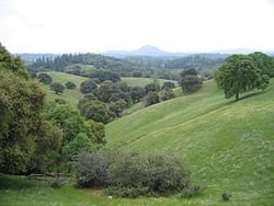
 The Amador County foothills in April 2007 | |||
| |||
| Nickname(s): "The Heart of the Mother Lode" | |||
 Location in the state of California | |||
 California's location in the United States | |||
| Country | |||
| State | |||
| Region | Sierra Nevada | ||
| Incorporated | May 1, 1854[1] | ||
| നാമഹേതു | José María Amador | ||
| County seat | Jackson | ||
| Largest city | Ione (population and area) | ||
| • ആകെ | 606 ച മൈ (1,570 ച.കി.മീ.) | ||
| • ഭൂമി | 595 ച മൈ (1,540 ച.കി.മീ.) | ||
| • ജലം | 11.4 ച മൈ (30 ച.കി.മീ.) | ||
| ഉയരത്തിലുള്ള സ്ഥലം | 9,414 അടി (2,869 മീ) | ||
| • ആകെ | 38,091 | ||
| • കണക്ക് (2016)[3] | 37,383 | ||
| • ജനസാന്ദ്രത | 63/ച മൈ (24/ച.കി.മീ.) | ||
| സമയമേഖല | UTC-8 (Pacific Time Zone) | ||
| • Summer (DST) | UTC-7 (Pacific Daylight Time) | ||
| Area code | 209 | ||
| FIPS code | 06-005 | ||
| GNIS feature ID | 1675841 | ||
| വെബ്സൈറ്റ് | www | ||
ചരിത്രം
തിരുത്തുക1854 മേയ് 11 ന് കാലിഫോർണിയ നിയമനിർമ്മാണസഭ അമഡോർ കൗണ്ടി രൂപീകരിച്ചു.[6] ഈ കൗണ്ടി പിന്നീട് അമഡോർ, കലവെറാസ്, എൽ ഡൊറാഡോ എന്നീ കൗണ്ടികൾ എന്നീ കൌണ്ടികളായി വിഭജിക്കപ്പെട്ടു. 1854 ജൂലൈ 3 ന് ഈ കൌണ്ടി പുനസംഘടിപ്പിക്കപ്പെട്ടു.[7] 1864-ൽ കൌണ്ടിയുടെ ഭൂപ്രദേശത്തിൻറെ ഒരു ഭാഗം അൽപൈൻ കൗണ്ടിയിലേയ്ക്കു കൂട്ടിച്ചേർക്കപ്പെട്ടു.
ഭൂമിശാസ്ത്രം
തിരുത്തുകഅമേരിക്കൻ ഐക്യനാടുകളിലെ സെൻസസ് ബ്യൂറോയുടെ കണക്കനുസരിച്ച് ഈ കൗണ്ടിയുടെ വിസ്തീർണ്ണം ഏകദേശം 606 ചതുരശ്ര മൈൽ (1,570 ചതുരശ്ര കിലോമീറ്റർ) ആണ്. ഇതിൽ 595 ചതുരശ്ര മൈൽ (1,540 ചതുരശ്ര കിലോമീറ്റർ) പ്രദേശം കര ഭൂമിയും 11.4 ചതുരശ്ര മൈൽ (30 ചതുരശ്ര കിലോമീറ്റർ) പ്രദേശം അതായത് (1.9 ശതമാനം) ഭാഗം ജലം ഉൾപ്പെട്ടതുമാണ്.[8]
അവലംബം
തിരുത്തുക- ↑ "Amador County". Geographic Names Information System. United States Geological Survey. Retrieved February 10, 2015.
- ↑ "Thunder Mountain". Peakbagger.com. Retrieved February 10, 2015.
- ↑ 3.0 3.1 "Annual Estimates of the Resident Population: April 1, 2010 to July 1, 2016 Estimates". Archived from the original on 2018-07-14. Retrieved April 27, 2017. Archived 2020-02-12 at Archive.is
- ↑ "State & County QuickFacts". United States Census Bureau. Archived from the original on 2011-07-06. Retrieved April 3, 2016.
- ↑ "Find a County". National Association of Counties. Archived from the original on May 31, 2011. Retrieved June 7, 2011.
- ↑ Whittle, Syd (September 8, 2008). "1854 · Amador County · 1954". The Historical Marker Database. J. J. Prats. Archived from the original on 2014-07-08. Retrieved May 14, 2012. (historical marker placed by Board of Supervisors and Amador County Historical Society, 1954)
- ↑ Whittle, Syd (September 8, 2008). "1854 · Amador County · 1954". The Historical Marker Database. J. J. Prats. Archived from the original on 2014-07-08. Retrieved May 14, 2012. (historical marker placed by Board of Supervisors and Amador County Historical Society, 1954)
- ↑ "2010 Census Gazetteer Files". United States Census Bureau. August 22, 2012. Retrieved September 24, 2015.

