പൂർണ്ണ വലിപ്പം(2,007 × 2,161 പിക്സൽ, പ്രമാണത്തിന്റെ വലിപ്പം: 1.34 എം.ബി., മൈം തരം: image/png)

ഈ map ചിത്രം വെക്റ്റർ ഗ്രാഫിക്സ് ഉപയോഗിച്ച് എസ്.വി.ജി. പ്രമാണമായി പുനർനിർമ്മിക്കേണ്ടതാണ്. അങ്ങനെ ചെയ്യുന്നതുകൊണ്ട് പല ഗുണങ്ങളുമുണ്ട്; കൂടുതൽ വിവരങ്ങൾക്ക് മെച്ചപ്പെടുത്തുവാനുള്ള മീഡിയകൾ കാണുക. ഈ ചിത്രത്തിന്റെ എസ്.വി.ജി. പതിപ്പ് കൈവശമുണ്ടെങ്കിൽ ദയവായി അപ്‌ലോഡ് ചെയ്യുക. അപ്‌ലോഡ് ചെയ്ത ശേഷം ഈ ഫലകം {{vector version available|പുതിയ ചിത്രത്തിന്റെ പേര്.svg}} എന്ന് മാറ്റിച്ചേർക്കുക.

ചുരുക്കം

വിവരണം
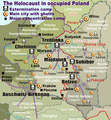
English: Map of the Holocaust in occupied Poland during World War II. The outline shows the borders of the Second Polish Republic at the time of the Nazi-German-and-Soviet invasion of Poland in 1939 with demarcation line between the two invading armies marked in red. Internal boundaries show the administrative divisions of occupied territories imposed by Nazi Germany when the Final Solution was set in motion during and after Operation Barbarossa of 1941.
This map shows all Nazi German extermination camps (or death camps), as well as prominent concentration, labour and prison camps, major pre-WW2 Polish cities with the new Jewish ghettos set up by Nazi Germany, major deportation routes, and major massacre sites.
Notes:
1. Extermination camps – marked with white skulls in black squares – are six dedicated facilities used for the mass gassings of prisoners, but all camps and ghettos took a toll of many, many lives.
2. Concentration camps – marked with black squares – feature only the most notorious forced-labor camps, prison camps & transit camps.
3. Sites of mass shootings into remote ravines – marked with white skulls – include Bronna Góra, Ponary and others. They were utilized during the 'Holocaust by bullets'.
4. Destruction ghettos – marked with Yellow stars in red circles – existed in most Polish cities. Only a selection is shown.
5. Major deportation routes travelled by the Holocaust trains are marked with RosyBrown arrows.
6. Most camps & ghettos which are not well known have been excluded for clarity.
7. District borders are at the height of Axis domination (1942).
8. Regions have German designations (e.g. "Ostland"), with the country name denoted in uppercase letters, e.g. LITHUANIA, CZECHOSLOVAKIA, or in parenthesis below the German occupational designation, e.g. (POLAND).

തീയതി
സ്രോതസ്സ്

സ്വന്തം സൃഷ്ടി. Composite map derived from a variety of readily available sources which may or may not include:

സ്രഷ്ടാവ്
അനുമതി
(ഈ പ്രമാണത്തിന്റെ പുനരുപയോഗം)
PD, see below. The map is completely unrestricted for any Wikipedia/Wikimedia project.
മറ്റു പതിപ്പുകൾ

[തിരുത്തുക]

യൂറോപ്പ് 1942
യൂറോപ്പ് 2007
പോളണ്ട്
ഉക്രൈൻ
Reichskommissariat Ostland
Northeast Europe
ഈ പ്രമാണത്തിൽ നിന്നും സൃഷ്ടിച്ചവ:  San Francisco - ASA Confernece 2009 - Wikipedia map used.JPG

അനുമതി

For all derivative works of maps uploaded earlier see below.

ഈ സൃഷ്ടിയുടെ പകർപ്പവകാശ ഉടമയായ Poeticbent (en), താഴെ പറയുന്ന അനുമതിയിൽ ഈ സൃഷ്ടി ഇതിനാൽ പ്രസിദ്ധീകരിച്ചിരിക്കുന്നു:
Public domain ഈ സൃഷ്ടിയുടെ പകർപ്പവകാശ ഉടമയായ ഞാൻ, ഈ സൃഷ്ടി പൊതുസഞ്ചയത്തിൽ പ്രസിദ്ധീകരിച്ചിരിക്കുന്നു. ഇത് ആഗോള തലത്തിൽ ബാധകമാണ്.
ചില രാജ്യങ്ങളിൽ ഇത് നിയമപ്രകാരം സാദ്ധ്യമല്ലെന്ന് വന്നേക്കാം; അങ്ങനെയെങ്കിൽ:
ഈ സൃഷ്ടി, നിയമപ്രകാരം നിബന്ധനകൾ ഉണ്ടെങ്കിൽ അവയൊഴിച്ച്, യാതൊരു നിബന്ധനകളും ഇല്ലാതെ ഏതൊരാൾക്കും ഏതൊരു ഉപയോഗത്തിനും, ഉപയോഗപ്പെടുത്തുവാൻ ഞാൻ അനുവദിച്ചിരിക്കുന്നു.
File uploaded previously
ഈ സൃഷ്ടിയുടെ പകർപ്പവകാശ ഉടമയായ Dennis Nilsson, താഴെ പറയുന്ന അനുമതിയിൽ ഈ സൃഷ്ടി ഇതിനാൽ പ്രസിദ്ധീകരിച്ചിരിക്കുന്നു:
w:ml:ക്രിയേറ്റീവ് കോമൺസ്
കടപ്പാട്
ഈ പ്രമാണത്തിന് അനുമതി നൽകപ്പെട്ടിരിക്കുന്നത് ക്രിയേറ്റീവ് കോമൺസ് ആട്രിബ്യൂഷൻ 3.0 അൺപോർട്ടഡ് അനുവാദപത്ര പ്രകാരമാണ്.
കടപ്പാട്: Dennis Nilsson
താങ്കൾക്കുള്ള സ്വാതന്ത്ര്യങ്ങൾ:
  • പങ്ക് വെയ്ക്കൽ – കൃതി പകർത്താനും, വിതരണം ചെയ്യാനും, പ്രസരിപ്പിക്കാനും
  • പുനഃമിശ്രണം ചെയ്യൽ – കൃതി അനുയുക്തമാക്കാൻ
താഴെ പറയുന്ന ഉപാധികൾ പാലിക്കുക:
  • കടപ്പാട് – രചയിതാവോ അനുമതിയുള്ളയാളോ വ്യക്തമാക്കിയിട്ടുള്ള വിധത്തിൽ കൃതിയ്ക്കുള്ള കടപ്പാട് താങ്കൾ നൽകിയിരിക്കണം. താങ്കൾക്കിത് ഏത് വിധത്തിൽ വേണമെങ്കിലും ചെയ്യാവുന്നതാണ്, പക്ഷേ അത് അവർ താങ്കളേയോ താങ്കളുടെ ഉപയോഗത്തേയോ അടിച്ചേൽപ്പിച്ചതു പോലെയാവരുത്.

Derivative work: Piotr Konieczny aka Prokonsul Piotrus Talk ഈ പ്രമാണത്തിൽ നിന്നും സൃഷ്ടിച്ചവ:

Derivative work: User:Poeticbent (Talk) ഈ പ്രമാണത്തിൽ നിന്നും സൃഷ്ടിച്ചവ:

Uploaded previously
ഇത് ഒരു മിനുക്കിയെടുത്ത ചിത്രമാണ്, യഥാർത്ഥ പതിപ്പിൽ നിന്ന് ഡിജിറ്റലായി മാറ്റങ്ങൾ വരുത്തിയിട്ടുണ്ടെന്നാണ് ഇതിനർത്ഥം. മാറ്റങ്ങൾ: Smaller version: occupied Poland only (pre-WWII borders). യഥാർത്ഥ പതിപ്പ് ഇവിടെ കാണാം: WW2-Holocaust-Europe.png.

ഈ സൃഷ്ടിയുടെ പകർപ്പവകാശ ഉടമയായ ഞാൻ, താഴെ പറയുന്ന അനുമതിയിൽ ഈ സൃഷ്ടി ഇതിനാൽ പ്രസിദ്ധീകരിക്കുന്നു:
w:ml:ക്രിയേറ്റീവ് കോമൺസ്
കടപ്പാട്
ഈ പ്രമാണത്തിന് അനുമതി നൽകപ്പെട്ടിരിക്കുന്നത് ക്രിയേറ്റീവ് കോമൺസ് ആട്രിബ്യൂഷൻ 3.0 അൺപോർട്ടഡ് അനുവാദപത്ര പ്രകാരമാണ്.
താങ്കൾക്കുള്ള സ്വാതന്ത്ര്യങ്ങൾ:
  • പങ്ക് വെയ്ക്കൽ – കൃതി പകർത്താനും, വിതരണം ചെയ്യാനും, പ്രസരിപ്പിക്കാനും
  • പുനഃമിശ്രണം ചെയ്യൽ – കൃതി അനുയുക്തമാക്കാൻ
താഴെ പറയുന്ന ഉപാധികൾ പാലിക്കുക:
  • കടപ്പാട് – രചയിതാവോ അനുമതിയുള്ളയാളോ വ്യക്തമാക്കിയിട്ടുള്ള വിധത്തിൽ കൃതിയ്ക്കുള്ള കടപ്പാട് താങ്കൾ നൽകിയിരിക്കണം. താങ്കൾക്കിത് ഏത് വിധത്തിൽ വേണമെങ്കിലും ചെയ്യാവുന്നതാണ്, പക്ഷേ അത് അവർ താങ്കളേയോ താങ്കളുടെ ഉപയോഗത്തേയോ അടിച്ചേൽപ്പിച്ചതു പോലെയാവരുത്.

യഥാർത്ഥ അപ്‌‌ലോഡ് രേഖ

For derivative works of the first uploaded file created by User:Dna-webmaster see the following:

ഡെറിവേറ്റീവ്എഫ്എക്സ് ഉപയോഗിച്ചാണ് അപ്‌ലോഡ് ചെയ്തത്

തലവാചകങ്ങൾ

ഈ പ്രമാണം എന്തിനെ പ്രതിനിധീകരിക്കുന്നുവെന്ന ഒറ്റവരി വിശദീകരണം ചേർക്കുക
Holocaust in occupied Poland

ഈ പ്രമാണത്തിൽ ചിത്രീകരിച്ചിരിക്കുന്ന ഇനങ്ങൾ

സൃഷ്ടിയിലുള്ളത്

27 ജൂൺ 2013

പ്രമാണ നാൾവഴി

ഏതെങ്കിലും തീയതി/സമയ കണ്ണിയിൽ ഞെക്കിയാൽ പ്രസ്തുതസമയത്ത് ഈ പ്രമാണം എങ്ങനെയായിരുന്നു എന്നു കാണാം.

(ഏറ്റവും പുതിയവ | ഏറ്റവും പഴയവ) പുതിയ 10 | എണ്ണം കാണുക (10 | 20 | 50 | 100 | 250 | 500)
തീയതി/സമയംലഘുചിത്രംഅളവുകൾഉപയോക്താവ്അഭിപ്രായം
നിലവിലുള്ളത്15:46, 10 മാർച്ച് 202015:46, 10 മാർച്ച് 2020-ലെ പതിപ്പിന്റെ ലഘുചിത്രം2,007 × 2,161 (1.34 എം.ബി.)Claude ZygielCosmetics
20:33, 28 മാർച്ച് 201820:33, 28 മാർച്ച് 2018-ലെ പതിപ്പിന്റെ ലഘുചിത്രം2,007 × 2,161 (1.48 എം.ബി.)Poeticbentnot an improvement: img looks muddy but I have original Photoshop layers, and can adjust them individually; comment on specifics in talk please
17:48, 27 മാർച്ച് 201817:48, 27 മാർച്ച് 2018-ലെ പതിപ്പിന്റെ ലഘുചിത്രം2,007 × 2,161 (1.49 എം.ബി.)HohumToo much information competing for attention in a very busy image. Toned down region name brightness, desaturated slightly.
05:38, 10 ജൂലൈ 201705:38, 10 ജൂലൈ 2017-ലെ പതിപ്പിന്റെ ലഘുചിത്രം2,007 × 2,161 (1.48 എം.ബി.)Poeticbentvital updates following a discussion → prominent ghettos, legend
19:43, 25 ജൂലൈ 201519:43, 25 ജൂലൈ 2015-ലെ പതിപ്പിന്റെ ലഘുചിത്രം2,007 × 2,161 (1.46 എം.ബി.)Poeticbentname of settlement: Górka Połonka, source Wolyn.ovh.org
18:27, 2 ഡിസംബർ 201418:27, 2 ഡിസംബർ 2014-ലെ പതിപ്പിന്റെ ലഘുചിത്രം2,007 × 2,161 (1.46 എം.ബി.)Poeticbentadded one missing marker
19:17, 7 മേയ് 201419:17, 7 മേയ് 2014-ലെ പതിപ്പിന്റെ ലഘുചിത്രം2,007 × 2,161 (1.45 എം.ബി.)Poeticbentlocation of Bronna Góra
17:34, 4 ഏപ്രിൽ 201417:34, 4 ഏപ്രിൽ 2014-ലെ പതിപ്പിന്റെ ലഘുചിത്രം2,007 × 2,161 (1.44 എം.ബി.)PoeticbentLachwa Ghetto location
21:31, 27 ജൂൺ 201321:31, 27 ജൂൺ 2013-ലെ പതിപ്പിന്റെ ലഘുചിത്രം2,007 × 2,161 (1.42 എം.ബി.)Poeticbentmajor expansion with similar color-scheme
03:09, 28 ജൂൺ 201103:09, 28 ജൂൺ 2011-ലെ പതിപ്പിന്റെ ലഘുചിത്രം364 × 339 (123 കെ.ബി.)LMK3changed the color of the Soviet Curzon line to indicate the two different occupation zones before Operation Barbarossa, refined the location of Warsaw
(ഏറ്റവും പുതിയവ | ഏറ്റവും പഴയവ) പുതിയ 10 | എണ്ണം കാണുക (10 | 20 | 50 | 100 | 250 | 500)

പ്രമാണത്തിന്റെ ആഗോള ഉപയോഗം

താഴെ കൊടുത്തിരിക്കുന്ന മറ്റ് വിക്കികൾ ഈ പ്രമാണം ഉപയോഗിക്കുന്നു:

ഈ പ്രമാണത്തിന്റെ കൂടുതൽ ആഗോള ഉപയോഗം കാണുക.

മെറ്റാഡാറ്റ

"https://ml.wikipedia.org/wiki/പ്രമാണം:WW2-Holocaust-Poland.PNG" എന്ന താളിൽനിന്ന് ശേഖരിച്ചത്