പ്രമാണം:Tarrant County Texas Incorporated Areas Arlington highlighted.svg

ഈ SVG പ്രമാണത്തിന്റെ PNG പ്രിവ്യൂവിന്റെ വലിപ്പം: 800 × 436 പിക്സലുകൾ. മറ്റ് റെസലൂഷനുകൾ: 320 × 175 പിക്സലുകൾ | 640 × 349 പിക്സലുകൾ | 1,024 × 559 പിക്സലുകൾ | 1,280 × 698 പിക്സലുകൾ | 2,560 × 1,396 പിക്സലുകൾ.
പൂർണ്ണ വലിപ്പം (എസ്.വി.ജി. പ്രമാണം, നാമമാത്രമായ 1,100 × 600 പിക്സലുകൾ, പ്രമാണത്തിന്റെ വലിപ്പം: 235 കെ.ബി.)
| ഈ പ്രമാണം വിക്കിമീഡിയ കോമൺസിൽ നിന്നുള്ളതാണ്. പ്രമാണത്തെക്കുറിച്ചുള്ള വിവരണം താഴെ കൊടുത്തിരിക്കുന്നു.
|
ചുരുക്കം
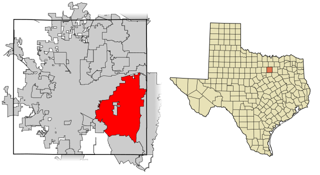
| വിവരണം | This map shows the incorporated areas in Tarrant County, Texas. Arlington is highlighted in red. I created it in Inkscape using data from the following links: North Central Texas Council of Governments Maps Website, City of Fort Worth Interactive Zoning Map |
| തീയതി | |
| സ്രോതസ്സ് | My own work, based on government information. Though I strove to be as accurate in the detail as possible, the information shown is not guaranteed to be completely accurate. |
| സ്രഷ്ടാവ് | Ixnayonthetimmay |
| അനുമതി (ഈ പ്രമാണത്തിന്റെ പുനരുപയോഗം) |
Public Domain |
| മറ്റു പതിപ്പുകൾ | See Category:Maps of Tarrant County, Texas for other versions of this image. |
അനുമതി
| ഈ സൃഷ്ടിയുടെ പകർപ്പവകാശ ഉടമയായ ഞാൻ, ഈ സൃഷ്ടി പൊതുസഞ്ചയത്തിൽ പ്രസിദ്ധീകരിച്ചിരിക്കുന്നു. ഇത് ആഗോള തലത്തിൽ ബാധകമാണ്. ചില രാജ്യങ്ങളിൽ ഇത് നിയമപ്രകാരം സാദ്ധ്യമല്ലെന്ന് വന്നേക്കാം; അങ്ങനെയെങ്കിൽ: ഈ സൃഷ്ടി, നിയമപ്രകാരം നിബന്ധനകൾ ഉണ്ടെങ്കിൽ അവയൊഴിച്ച്, യാതൊരു നിബന്ധനകളും ഇല്ലാതെ ഏതൊരാൾക്കും ഏതൊരു ഉപയോഗത്തിനും, ഉപയോഗപ്പെടുത്തുവാൻ ഞാൻ അനുവദിച്ചിരിക്കുന്നു. |
പ്രമാണ നാൾവഴി
ഏതെങ്കിലും തീയതി/സമയ കണ്ണിയിൽ ഞെക്കിയാൽ പ്രസ്തുതസമയത്ത് ഈ പ്രമാണം എങ്ങനെയായിരുന്നു എന്നു കാണാം.
| തീയതി/സമയം | ലഘുചിത്രം | അളവുകൾ | ഉപയോക്താവ് | അഭിപ്രായം | |
|---|---|---|---|---|---|
| നിലവിലുള്ളത് | 10:37, 4 സെപ്റ്റംബർ 2007 | | 1,100 × 600 (235 കെ.ബി.) | Ixnayonthetimmay | == Summary == {{Information |Description=This map shows the incorporated areas in Tarrant County, Texas. Arlington is highlighted in red. I created it in [[en:Inksca |
പ്രമാണത്തിന്റെ ഉപയോഗം
താഴെ കാണുന്ന താളിൽ ഈ ചിത്രം ഉപയോഗിക്കുന്നു:
പ്രമാണത്തിന്റെ ആഗോള ഉപയോഗം
താഴെ കൊടുത്തിരിക്കുന്ന മറ്റ് വിക്കികൾ ഈ പ്രമാണം ഉപയോഗിക്കുന്നു:
- af.wikipedia.org സംരംഭത്തിലെ ഉപയോഗം
- ang.wikipedia.org സംരംഭത്തിലെ ഉപയോഗം
- ar.wikipedia.org സംരംഭത്തിലെ ഉപയോഗം
- arz.wikipedia.org സംരംഭത്തിലെ ഉപയോഗം
- bn.wikipedia.org സംരംഭത്തിലെ ഉപയോഗം
- br.wikipedia.org സംരംഭത്തിലെ ഉപയോഗം
- ca.wikipedia.org സംരംഭത്തിലെ ഉപയോഗം
- ceb.wikipedia.org സംരംഭത്തിലെ ഉപയോഗം
- cs.wikipedia.org സംരംഭത്തിലെ ഉപയോഗം
- de.wikipedia.org സംരംഭത്തിലെ ഉപയോഗം
- el.wikipedia.org സംരംഭത്തിലെ ഉപയോഗം
- en.wikipedia.org സംരംഭത്തിലെ ഉപയോഗം
- eo.wikipedia.org സംരംഭത്തിലെ ഉപയോഗം
- es.wikipedia.org സംരംഭത്തിലെ ഉപയോഗം
- et.wikipedia.org സംരംഭത്തിലെ ഉപയോഗം
- eu.wikipedia.org സംരംഭത്തിലെ ഉപയോഗം
- fa.wikipedia.org സംരംഭത്തിലെ ഉപയോഗം
- fi.wikipedia.org സംരംഭത്തിലെ ഉപയോഗം
- ga.wikipedia.org സംരംഭത്തിലെ ഉപയോഗം
- gl.wikipedia.org സംരംഭത്തിലെ ഉപയോഗം
- hi.wikipedia.org സംരംഭത്തിലെ ഉപയോഗം
- hr.wikipedia.org സംരംഭത്തിലെ ഉപയോഗം
- ht.wikipedia.org സംരംഭത്തിലെ ഉപയോഗം
- hu.wikipedia.org സംരംഭത്തിലെ ഉപയോഗം
- ia.wikipedia.org സംരംഭത്തിലെ ഉപയോഗം
- incubator.wikimedia.org സംരംഭത്തിലെ ഉപയോഗം
- io.wikipedia.org സംരംഭത്തിലെ ഉപയോഗം
- it.wikipedia.org സംരംഭത്തിലെ ഉപയോഗം
- ja.wikipedia.org സംരംഭത്തിലെ ഉപയോഗം
- kw.wikipedia.org സംരംഭത്തിലെ ഉപയോഗം
- ms.wikipedia.org സംരംഭത്തിലെ ഉപയോഗം
- nl.wikipedia.org സംരംഭത്തിലെ ഉപയോഗം
- pnb.wikipedia.org സംരംഭത്തിലെ ഉപയോഗം
- pt.wikipedia.org സംരംഭത്തിലെ ഉപയോഗം
- ro.wikipedia.org സംരംഭത്തിലെ ഉപയോഗം
- sc.wikipedia.org സംരംഭത്തിലെ ഉപയോഗം
- simple.wikipedia.org സംരംഭത്തിലെ ഉപയോഗം
- sk.wikipedia.org സംരംഭത്തിലെ ഉപയോഗം
- sl.wikipedia.org സംരംഭത്തിലെ ഉപയോഗം
- sr.wikipedia.org സംരംഭത്തിലെ ഉപയോഗം
- sv.wikipedia.org സംരംഭത്തിലെ ഉപയോഗം
- sw.wikipedia.org സംരംഭത്തിലെ ഉപയോഗം
- th.wikipedia.org സംരംഭത്തിലെ ഉപയോഗം
- tr.wikipedia.org സംരംഭത്തിലെ ഉപയോഗം
- tt.wikipedia.org സംരംഭത്തിലെ ഉപയോഗം
- ur.wikipedia.org സംരംഭത്തിലെ ഉപയോഗം
- vo.wikipedia.org സംരംഭത്തിലെ ഉപയോഗം
- www.wikidata.org സംരംഭത്തിലെ ഉപയോഗം
- yo.wikipedia.org സംരംഭത്തിലെ ഉപയോഗം
- zh.wikipedia.org സംരംഭത്തിലെ ഉപയോഗം