പ്രമാണം:Qing China 1820.png
ഈ പ്രിവ്യൂവിന്റെ വലിപ്പം: 800 × 593 പിക്സലുകൾ. മറ്റ് റെസലൂഷനുകൾ: 320 × 237 പിക്സലുകൾ | 640 × 475 പിക്സലുകൾ | 910 × 675 പിക്സലുകൾ.
പൂർണ്ണ വലിപ്പം (910 × 675 പിക്സൽ, പ്രമാണത്തിന്റെ വലിപ്പം: 327 കെ.ബി., മൈം തരം: image/png)
| ഈ പ്രമാണം വിക്കിമീഡിയ കോമൺസിൽ നിന്നുള്ളതാണ്. പ്രമാണത്തെക്കുറിച്ചുള്ള വിവരണം താഴെ കൊടുത്തിരിക്കുന്നു.
|
| വിവരണം |
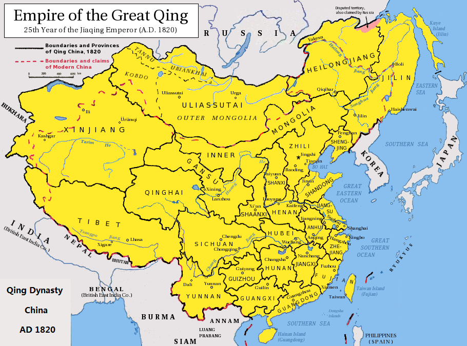
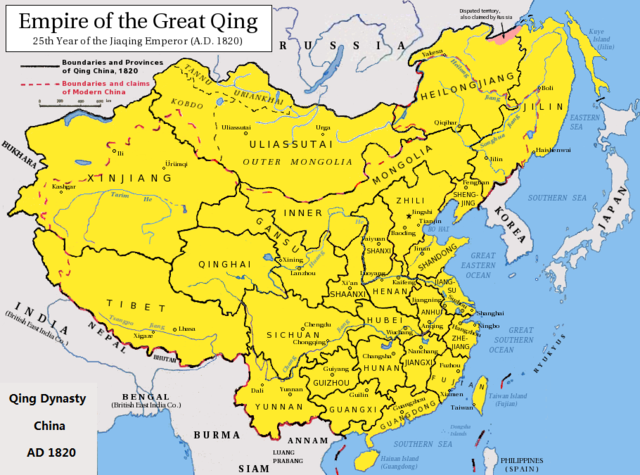
English: Map of the Qing Dynasty China in 1820. (Includes provincial boundaries and the boundaries of modern China for reference.) Adapted from http://en.wikipedia.org/wiki/Image:ROC_PRC_comparison_eng.jpg and information complied from other sources such as http://baike.baidu.com/view/5405.htm , http://map.huhai.net/58-59.jpg and http://www.sina7.com/jdwh/UploadFiles_6109/200709/20070918093610860.jpg 中文(简体):大清嘉庆二十五年疆域图。 中文(繁體):大清嘉慶廿五年疆域圖。 日本語: 大清の嘉慶25年の疆域の図。 Tiếng Việt: Đại Thanh bản đồ (1820). |
| തീയതി | (UTC) |
| സ്രോതസ്സ് |
|
| സ്രഷ്ടാവ് |
|
| ഇത് ഒരു മിനുക്കിയെടുത്ത ചിത്രമാണ്, യഥാർത്ഥ പതിപ്പിൽ നിന്ന് ഡിജിറ്റലായി മാറ്റങ്ങൾ വരുത്തിയിട്ടുണ്ടെന്നാണ് ഇതിനർത്ഥം. മാറ്റങ്ങൾ: border islands. യഥാർത്ഥ പതിപ്പ് ഇവിടെ കാണാം: Qing Dynasty 1820.png.
|
ഈ സൃഷ്ടിയുടെ പകർപ്പവകാശ ഉടമയായ ഞാൻ, താഴെ പറയുന്ന അനുമതികളിൽ ഈ സൃഷ്ടി ഇതിനാൽ പ്രസിദ്ധീകരിക്കുന്നു:
ഈ പ്രമാണത്തിന് അനുമതി നൽകപ്പെട്ടിരിക്കുന്നത് ക്രിയേറ്റീവ് കോമൺസ് ആട്രിബ്യൂഷൻ-ഷെയർ എലൈക് 3.0 അൺപോർട്ടഡ് അനുവാദപത്ര പ്രകാരമാണ്.
- താങ്കൾക്കുള്ള സ്വാതന്ത്ര്യങ്ങൾ:
- പങ്ക് വെയ്ക്കൽ – കൃതി പകർത്താനും, വിതരണം ചെയ്യാനും, പ്രസരിപ്പിക്കാനും
- പുനഃമിശ്രണം ചെയ്യൽ – കൃതി അനുയുക്തമാക്കാൻ
- താഴെ പറയുന്ന ഉപാധികൾ പാലിക്കുക:
- കടപ്പാട് – രചയിതാവോ അനുമതിയുള്ളയാളോ വ്യക്തമാക്കിയിട്ടുള്ള വിധത്തിൽ കൃതിയ്ക്കുള്ള കടപ്പാട് താങ്കൾ നൽകിയിരിക്കണം. താങ്കൾക്കിത് ഏത് വിധത്തിൽ വേണമെങ്കിലും ചെയ്യാവുന്നതാണ്, പക്ഷേ അത് അവർ താങ്കളേയോ താങ്കളുടെ ഉപയോഗത്തേയോ അടിച്ചേൽപ്പിച്ചതു പോലെയാവരുത്.
- ഇതു പോലെ പങ്ക് വെയ്ക്കുക – ഈ സൃഷ്ടിയെ പുനഃമിശ്രണം ചെയ്തോ രൂപാന്തരപ്പെടുത്തിയോ അടിസ്ഥാനപ്പെടുത്തിയോ ഉണ്ടാക്കുന്നവ; താങ്കളുടെ സംഭാവനയടക്കമുള്ള സൃഷ്ടി യഥാർത്ഥ സൃഷ്ടിയുടെ അതേ അല്ലെങ്കിൽ അനുരൂപമായ ഉപയോഗാനുമതിയിൽ മാത്രമേ താങ്കൾ വിതരണം ചെയ്യാവൂ.

|
സ്വതന്ത്ര സോഫ്റ്റ്വേർ സമിതി പ്രസിദ്ധീകരിച്ചിട്ടുള്ള ഗ്നു സ്വതന്ത്ര പ്രമാണ അനുവാദപത്രം പതിപ്പ് 1.2 അല്ലെങ്കിൽ പുതിയ പതിപ്പുകൾ പ്രകാരം; മാറ്റമില്ലാത്ത ഭാഗങ്ങളില്ലാതെ, മുൻചട്ടയിലെ എഴുത്തുകൾ ഇല്ലാതെ, പിൻചട്ടയിലെ എഴുത്തുകൾ ഇല്ലാതെ പകർത്താനും, വിതരണം ചെയ്യാനും ഒപ്പം/അല്ലെങ്കിൽ ഈ പ്രമാണത്തിൽ മാറ്റം വരുത്തുവാനും ഉള്ള അവകാശങ്ങൾ നൽകുന്നു. ഗ്നു സ്വതന്ത്ര പ്രമാണ അനുവാദപത്രം എന്ന തലക്കെട്ടിൽ അനുവാദപത്രത്തിന്റെ ഒരു പകർപ്പ് ഉൾപ്പെടുത്തിയിട്ടുണ്ട്. |
താങ്കൾക്ക് താങ്കളുടെ ഇച്ഛാനുസരണം അനുമതി തിരഞ്ഞെടുക്കാം.
യഥാർത്ഥ അപ്ലോഡ് രേഖ
This image is a derivative work of the following images:
- File:Qing_Dynasty_1820.png licensed with Cc-by-sa-3.0, GFDL
- 2010-06-22T03:48:22Z Benlisquare 910x675 (363965 Bytes) Revert - redraw the map yourself. MS Paint overlaying of a corner is an eyesore. Illogical to have the title repeated twice.
- 2010-06-21T21:46:33Z Hisacw 910x675 (395648 Bytes) rv to NPOVify: the status on certain outlier islands (e.g. Sakhalin) is not explicitly defined, c.f. the map [http://go-passport.grolier.com/map?id=mh00032&pid=go]
- 2010-06-20T05:59:11Z Benlisquare 910x675 (363965 Bytes) Reverted to version as of 19:58, 27 September 2008
- 2010-06-20T05:58:44Z Benlisquare 910x675 (363965 Bytes) possible POV vandal
- 2010-06-19T05:34:53Z Hisacw 910x675 (395648 Bytes) small adj from original
- 2008-10-15T02:32:20Z Pryaltonian 910x675 (363965 Bytes) Reverted to version as of 19:58, 27 September 2008
- 2008-10-15T02:29:27Z Pryaltonian 910x675 (400039 Bytes) [[Category:China]] [[Category:Taiwan]] [[Category:Tibet]] [[Category:Mongolia]]
- 2008-09-27T19:58:02Z Pryaltonian 910x675 (363965 Bytes) {{Information |Description={{en|1=Map of the Qing Dynasty at its greatest extent. Includes provincial boundaries and the boundaries of modern China for reference.}} |Source=Own work by uploader |Author=[[User:Pryaltonian|Pry
ഡെറിവേറ്റീവ്എഫ്എക്സ് ഉപയോഗിച്ചാണ് അപ്ലോഡ് ചെയ്തത്
പ്രമാണ നാൾവഴി
ഏതെങ്കിലും തീയതി/സമയ കണ്ണിയിൽ ഞെക്കിയാൽ പ്രസ്തുതസമയത്ത് ഈ പ്രമാണം എങ്ങനെയായിരുന്നു എന്നു കാണാം.
| തീയതി/സമയം | ലഘുചിത്രം | അളവുകൾ | ഉപയോക്താവ് | അഭിപ്രായം | |
|---|---|---|---|---|---|
| നിലവിലുള്ളത് | 06:02, 23 ഫെബ്രുവരി 2020 | | 910 × 675 (327 കെ.ബി.) | Morrisonjohn022 | Reverted to version as of 17:00, 23 July 2011 (UTC) While the indigenous peoples of Sakhalin was not Han Chinese, Sakhalin was claimed by the Qing Empire and it was recognized as such by other countries (until the 1858 Treaty of Aigun and 1860 Treaty of Peking gave the island to Russia). See p. 11 of "Restless Empire: China and the World Since 1750" by Odd Arne Westad, p. 200 of "Ethnic Groups of North, East, and Central Asia: An Encyclopedia" by James B. Minahan, and p. 2 of "Across Forest,... |
| 12:35, 26 ഒക്ടോബർ 2019 |  | 910 × 675 (386 കെ.ബി.) | Artanisen | Reverted to version as of 22:40, 24 October 2010 (UTC) Sakhalin was not Chinese. It was first occupied by the indigenous Ainu people and later it became half Japanese (Karafuto) and Russian (Sakhalin) then it became wholly part of the Russian Federation after WW2 | |
| 17:00, 23 ജൂലൈ 2011 |  | 910 × 675 (327 കെ.ബി.) | Shibo77 | .. | |
| 22:40, 24 ഒക്ടോബർ 2010 |  | 910 × 675 (386 കെ.ബി.) | Wengier | minor | |
| 22:35, 24 ഒക്ടോബർ 2010 |  | 910 × 675 (386 കെ.ബി.) | Wengier | {{Information |Description={{en|1=Map of the Qing Dynasty China in 1820. (Includes provincial boundaries and the boundaries of modern China for reference.)<br/>Adapted from http://en.wikipedia.org/wiki/Image:ROC_PRC_comparison_eng.jpg and information comp |
പ്രമാണത്തിന്റെ ഉപയോഗം
താഴെ കാണുന്ന താളിൽ ഈ ചിത്രം ഉപയോഗിക്കുന്നു:
പ്രമാണത്തിന്റെ ആഗോള ഉപയോഗം
താഴെ കൊടുത്തിരിക്കുന്ന മറ്റ് വിക്കികൾ ഈ പ്രമാണം ഉപയോഗിക്കുന്നു:
- bcl.wikipedia.org സംരംഭത്തിലെ ഉപയോഗം
- be.wikipedia.org സംരംഭത്തിലെ ഉപയോഗം
- bn.wikipedia.org സംരംഭത്തിലെ ഉപയോഗം
- en.wikipedia.org സംരംഭത്തിലെ ഉപയോഗം
- hi.wikipedia.org സംരംഭത്തിലെ ഉപയോഗം
- pl.wikipedia.org സംരംഭത്തിലെ ഉപയോഗം
- pnb.wikipedia.org സംരംഭത്തിലെ ഉപയോഗം
- ru.wikipedia.org സംരംഭത്തിലെ ഉപയോഗം
- tl.wikipedia.org സംരംഭത്തിലെ ഉപയോഗം
- ur.wikipedia.org സംരംഭത്തിലെ ഉപയോഗം
- zh.wikipedia.org സംരംഭത്തിലെ ഉപയോഗം