പ്രമാണം:Paraná River Floodplain, Northern Argentina.jpg

പൂർണ്ണ വലിപ്പം (4,288 × 2,850 പിക്സൽ, പ്രമാണത്തിന്റെ വലിപ്പം: 3.8 എം.ബി., മൈം തരം: image/jpeg)
| ഈ പ്രമാണം വിക്കിമീഡിയ കോമൺസിൽ നിന്നുള്ളതാണ്. പ്രമാണത്തെക്കുറിച്ചുള്ള വിവരണം താഴെ കൊടുത്തിരിക്കുന്നു.
|
ചുരുക്കം
| വിവരണം |
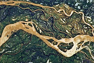
English: This astronaut photograph shows a 29-kilometre stretch of the Paraná, downstream of the small city of Goya, Argentina (just off the top left of the image).
The Paraná River ranges up to 3 kilometres wide along the reach illustrated in this image. The main channel is deep enough to allow smaller ocean-going ships to pass north to the capital city of Asunción, Paraguay, fully 1,200 kilometres inland and well out of the image. The river’s dark brown shading indicates a heavy load of muddy sediment; smaller side channels also carry this mud. Numerous lakes are typical on active floodplains, and appear here as irregular bodies of water. Some appear brown, indicating that they probably have been refilled during recent rises and floods of the active channels. The Paraná floodplain occupies the entire image; it is so wide—18 kilometres in this view—that its banks are not visible. Numerous curved, meandering channels are the most prominent characteristic of the floodplain, indicating prior positions of the river and its channels. As riverbeds move laterally by natural processes, they leave remnants of their channels, which appear as lakes and finally fill with mud. This is an excellent image for illustrating these meander forms. From a geological standpoint, it is interesting that almost all of the old channels are similar in curvature to today’s side channels. However, almost none of them seem to show prior positions of the main, wide Paraná channel. |
| തീയതി | |
| സ്രോതസ്സ് | NASA Earth Observatory |
| സ്രഷ്ടാവ് | ISS Expedition 27 crew |
| ഛായാഗ്രാഹിയുടെ സ്ഥാനം | | സ്ഥാനമനുസരിച്ച് ഇതും മറ്റു ചിത്രങ്ങളും: ഓപ്പൺസ്ട്രീറ്റ്മാപ്പ് |
|---|
ഈ ചിത്രം അല്ലെങ്കിൽ ചലച്ചിത്രം അമേരിക്കൻ ഐക്യനാടുകളിലെ നാസയുടെ (NASA) ജോൺസൺ ബഹിരാകാശ കേന്ദ്രത്തിൽ നിന്ന് പ്രസിദ്ധീകരിച്ചതാണ്, ഫോട്ടോ ഐ.ഡി.: ISS027-E-11058. ഈ റ്റാഗ് ഇത് ഉൾപ്പെടുത്തിയിരിക്കുന്ന സൃഷ്ടിയുടെ പകർപ്പവകാശസ്ഥിതിയെ സൂചിപ്പിക്കുന്നില്ല. ഒരു സാധാരണ പകർപ്പവകാശ റ്റാഗ് ആവശ്യമാണ്. കോമൺസ്:അനുമതി നൽകൽ കാണുക. മറ്റു ഭാഷകൾ:
|
Image acquired with a Nikon D2Xs digital camera using a 400 mm lens, and is provided by the ISS Crew Earth Observations experiment and Image Science & Analysis Laboratory, Johnson Space Center.
അനുമതി
| ഈ പ്രമാണം നാസ സൃഷ്ടിച്ചതായതിനാൽ പൊതുസഞ്ചയത്തിൽ വരുന്നു. "നാസ നൽകുന്ന വിവരങ്ങൾ മറ്റുവിധത്തിൽ കുറിച്ചിട്ടില്ലെങ്കിൽ പൊതുസഞ്ചയത്തിൽ വരുന്നു എന്നാണ് നാസയുടെ പകർപ്പവകാശ നയം വ്യക്തമാക്കുന്നത്". (Template:PD-USGov, നാസ പകർപ്പവകാശ നയം താൾ ഒപ്പം JPL ചിത്ര ഉപയോഗ നയം എന്നിവ കാണുക.) | ||
 |
മുന്നറിയിപ്പുകൾ:
|
| Annotations | This image is annotated: View the annotations at Commons |
പ്രമാണ നാൾവഴി
ഏതെങ്കിലും തീയതി/സമയ കണ്ണിയിൽ ഞെക്കിയാൽ പ്രസ്തുതസമയത്ത് ഈ പ്രമാണം എങ്ങനെയായിരുന്നു എന്നു കാണാം.
| തീയതി/സമയം | ലഘുചിത്രം | അളവുകൾ | ഉപയോക്താവ് | അഭിപ്രായം | |
|---|---|---|---|---|---|
| നിലവിലുള്ളത് | 11:54, 2 മേയ് 2011 | | 4,288 × 2,850 (3.8 എം.ബി.) | Originalwana |
പ്രമാണത്തിന്റെ ഉപയോഗം
താഴെ കാണുന്ന താളിൽ ഈ ചിത്രം ഉപയോഗിക്കുന്നു:
പ്രമാണത്തിന്റെ ആഗോള ഉപയോഗം
താഴെ കൊടുത്തിരിക്കുന്ന മറ്റ് വിക്കികൾ ഈ പ്രമാണം ഉപയോഗിക്കുന്നു:
- ar.wikipedia.org സംരംഭത്തിലെ ഉപയോഗം
- de.wikipedia.org സംരംഭത്തിലെ ഉപയോഗം
- en.wikipedia.org സംരംഭത്തിലെ ഉപയോഗം
- eo.wikipedia.org സംരംഭത്തിലെ ഉപയോഗം
- fa.wikipedia.org സംരംഭത്തിലെ ഉപയോഗം
- he.wikipedia.org സംരംഭത്തിലെ ഉപയോഗം
- ko.wikipedia.org സംരംഭത്തിലെ ഉപയോഗം
- mk.wikipedia.org സംരംഭത്തിലെ ഉപയോഗം
- sr.wikipedia.org സംരംഭത്തിലെ ഉപയോഗം
- uk.wikipedia.org സംരംഭത്തിലെ ഉപയോഗം
- ur.wikipedia.org സംരംഭത്തിലെ ഉപയോഗം