പ്രമാണം:Merseyside UK location map.svg

ഈ SVG പ്രമാണത്തിന്റെ PNG പ്രിവ്യൂവിന്റെ വലിപ്പം: 565 × 599 പിക്സലുകൾ. മറ്റ് റെസലൂഷനുകൾ: 226 × 240 പിക്സലുകൾ | 453 × 480 പിക്സലുകൾ | 724 × 768 പിക്സലുകൾ | 966 × 1,024 പിക്സലുകൾ | 1,932 × 2,048 പിക്സലുകൾ | 1,231 × 1,305 പിക്സലുകൾ.
പൂർണ്ണ വലിപ്പം (എസ്.വി.ജി. പ്രമാണം, നാമമാത്രമായ 1,231 × 1,305 പിക്സലുകൾ, പ്രമാണത്തിന്റെ വലിപ്പം: 1.3 എം.ബി.)
| ഈ പ്രമാണം വിക്കിമീഡിയ കോമൺസിൽ നിന്നുള്ളതാണ്. പ്രമാണത്തെക്കുറിച്ചുള്ള വിവരണം താഴെ കൊടുത്തിരിക്കുന്നു.
|
| വിവരണം |
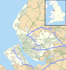
Map of Merseyside, UK with the following information shown:
Equirectangular map projection on WGS 84 datum, with N/S stretched 165% Geographic limits:
|
| തീയതി | |
| സ്രോതസ്സ് |
|
| സ്രഷ്ടാവ് | Nilfanion, created using Ordnance Survey data |
| അനുമതി (ഈ പ്രമാണത്തിന്റെ പുനരുപയോഗം) |
ഈ പ്രമാണത്തിന് അനുമതി നൽകപ്പെട്ടിരിക്കുന്നത് ക്രിയേറ്റീവ് കോമൺസ് ആട്രിബ്യൂഷൻ-ഷെയർ എലൈക് 3.0 അൺപോർട്ടഡ് അനുവാദപത്ര പ്രകാരമാണ്. കടപ്പാട്: Contains Ordnance Survey data © Crown copyright and database right
|
| മറ്റു പതിപ്പുകൾ | File:Bedfordshire UK district map (blank).svg - Blank map |
.svg)
പ്രമാണ നാൾവഴി
ഏതെങ്കിലും തീയതി/സമയ കണ്ണിയിൽ ഞെക്കിയാൽ പ്രസ്തുതസമയത്ത് ഈ പ്രമാണം എങ്ങനെയായിരുന്നു എന്നു കാണാം.
| തീയതി/സമയം | ലഘുചിത്രം | അളവുകൾ | ഉപയോക്താവ് | അഭിപ്രായം | |
|---|---|---|---|---|---|
| നിലവിലുള്ളത് | 19:01, 26 സെപ്റ്റംബർ 2010 | | 1,231 × 1,305 (1.3 എം.ബി.) | Nilfanion | {{Information |Description=Map of Merseyside, UK with the following information shown: *Administrative borders *Coastline, lakes and rivers *Roads and railways *Urban areas Equirectangular map projection on WGS 84 datum, with N/S stretche |
പ്രമാണത്തിന്റെ ഉപയോഗം
താഴെ കാണുന്ന 3 താളുകളിൽ ഈ ചിത്രം ഉപയോഗിക്കുന്നു:
പ്രമാണത്തിന്റെ ആഗോള ഉപയോഗം
താഴെ കൊടുത്തിരിക്കുന്ന മറ്റ് വിക്കികൾ ഈ പ്രമാണം ഉപയോഗിക്കുന്നു:
- ar.wikipedia.org സംരംഭത്തിലെ ഉപയോഗം
- ast.wikipedia.org സംരംഭത്തിലെ ഉപയോഗം
- bg.wikipedia.org സംരംഭത്തിലെ ഉപയോഗം
- br.wikipedia.org സംരംഭത്തിലെ ഉപയോഗം
- ceb.wikipedia.org സംരംഭത്തിലെ ഉപയോഗം
- en.wikipedia.org സംരംഭത്തിലെ ഉപയോഗം
- Liverpool John Lennon Airport
- Leasowe
- Birkenhead
- Prescot
- Kirkby
- Halewood
- Huyton
- Southport
- Rainhill
- Earlestown
- Bootle
- Great Crosby
- Newton-le-Willows
- Edge Hill, Liverpool
- Litherland
- Formby
- Maghull
- Aigburth
- Allerton, Liverpool
- St Michael's Hamlet
- Crosby, Merseyside
- Little Crosby
- Waterloo, Merseyside
- RAF Woodvale
- Liverpool Castle
- Bebington
- Toxteth
- Birkdale
- Hoylake
- West Derby
- Norris Green
- Everton, Liverpool
- Croxteth
- Anfield (suburb)
- Aintree
- Port Sunlight
- Dingle, Liverpool
- Lydiate
- Switch Island
- Melling, Merseyside
- Sefton, Merseyside
- Rainford
- Speke
- Childwall
ഈ പ്രമാണത്തിന്റെ കൂടുതൽ ആഗോള ഉപയോഗം കാണുക.